Property Record
0 Summit Valley Rd, Hesperia, CA 92345

Property Detail
0 Summit Valley Rd
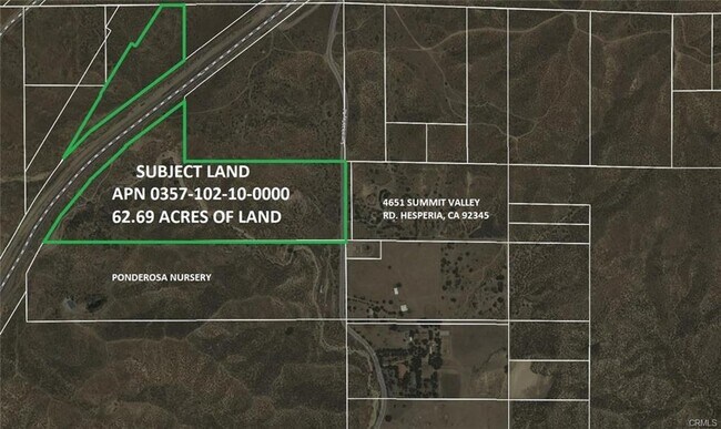
0357-102-10
N 1/2 S 1/2 NE 1/4 AND S 1/2 NW 1/4 NE 1/4 AND NE 1/4 NW 1/4 NE 1/4 SEC 21 TP 3N R 5W EX RR R/W AND EX S P CO R/W 62.69 AC
Vacantlandnec
SAN BERNARDINO
RS1
California
D Areas with possible but undetermined flood hazards.
62.69 AC
2025
Mojave River Valley
2025
Inland Empire (California)
010019
Riverside-San Bernardino-Ontario, CA
NEARBY LISTINGS FOR SALE OR LEASE
DEMOGRAPHICS near 0 Summit Valley Rd
1 mile
3 mile
5 mile
2025 Total Population
106
2,160
10,063
2030 Population
110
2,217
10,273
Pop Growth 2025-2030
+ 3.77%
+ 2.64%
+ 2.09%
Average Age
42
41
39
2025 Total Households
35
678
2,967
HH Growth 2025-2030
+ 2.86%
+ 2.51%
+ 2.02%
Median Household Inc
$91,666
$129,234
$92,425
Avg Household Size
3.10
3.10
3.30
2025 Avg HH Vehicles
3.00
3.00
3.00
Median Home Value
$602,941
$719,126
$564,030
Median Year Built
2002
2004
2001
Nearby Places
Map Layers
Map Styles
 Street
 Aerial
Layers
 Traffic
 Biking
Places
Listings with unknown addresses are not visible on the map
- Restaurants
- Banks
- Shops
- Fitness
- Groceries
PUBLIC TRANSPORTATION
AIRPORT
Ontario International
Drive
Walk
Distance
Ontario International
40 min
31.7 mi
Freight Ports
Port of Long Beach
Drive
Walk
Distance
Port of Long Beach
102 min
83.8 mi
SALE & LEASE HISTORY
LISTING DATE
SALE/LEASE

Nov 24, 2020
For Sale
Nearby Properties
Address
Land Use
TOTAL SIZE
Lot Size
Zoning
Address
Land Use
TOTAL SIZE
Lot Size
Zoning
123.35 AC
OHCG
Address
Land Use
TOTAL SIZE
Lot Size
Zoning
3,307 SF
0.88 AC
Address
Land Use
TOTAL SIZE
Lot Size
Zoning
7,224 SF
0.50 AC
OHCG
Address
Land Use
TOTAL SIZE
Lot Size
Zoning
3,056 SF
5.78 AC
OHCG
Address
Land Use
TOTAL SIZE
Lot Size
Zoning
11,000 SF
7.54 AC
OHCG
Address
Land Use
TOTAL SIZE
Lot Size
Zoning
31 SF
4.79 AC
OHFW
Address
Land Use
TOTAL SIZE
Lot Size
Zoning
1.36 AC
Address
Land Use
TOTAL SIZE
Lot Size
Zoning
1,596 SF
0.73 AC
Address
Land Use
TOTAL SIZE
Lot Size
Zoning
38.20 AC
OHRL
Address
Land Use
TOTAL SIZE
Lot Size
Zoning
4,212 SF
0.92 AC
Address
Land Use
TOTAL SIZE
Lot Size
Zoning
11,169 SF
28.13 AC
OHRL
Address
Land Use
TOTAL SIZE
Lot Size
Zoning
1,440 SF
5.06 AC
Address
Land Use
TOTAL SIZE
Lot Size
Zoning
320 AC
RL10AP
Address
Land Use
TOTAL SIZE
Lot Size
Zoning
38.02 AC
OHIN
Address
Land Use
TOTAL SIZE
Lot Size
Zoning
6,912 SF
4.62 AC
Address
Land Use
TOTAL SIZE
Lot Size
Zoning
3,524 SF
1.06 AC
Address
Land Use
TOTAL SIZE
Lot Size
Zoning
3,479 SF
3.58 AC
CG
Address
Land Use
TOTAL SIZE
Lot Size
Zoning
1,225 SF
80 AC
RS1
Address
Land Use
TOTAL SIZE
Lot Size
Zoning
28.68 AC
RS
Address
Land Use
TOTAL SIZE
Lot Size
Zoning
35 AC
RS1
Address
Land Use
TOTAL SIZE
Lot Size
Zoning
10 AC
RS14M
Address
Land Use
TOTAL SIZE
Lot Size
Zoning
4.89 AC
OHRL
Address
Land Use
TOTAL SIZE
Lot Size
Zoning
10 AC
OHRL
Address
Land Use
TOTAL SIZE
Lot Size
Zoning
2,702 SF
1.77 AC
The World's #1 Commercial Real Estate Marketplace
Connect with us
© 2026 CoStar Group
The information above has been obtained from sources believed reliable. While we do not doubt its accuracy we have not verified it and make no guarantee, warranty or representation about it. It is your responsibility to independently confirm its accuracy and completeness. Any projections, opinions, assumptions, or estimates used are for example only and do not represent the current or future performance of the property. The value of this transaction to you depends on tax and other factors which should be evaluated by your tax, financial, and legal advisors. You and your advisors should conduct a careful, independent investigation of the property to determine to your satisfaction the suitability of the property for your needs.