Property Record
Witcher Rd, Newnan, GA 30263
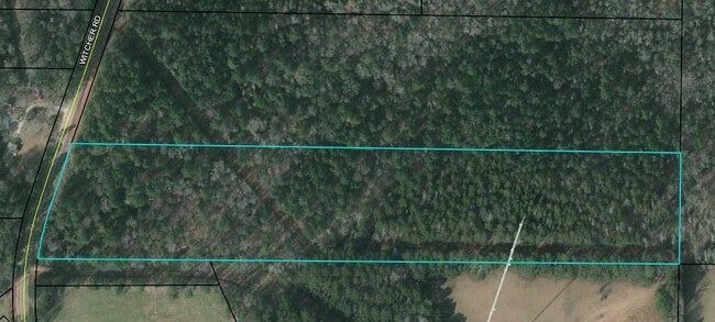
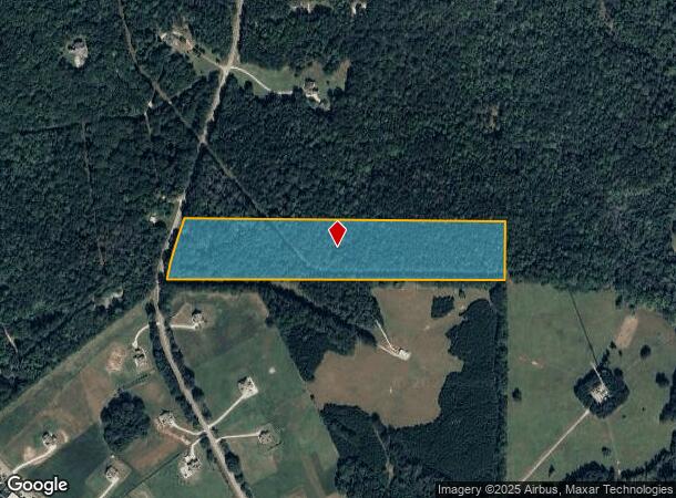
This Property Is For Sale
NEARBY LISTINGS FOR SALE OR LEASE
Property Detail
Witcher Rd
Atlanta-Sandy Springs-Roswell, GA
Coweta
061-5100-003B
Georgia
Residentialnec
14.23 AC
X
Fayette/Coweta County
13077C0140D
Atlanta
DEMOGRAPHICS near Witcher Rd
1 Mile
3 Mile
5 Mile
2024 Total Population
860
17,710
49,464
2029 Population
954
19,635
54,977
Pop Growth 2024-2029
+ 10.93%
+ 10.87%
+ 11.15%
Average Age
40
40
39
2024 Total Households
299
6,537
18,875
HH Growth 2024-2029
+ 11.04%
+ 10.94%
+ 11.20%
Median Household Inc
$62,368
$73,743
$69,796
Avg Household Size
2.70
2.60
2.50
2024 Avg HH Vehicles
2.00
2.00
2.00
Median Home Value
$178,688
$227,051
$250,667
Median Year Built
1985
1985
1991
Nearby Places
Map Layers
Map Styles
 Street
 Aerial
- Restaurants
- Banks
- Shops
- Fitness
- Groceries
PUBLIC TRANSPORTATION
AIRPORT
Hartsfield - Jackson Atlanta International
DRIVE
WALK
Distance
Hartsfield - Jackson Atlanta International
49 min
35.6 mi
Freight Ports
Port of Panama City
DRIVE
WALK
Distance
Port of Panama City
320 min
258.7 mi
Nearby Properties
Address
Land Use
TOTAL SIZE
Lot Size
Zoning
Address
Land Use
TOTAL SIZE
Lot Size
Zoning
136,343 SF
19.77 AC
R2
Address
Land Use
TOTAL SIZE
Lot Size
Zoning
71,484 SF
45.43 AC
R1
Address
Land Use
TOTAL SIZE
Lot Size
Zoning
128,510 SF
25.10 AC
R1
Address
Land Use
TOTAL SIZE
Lot Size
Zoning
79,486 SF
6.13 AC
PS
Address
Land Use
TOTAL SIZE
Lot Size
Zoning
95,483 SF
16.09 AC
R1
Address
Land Use
TOTAL SIZE
Lot Size
Zoning
63,754 SF
15 AC
R1
Address
Land Use
TOTAL SIZE
Lot Size
Zoning
69,685 SF
4.93 AC
R2
Address
Land Use
TOTAL SIZE
Lot Size
Zoning
44,029 SF
78.69 AC
PS
Address
Land Use
TOTAL SIZE
Lot Size
Zoning
151,532 SF
12.25 AC
R1
Address
Land Use
TOTAL SIZE
Lot Size
Zoning
86,796 SF
22.04 AC
C
Address
Land Use
TOTAL SIZE
Lot Size
Zoning
50,722 SF
10.80 AC
R1
Address
Land Use
TOTAL SIZE
Lot Size
Zoning
56,715 SF
12 AC
R1
Address
Land Use
TOTAL SIZE
Lot Size
Zoning
53,250 SF
11.15 AC
R1
Address
Land Use
TOTAL SIZE
Lot Size
Zoning
28,188 SF
10.73 AC
M
Address
Land Use
TOTAL SIZE
Lot Size
Zoning
43,542 SF
5.90 AC
C1
Address
Land Use
TOTAL SIZE
Lot Size
Zoning
135,965 SF
41.37 AC
PS
Address
Land Use
TOTAL SIZE
Lot Size
Zoning
38,987 SF
7.40 AC
R1
Address
Land Use
TOTAL SIZE
Lot Size
Zoning
50,124 SF
8.78 AC
001
Address
Land Use
TOTAL SIZE
Lot Size
Zoning
199.99 AC
R1
Address
Land Use
TOTAL SIZE
Lot Size
Zoning
73,579 SF
6.53 AC
C2
Address
Land Use
TOTAL SIZE
Lot Size
Zoning
44,014 SF
9.90 AC
C2
Address
Land Use
TOTAL SIZE
Lot Size
Zoning
46,610 SF
5.60 AC
R2
Address
Land Use
TOTAL SIZE
Lot Size
Zoning
43,198 SF
14.53 AC
R1
Address
Land Use
TOTAL SIZE
Lot Size
Zoning
42,904 SF
6 AC
R1S
Address
Land Use
TOTAL SIZE
Lot Size
Zoning
23,290 SF
5.37 AC
PS
Address
Land Use
TOTAL SIZE
Lot Size
Zoning
441,820 SF
37 AC
M
Address
Land Use
TOTAL SIZE
Lot Size
Zoning
35.49 AC
R1
Address
Land Use
TOTAL SIZE
Lot Size
Zoning
25,732 SF
34.03 AC
R1
Address
Land Use
TOTAL SIZE
Lot Size
Zoning
24,950 SF
7.82 AC
R1
Address
Land Use
TOTAL SIZE
Lot Size
Zoning
22,773 SF
23.79 AC
M
The World's #1 Commercial Real Estate Marketplace
Connect with us
© 2026 CoStar Group
The information above has been obtained from sources believed reliable. While we do not doubt its accuracy we have not verified it and make no guarantee, warranty or representation about it. It is your responsibility to independently confirm its accuracy and completeness. Any projections, opinions, assumptions, or estimates used are for example only and do not represent the current or future performance of the property. The value of this transaction to you depends on tax and other factors which should be evaluated by your tax, financial, and legal advisors. You and your advisors should conduct a careful, independent investigation of the property to determine to your satisfaction the suitability of the property for your needs.