Property Record
1009 N Hawks Perch St, Nixa, MO 65714
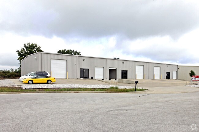
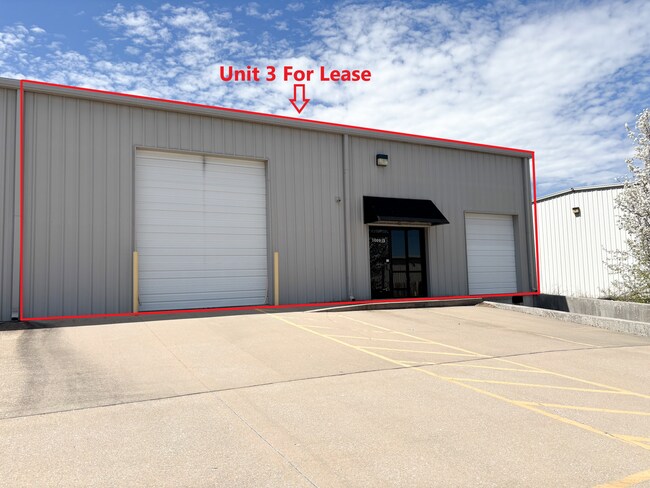
Property Detail
1009 N Hawks Perch St
Springfield, MO
LOT 11 NIXA INDUSTRIAL PARK 4TH ADD PH 4
10-0.1-11-000-000-022.037
Christian
Commercialnec
Missouri
B and X Area of moderate flood hazard, usually the area between the limits of the 100-year and 500-year floods.
11
2024
1.36 AC
2025
West Christian County
020202
Springfield
10,840 SF
NEARBY LISTINGS FOR SALE OR LEASE
DEMOGRAPHICS near 1009 N Hawks Perch St
1 mile
3 mile
5 mile
2025 Total Population
2,995
32,400
66,556
2030 Population
3,188
34,388
69,905
Pop Growth 2025-2030
+ 6.44%
+ 6.14%
+ 5.03%
Average Age
45
40
40
2025 Total Households
1,168
12,372
25,549
HH Growth 2025-2030
+ 6.34%
+ 6.14%
+ 5.05%
Median Household Inc
$86,452
$81,855
$86,862
Avg Household Size
2.50
2.60
2.60
2025 Avg HH Vehicles
2.00
2.00
2.00
Median Home Value
$325,699
$302,832
$329,341
Median Year Built
1995
1997
1998
Nearby Places
Map Layers
Map Styles
 Street
 Aerial
Layers
 Traffic
 Biking
Places
Listings with unknown addresses are not visible on the map
- Restaurants
- Banks
- Shops
- Fitness
- Groceries
PUBLIC TRANSPORTATION
AIRPORT
Springfield-Branson Ntl
Drive
Walk
Distance
Springfield-Branson Ntl
39 min
20.5 mi
SALE & LEASE HISTORY
LISTING DATE
SALE/LEASE

Apr 01, 2025
For Lease
Nearby Properties
Address
Land Use
TOTAL SIZE
Lot Size
Zoning
Address
Land Use
TOTAL SIZE
Lot Size
Zoning
6,164 SF
62.43 AC
Address
Land Use
TOTAL SIZE
Lot Size
Zoning
192,607 SF
26.20 AC
Address
Land Use
TOTAL SIZE
Lot Size
Zoning
5,310 SF
12.27 AC
Address
Land Use
TOTAL SIZE
Lot Size
Zoning
5,360 SF
9.71 AC
Address
Land Use
TOTAL SIZE
Lot Size
Zoning
68,882 SF
39.87 AC
Address
Land Use
TOTAL SIZE
Lot Size
Zoning
30,049 SF
5.01 AC
Address
Land Use
TOTAL SIZE
Lot Size
Zoning
21,597 SF
18 AC
Address
Land Use
TOTAL SIZE
Lot Size
Zoning
4,894 SF
10.80 AC
Address
Land Use
TOTAL SIZE
Lot Size
Zoning
9,841 SF
7.17 AC
Address
Land Use
TOTAL SIZE
Lot Size
Zoning
92,462 SF
19.78 AC
Address
Land Use
TOTAL SIZE
Lot Size
Zoning
1,640 SF
24.20 AC
Address
Land Use
TOTAL SIZE
Lot Size
Zoning
6,875 SF
6.56 AC
Address
Land Use
TOTAL SIZE
Lot Size
Zoning
54,519 SF
18.56 AC
Address
Land Use
TOTAL SIZE
Lot Size
Zoning
53,597 SF
39.40 AC
Address
Land Use
TOTAL SIZE
Lot Size
Zoning
11,830 SF
10 AC
Address
Land Use
TOTAL SIZE
Lot Size
Zoning
15,785 SF
3.99 AC
Address
Land Use
TOTAL SIZE
Lot Size
Zoning
11,600 SF
18.75 AC
Address
Land Use
TOTAL SIZE
Lot Size
Zoning
1,768 SF
9.46 AC
Address
Land Use
TOTAL SIZE
Lot Size
Zoning
18,055 SF
7 AC
Address
Land Use
TOTAL SIZE
Lot Size
Zoning
6,006 SF
9.93 AC
Address
Land Use
TOTAL SIZE
Lot Size
Zoning
25,749 SF
39.26 AC
Address
Land Use
TOTAL SIZE
Lot Size
Zoning
2,400 SF
8.51 AC
Address
Land Use
TOTAL SIZE
Lot Size
Zoning
9,483 SF
4.71 AC
Address
Land Use
TOTAL SIZE
Lot Size
Zoning
13,940 SF
3.43 AC
Address
Land Use
TOTAL SIZE
Lot Size
Zoning
6,176 SF
5.45 AC
Address
Land Use
TOTAL SIZE
Lot Size
Zoning
6,620 SF
10 AC
Address
Land Use
TOTAL SIZE
Lot Size
Zoning
6,176 SF
1.74 AC
Address
Land Use
TOTAL SIZE
Lot Size
Zoning
7,168 SF
4.54 AC
Address
Land Use
TOTAL SIZE
Lot Size
Zoning
3,935 SF
3 AC
The World's #1 Commercial Real Estate Marketplace
Connect with us
© 2026 CoStar Group
The information above has been obtained from sources believed reliable. While we do not doubt its accuracy we have not verified it and make no guarantee, warranty or representation about it. It is your responsibility to independently confirm its accuracy and completeness. Any projections, opinions, assumptions, or estimates used are for example only and do not represent the current or future performance of the property. The value of this transaction to you depends on tax and other factors which should be evaluated by your tax, financial, and legal advisors. You and your advisors should conduct a careful, independent investigation of the property to determine to your satisfaction the suitability of the property for your needs.