Property Record
0000, Los Angeles, CA 00000

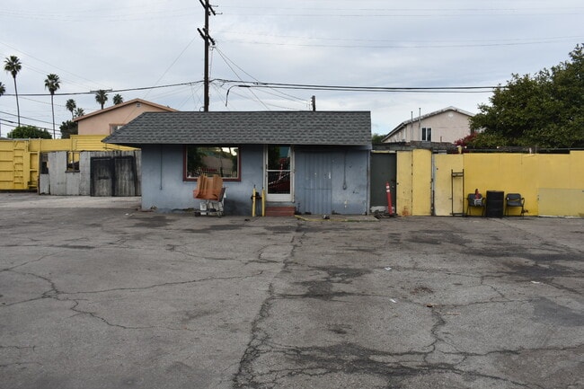
Property Detail
0000
Los Angeles-Long Beach-Glendale, CA
TRACT NO 6534 LOT 31
6029-032-010
LOS ANGELES
Commercialacreage
California
LAC2
31
B and X Area of moderate flood hazard, usually the area between the limits of the 100-year and 500-year floods.
0.12 AC
2024
Mid-Cities
2025
Los Angeles
239802
NEARBY LISTINGS FOR SALE OR LEASE
DEMOGRAPHICS near 0000
1 mile
3 mile
5 mile
2025 Total Population
61,477
465,023
1,030,576
2030 Population
60,457
456,244
1,012,181
Pop Growth 2025-2030
(1.66%)
(1.89%)
(1.78%)
Average Age
34
36
37
2025 Total Households
14,667
119,171
276,757
HH Growth 2025-2030
(1.97%)
(2.18%)
(2.01%)
Median Household Inc
$57,989
$58,657
$62,404
Avg Household Size
3.90
3.70
3.50
2025 Avg HH Vehicles
2.00
2.00
2.00
Median Home Value
$630,949
$662,163
$695,538
Median Year Built
1950
1951
1953
Nearby Places
Map Layers
Map Styles
 Street
 Aerial
Layers
 Traffic
 Biking
Places
Listings with unknown addresses are not visible on the map
- Restaurants
- Banks
- Shops
- Fitness
- Groceries
PUBLIC TRANSPORTATION
COMMUTER RAIL
Los Angeles (Coast Starlight - Amtrak, Pacific Surfliner - Amtrak, Southwest Chief - Amtrak, Texas Eagle - Amtrak)
Drive
Walk
Distance
Los Angeles (Coast Starlight - Amtrak, Pacific Surfliner - Amtrak, Southwest Chief - Amtrak, Texas Eagle - Amtrak)
13 min
9.5 mi
Union Station (91 Line - Southern California Regional Rail Authority (Metrolink), Antelope Valley Line - Southern California Regional Rail Authority (Metrolink), Orange County Line - Southern California Regional Rail Authority (Metrolink), Riverside Line - Southern California Regional Rail Authority (Metrolink), San Bernardino Line - Southern California Regional Rail Authority (Metrolink), Ventura County Line - Southern California Regional Rail Authority (Metrolink))
Drive
Walk
Distance
Union Station (91 Line - Southern California Regional Rail Authority (Metrolink), Antelope Valley Line - Southern California Regional Rail Authority (Metrolink), Orange County Line - Southern California Regional Rail Authority (Metrolink), Riverside Line - Southern California Regional Rail Authority (Metrolink), San Bernardino Line - Southern California Regional Rail Authority (Metrolink), Ventura County Line - Southern California Regional Rail Authority (Metrolink))
16 min
9.7 mi
AIRPORT
Los Angeles International
Drive
Walk
Distance
Los Angeles International
17 min
9.3 mi
Long Beach (Daugherty Field)
Drive
Walk
Distance
Long Beach (Daugherty Field)
23 min
17.0 mi
Bob Hope
Drive
Walk
Distance
Bob Hope
33 min
24.7 mi
Freight Ports
Port of Long Beach
Drive
Walk
Distance
Port of Long Beach
26 min
18.9 mi
SALE & LEASE HISTORY
LISTING DATE
SALE/LEASE

Dec 18, 2025
For Lease
Nearby Properties
Address
Land Use
TOTAL SIZE
Lot Size
Zoning
Address
Land Use
TOTAL SIZE
Lot Size
Zoning
108,598 SF
15.93 AC
LCC3*
Address
Land Use
TOTAL SIZE
Lot Size
Zoning
Address
Land Use
TOTAL SIZE
Lot Size
Zoning
116,728 SF
0.86 AC
HPCP*
Address
Land Use
TOTAL SIZE
Lot Size
Zoning
63,922 SF
1.82 AC
LCA16000*
Address
Land Use
TOTAL SIZE
Lot Size
Zoning
261,540 SF
10.85 AC
VEM*
Address
Land Use
TOTAL SIZE
Lot Size
Zoning
127,484 SF
7.33 AC
LAM2
Address
Land Use
TOTAL SIZE
Lot Size
Zoning
81,735 SF
4.10 AC
LAR4
Address
Land Use
TOTAL SIZE
Lot Size
Zoning
104,291 SF
7.35 AC
LAR3
Address
Land Use
TOTAL SIZE
Lot Size
Zoning
134,514 SF
1.94 AC
LCM2*
Address
Land Use
TOTAL SIZE
Lot Size
Zoning
103,656 SF
6.98 AC
LCM1
Address
Land Use
TOTAL SIZE
Lot Size
Zoning
121,632 SF
1.09 AC
HPCN*
Address
Land Use
TOTAL SIZE
Lot Size
Zoning
293,886 SF
4.98 AC
SGM3
Address
Land Use
TOTAL SIZE
Lot Size
Zoning
102,719 SF
5.50 AC
LARD2
Address
Land Use
TOTAL SIZE
Lot Size
Zoning
402,118 SF
9.39 AC
LAC2
Address
Land Use
TOTAL SIZE
Lot Size
Zoning
111,213 SF
12.04 AC
LAR4
Address
Land Use
TOTAL SIZE
Lot Size
Zoning
188,030 SF
3.09 AC
LAR5
Address
Land Use
TOTAL SIZE
Lot Size
Zoning
103,896 SF
5.06 AC
VEM*
Address
Land Use
TOTAL SIZE
Lot Size
Zoning
101,562 SF
7.53 AC
LAR3
Address
Land Use
TOTAL SIZE
Lot Size
Zoning
52,331 SF
4.17 AC
SG
Address
Land Use
TOTAL SIZE
Lot Size
Zoning
102,260 SF
16.84 AC
LAR4
Address
Land Use
TOTAL SIZE
Lot Size
Zoning
90,887 SF
0.94 AC
LCR320U*
Address
Land Use
TOTAL SIZE
Lot Size
Zoning
152,151 SF
3.59 AC
LCM2*
Address
Land Use
TOTAL SIZE
Lot Size
Zoning
86,905 SF
4.63 AC
VEM*
Address
Land Use
TOTAL SIZE
Lot Size
Zoning
589,061 SF
19.32 AC
SGM3
Address
Land Use
TOTAL SIZE
Lot Size
Zoning
112,578 SF
4.64 AC
VEM*
Address
Land Use
TOTAL SIZE
Lot Size
Zoning
165,404 SF
1.12 AC
HPDTSP
Address
Land Use
TOTAL SIZE
Lot Size
Zoning
113,733 SF
1.59 AC
LAM2
Address
Land Use
TOTAL SIZE
Lot Size
Zoning
38,567 SF
1.11 AC
LAR3
Address
Land Use
TOTAL SIZE
Lot Size
Zoning
40,065 SF
1.24 AC
LAC2
Address
Land Use
TOTAL SIZE
Lot Size
Zoning
73,360 SF
0.65 AC
HPCG-R3
The World's #1 Commercial Real Estate Marketplace
Connect with us
© 2026 CoStar Group
The information above has been obtained from sources believed reliable. While we do not doubt its accuracy we have not verified it and make no guarantee, warranty or representation about it. It is your responsibility to independently confirm its accuracy and completeness. Any projections, opinions, assumptions, or estimates used are for example only and do not represent the current or future performance of the property. The value of this transaction to you depends on tax and other factors which should be evaluated by your tax, financial, and legal advisors. You and your advisors should conduct a careful, independent investigation of the property to determine to your satisfaction the suitability of the property for your needs.