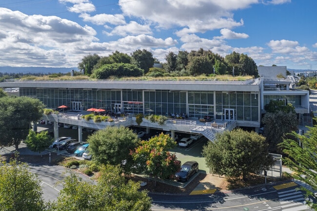
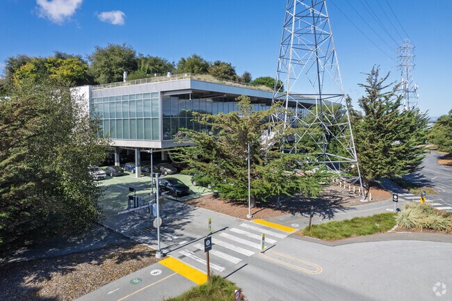
Property Record
1 Facebook Way, Menlo Park, CA 94025

NEARBY LISTINGS FOR SALE OR LEASE
Property Detail
1 Facebook Way
055-260-290
22.092 AC MOL OF LAND INCLUDES PAR A OF LLA 2013-066476 AND 2,720 SQFT OF LAND ADJ TO EB OF ST ROUTE 84
Officebuilding
San Mateo
AE
California
06081C0306F
22.07 AC
2024
Menlo Park
2025
San Francisco
611700
San Francisco-Redwood City-South San Francisco, CA
DEMOGRAPHICS near 1 Facebook Way
1 Mile
3 Mile
5 Mile
2024 Total Population
13,511
87,054
222,685
2029 Population
12,696
83,149
214,224
Pop Growth 2024-2029
(6.03%)
(4.49%)
(3.80%)
Average Age
37
39
39
2024 Total Households
3,366
28,846
75,677
HH Growth 2024-2029
(6.42%)
(4.40%)
(3.77%)
Median Household Inc
$108,259
$136,335
$141,837
Avg Household Size
3.60
2.80
2.60
2024 Avg HH Vehicles
3.00
2.00
2.00
Median Home Value
$1,043,851
$1,118,976
$1,130,104
Median Year Built
1955
1960
1965
Nearby Places
Map Layers
Map Styles
 Street
 Aerial
- Restaurants
- Banks
- Shops
- Fitness
- Groceries
PUBLIC TRANSPORTATION
COMMUTER RAIL
Palo Alto (Caltrain - Caltrain (Caltrain), Express - Caltrain (Caltrain), Limited - Caltrain (Caltrain), Local Weekday - Caltrain (Caltrain), Local Weekend - Caltrain (Caltrain))
DRIVE
WALK
Distance
Palo Alto (Caltrain - Caltrain (Caltrain), Express - Caltrain (Caltrain), Limited - Caltrain (Caltrain), Local Weekday - Caltrain (Caltrain), Local Weekend - Caltrain (Caltrain))
10 min
3.6 mi
Menlo Park (Caltrain - Caltrain (Caltrain), Limited - Caltrain (Caltrain), Local Weekday - Caltrain (Caltrain), Local Weekend - Caltrain (Caltrain))
DRIVE
WALK
Distance
Menlo Park (Caltrain - Caltrain (Caltrain), Limited - Caltrain (Caltrain), Local Weekday - Caltrain (Caltrain), Local Weekend - Caltrain (Caltrain))
10 min
3.9 mi
AIRPORT
Norman Y Mineta San Jose International
DRIVE
WALK
Distance
Norman Y Mineta San Jose International
23 min
16.7 mi
San Francisco International
DRIVE
WALK
Distance
San Francisco International
26 min
18.6 mi
Metro Oakland International
DRIVE
WALK
Distance
Metro Oakland International
35 min
26.1 mi
Freight Ports
Port of Redwood City
DRIVE
WALK
Distance
Port of Redwood City
11 min
5.4 mi
Nearby Properties
Address
Land Use
TOTAL SIZE
Lot Size
Zoning
Address
Land Use
TOTAL SIZE
Lot Size
Zoning
719,052 SF
56.03 AC
Address
Land Use
TOTAL SIZE
Lot Size
Zoning
999,999 SF
56.91 AC
Address
Land Use
TOTAL SIZE
Lot Size
Zoning
1,395,540 SF
51.72 AC
C3
Address
Land Use
TOTAL SIZE
Lot Size
Zoning
Address
Land Use
TOTAL SIZE
Lot Size
Zoning
520,988 SF
8.88 AC
Address
Land Use
TOTAL SIZE
Lot Size
Zoning
373,238 SF
7.94 AC
Address
Land Use
TOTAL SIZE
Lot Size
Zoning
Address
Land Use
TOTAL SIZE
Lot Size
Zoning
528,437 SF
9.69 AC
Address
Land Use
TOTAL SIZE
Lot Size
Zoning
210,000 SF
10.79 AC
Address
Land Use
TOTAL SIZE
Lot Size
Zoning
247,567 SF
3.52 AC
Address
Land Use
TOTAL SIZE
Lot Size
Zoning
212,924 SF
1.83 AC
Address
Land Use
TOTAL SIZE
Lot Size
Zoning
368,000 SF
11.32 AC
Address
Land Use
TOTAL SIZE
Lot Size
Zoning
164,853 SF
3.89 AC
Address
Land Use
TOTAL SIZE
Lot Size
Zoning
145,617 SF
8.24 AC
EA00C1
Address
Land Use
TOTAL SIZE
Lot Size
Zoning
190,389 SF
11.20 AC
M20000
Address
Land Use
TOTAL SIZE
Lot Size
Zoning
143,429 SF
2.12 AC
Address
Land Use
TOTAL SIZE
Lot Size
Zoning
149,700 SF
2.28 AC
Address
Land Use
TOTAL SIZE
Lot Size
Zoning
222,234 SF
6.39 AC
Address
Land Use
TOTAL SIZE
Lot Size
Zoning
Address
Land Use
TOTAL SIZE
Lot Size
Zoning
16.43 AC
Address
Land Use
TOTAL SIZE
Lot Size
Zoning
190,000 SF
3.37 AC
Address
Land Use
TOTAL SIZE
Lot Size
Zoning
171,563 SF
3.57 AC
Address
Land Use
TOTAL SIZE
Lot Size
Zoning
2,024 SF
1.38 AC
Address
Land Use
TOTAL SIZE
Lot Size
Zoning
68,488 SF
1.38 AC
M20000
Address
Land Use
TOTAL SIZE
Lot Size
Zoning
170,495 SF
7.15 AC
Address
Land Use
TOTAL SIZE
Lot Size
Zoning
259,586 SF
17.92 AC
LMD
Address
Land Use
TOTAL SIZE
Lot Size
Zoning
102,690 SF
6.71 AC
Address
Land Use
TOTAL SIZE
Lot Size
Zoning
129,899 SF
1.77 AC
Address
Land Use
TOTAL SIZE
Lot Size
Zoning
129,899 SF
1.47 AC
The World's #1 Commercial Real Estate Marketplace
Connect with us
© 2025 CoStar Group
The information above has been obtained from sources believed reliable. While we do not doubt its accuracy we have not verified it and make no guarantee, warranty or representation about it. It is your responsibility to independently confirm its accuracy and completeness. Any projections, opinions, assumptions, or estimates used are for example only and do not represent the current or future performance of the property. The value of this transaction to you depends on tax and other factors which should be evaluated by your tax, financial, and legal advisors. You and your advisors should conduct a careful, independent investigation of the property to determine to your satisfaction the suitability of the property for your needs.