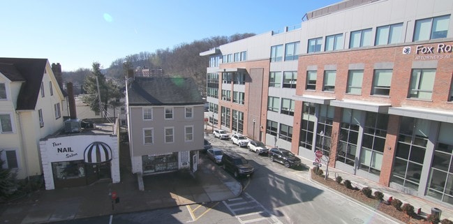
Property Record
1 Maple Ave, Morristown, NJ 07960

Property Detail
1 Maple Ave
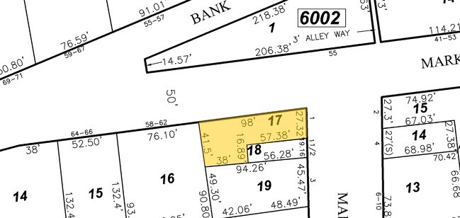
24-06005-0000-00017
Morris
Commercialnec
New Jersey
ORC
17
2024
0.08 AC
2025
Morristown Region
043700
Northern New Jersey
3,936 SF
Newark, NJ
NEARBY LISTINGS FOR SALE OR LEASE
-
-
No Photo
-
-
-
-
-
-
View all Morristown listings for sale on LoopNet.com
DEMOGRAPHICS near 1 Maple Ave
1 mile
3 mile
5 mile
2024 Total Population
19,667
57,210
121,868
2029 Population
20,093
58,626
125,064
Pop Growth 2024-2029
+ 2.17%
+ 2.48%
+ 2.62%
Average Age
38
41
42
2024 Total Households
8,366
22,552
45,222
HH Growth 2024-2029
+ 2.56%
+ 2.67%
+ 2.77%
Median Household Inc
$124,075
$148,755
$157,309
Avg Household Size
2.20
2.40
2.50
2024 Avg HH Vehicles
2.00
2.00
2.00
Median Home Value
$655,037
$716,419
$731,108
Median Year Built
1962
1967
1970
Nearby Places
Map Layers
Map Styles
 Street
 Aerial
Transit
 Traffic
 Biking
Places
Listings with unknown addresses are not visible on the map
- Restaurants
- Banks
- Shops
- Fitness
- Groceries
PUBLIC TRANSPORTATION
TRANSIT/SUBWAY
Morristown (Morris & Essex Morristown Line - NJ Transit Commuter Rail (NJ Transit))
Drive
Walk
Distance
Morristown (Morris & Essex Morristown Line - NJ Transit Commuter Rail (NJ Transit))
2 min
11 min
0.6 mi
COMMUTER RAIL
Morristown (Morris & Essex Morristown Line - NJ Transit Commuter Rail (NJ Transit))
Drive
Walk
Distance
Morristown (Morris & Essex Morristown Line - NJ Transit Commuter Rail (NJ Transit))
2 min
11 min
0.6 mi
Morris Plains (Morris & Essex Morristown Line - NJ Transit Commuter Rail (NJ Transit))
Drive
Walk
Distance
Morris Plains (Morris & Essex Morristown Line - NJ Transit Commuter Rail (NJ Transit))
6 min
2.6 mi
AIRPORT
Newark Liberty International
Drive
Walk
Distance
Newark Liberty International
29 min
22.0 mi
LaGuardia
Drive
Walk
Distance
LaGuardia
62 min
46.0 mi
Freight Ports
Maher Terminal
Drive
Walk
Distance
Maher Terminal
33 min
22.6 mi
SALE & LEASE HISTORY
LISTING DATE
SALE/LEASE

Feb 15, 2019
For Sale
Nearby Properties
Address
Land Use
TOTAL SIZE
Lot Size
Zoning
Address
Land Use
TOTAL SIZE
Lot Size
Zoning
596 SF
64.81 AC
OBRL
Address
Land Use
TOTAL SIZE
Lot Size
Zoning
23.01 AC
R-2
Address
Land Use
TOTAL SIZE
Lot Size
Zoning
72,698 SF
133.64 AC
U
Address
Land Use
TOTAL SIZE
Lot Size
Zoning
1.55 AC
Address
Land Use
TOTAL SIZE
Lot Size
Zoning
2.82 AC
Address
Land Use
TOTAL SIZE
Lot Size
Zoning
13,428 SF
108.84 AC
OSGU
Address
Land Use
TOTAL SIZE
Lot Size
Zoning
396,029 SF
40.08 AC
OL40
Address
Land Use
TOTAL SIZE
Lot Size
Zoning
10.94 AC
Address
Land Use
TOTAL SIZE
Lot Size
Zoning
8.64 AC
RG
Address
Land Use
TOTAL SIZE
Lot Size
Zoning
Address
Land Use
TOTAL SIZE
Lot Size
Zoning
18.42 AC
RM
Address
Land Use
TOTAL SIZE
Lot Size
Zoning
475,100 SF
38 AC
OL40
Address
Land Use
TOTAL SIZE
Lot Size
Zoning
0.36 AC
UR
Address
Land Use
TOTAL SIZE
Lot Size
Zoning
10.42 AC
Address
Land Use
TOTAL SIZE
Lot Size
Zoning
34.13 AC
OB
Address
Land Use
TOTAL SIZE
Lot Size
Zoning
3.13 AC
CBD
Address
Land Use
TOTAL SIZE
Lot Size
Zoning
14.50 AC
RG
Address
Land Use
TOTAL SIZE
Lot Size
Zoning
38.86 AC
L
Address
Land Use
TOTAL SIZE
Lot Size
Zoning
0.57 AC
CBD
Address
Land Use
TOTAL SIZE
Lot Size
Zoning
0.41 AC
UR
Address
Land Use
TOTAL SIZE
Lot Size
Zoning
0.35 AC
UR
Address
Land Use
TOTAL SIZE
Lot Size
Zoning
1.71 AC
Address
Land Use
TOTAL SIZE
Lot Size
Zoning
322,575 SF
32.28 AC
OL40
Address
Land Use
TOTAL SIZE
Lot Size
Zoning
6.56 AC
OB
Address
Land Use
TOTAL SIZE
Lot Size
Zoning
25.14 AC
I-B3
Address
Land Use
TOTAL SIZE
Lot Size
Zoning
2,380 SF
1.32 AC
RC
Address
Land Use
TOTAL SIZE
Lot Size
Zoning
19.35 AC
0L40
Address
Land Use
TOTAL SIZE
Lot Size
Zoning
2.70 AC
Address
Land Use
TOTAL SIZE
Lot Size
Zoning
200,360 SF
16.20 AC
OL-5
Address
Land Use
TOTAL SIZE
Lot Size
Zoning
0.76 AC
UR
The World's #1 Commercial Real Estate Marketplace
Connect with us
© 2026 CoStar Group
The information above has been obtained from sources believed reliable. While we do not doubt its accuracy we have not verified it and make no guarantee, warranty or representation about it. It is your responsibility to independently confirm its accuracy and completeness. Any projections, opinions, assumptions, or estimates used are for example only and do not represent the current or future performance of the property. The value of this transaction to you depends on tax and other factors which should be evaluated by your tax, financial, and legal advisors. You and your advisors should conduct a careful, independent investigation of the property to determine to your satisfaction the suitability of the property for your needs.