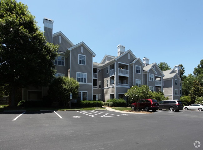
Property Record
100 Copperline Dr, Chapel Hill, NC 27516
Save to a Folder
{{folder.Name}}
{{folder.ListingIds.length}} Properties
{{folder.ListingIds.length}} Property
Create a New Folder
Property Detail
100 Copperline Dr
9787161113
2B-2C SOUTHERN VILLAGE APARTMENTS & 2A-R SOUTHERN
Multifamilydwelling
ORANGE
B and X Area of moderate flood hazard, usually the area between the limits of the 100-year and 500-year floods.
North Carolina
2025
9.81 AC
2025
Southern Village
012202
Raleigh/Durham
18,410 SF
Durham-Chapel Hill, NC
NEARBY LISTINGS FOR SALE OR LEASE
DEMOGRAPHICS near 100 Copperline Dr
1 mile
3 mile
5 mile
2025 Total Population
4,760
54,061
99,339
2030 Population
4,827
56,202
103,585
Pop Growth 2025-2030
+ 1.41%
+ 3.96%
+ 4.27%
Average Age
40
35
38
2025 Total Households
1,861
19,641
38,768
HH Growth 2025-2030
+ 1.61%
+ 4.67%
+ 4.76%
Median Household Inc
$157,905
$74,680
$94,612
Avg Household Size
2.50
2.20
2.30
2025 Avg HH Vehicles
2.00
2.00
2.00
Median Home Value
$687,242
$653,818
$641,341
Median Year Built
1994
1988
1990
Nearby Places
Map Layers
Map Styles
 Street
 Aerial
Layers
 Traffic
 Biking
Places
Listings with unknown addresses are not visible on the map
- Restaurants
- Banks
- Shops
- Fitness
- Groceries
PUBLIC TRANSPORTATION
AIRPORT
Raleigh-Durham International
Drive
Walk
Distance
Raleigh-Durham International
31 min
19.1 mi
Freight Ports
Port of Wilmington
Drive
Walk
Distance
Port of Wilmington
191 min
163.3 mi
Nearby Properties
Address
Land Use
TOTAL SIZE
Lot Size
Zoning
Address
Land Use
TOTAL SIZE
Lot Size
Zoning
215,860 SF
12.28 AC
Address
Land Use
TOTAL SIZE
Lot Size
Zoning
264,710 SF
32.50 AC
R1
Address
Land Use
TOTAL SIZE
Lot Size
Zoning
81,191 SF
12.33 AC
OI4
Address
Land Use
TOTAL SIZE
Lot Size
Zoning
55,318 SF
9.05 AC
R4
Address
Land Use
TOTAL SIZE
Lot Size
Zoning
238,990 SF
2.43 AC
Address
Land Use
TOTAL SIZE
Lot Size
Zoning
54,220 SF
41.04 AC
R-1
Address
Land Use
TOTAL SIZE
Lot Size
Zoning
119,585 SF
62.30 AC
Address
Land Use
TOTAL SIZE
Lot Size
Zoning
26,328 SF
13.86 AC
OR3
Address
Land Use
TOTAL SIZE
Lot Size
Zoning
361,420 SF
1.68 AC
Address
Land Use
TOTAL SIZE
Lot Size
Zoning
24,820 SF
1 AC
Address
Land Use
TOTAL SIZE
Lot Size
Zoning
143,750 SF
1.32 AC
OI3OI4
Address
Land Use
TOTAL SIZE
Lot Size
Zoning
174,922 SF
4.59 AC
OI4
Address
Land Use
TOTAL SIZE
Lot Size
Zoning
9,057 SF
19.69 AC
R-1
Address
Land Use
TOTAL SIZE
Lot Size
Zoning
15,916 SF
46.02 AC
R10RSIR
Address
Land Use
TOTAL SIZE
Lot Size
Zoning
12,328 SF
16.37 AC
R75
Address
Land Use
TOTAL SIZE
Lot Size
Zoning
38,514 SF
25.11 AC
R-1
Address
Land Use
TOTAL SIZE
Lot Size
Zoning
22,328 SF
19.48 AC
Address
Land Use
TOTAL SIZE
Lot Size
Zoning
27,537 SF
7.33 AC
R-1
Address
Land Use
TOTAL SIZE
Lot Size
Zoning
82,064 SF
1.41 AC
Address
Land Use
TOTAL SIZE
Lot Size
Zoning
45,320 SF
0.66 AC
TC1TC2
Address
Land Use
TOTAL SIZE
Lot Size
Zoning
71,856 SF
20.37 AC
R10R3
Address
Land Use
TOTAL SIZE
Lot Size
Zoning
12,014 SF
10.38 AC
R75
Address
Land Use
TOTAL SIZE
Lot Size
Zoning
48,690 SF
15.69 AC
OR3R75
Address
Land Use
TOTAL SIZE
Lot Size
Zoning
35,988 SF
14.52 AC
R75
Address
Land Use
TOTAL SIZE
Lot Size
Zoning
86,478 SF
8.60 AC
B1CCT
Address
Land Use
TOTAL SIZE
Lot Size
Zoning
19,584 SF
12.58 AC
R15R3
Address
Land Use
TOTAL SIZE
Lot Size
Zoning
10,764 SF
8.64 AC
M1R75
Address
Land Use
TOTAL SIZE
Lot Size
Zoning
32,268 SF
1.55 AC
OI3OI4
Address
Land Use
TOTAL SIZE
Lot Size
Zoning
57,600 SF
8 AC
R10RSIR
The World's #1 Commercial Real Estate Marketplace
Connect with us
© 2026 CoStar Group
The information above has been obtained from sources believed reliable. While we do not doubt its accuracy we have not verified it and make no guarantee, warranty or representation about it. It is your responsibility to independently confirm its accuracy and completeness. Any projections, opinions, assumptions, or estimates used are for example only and do not represent the current or future performance of the property. The value of this transaction to you depends on tax and other factors which should be evaluated by your tax, financial, and legal advisors. You and your advisors should conduct a careful, independent investigation of the property to determine to your satisfaction the suitability of the property for your needs.