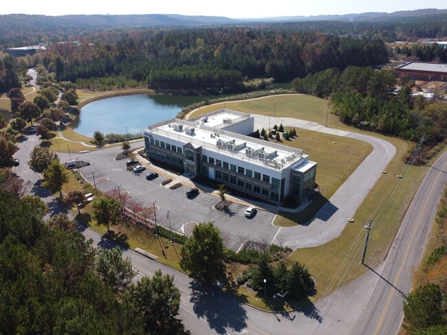
Property Record
100 Lucerne Ln, Birmingham, AL 35211

NEARBY LISTINGS FOR SALE OR LEASE
Property Detail
100 Lucerne Ln
Birmingham, AL
Uss Corporate Park
29-00-32-2-000-001.017
LOT 9 OF USS OXMOOR CORPORATE PARK 37/30
Officebuilding
Jefferson
X
Alabama
01073C0542J
9
2023
5.40 AC
2024
Vulcan/Oxmoor
014304
Birmingham
29,906 SF
DEMOGRAPHICS near 100 Lucerne Ln
1 Mile
3 Mile
5 Mile
2024 Total Population
1,610
33,440
134,435
2029 Population
1,593
32,866
132,926
Pop Growth 2024-2029
(1.06%)
(1.72%)
(1.12%)
Average Age
39
39
40
2024 Total Households
783
14,396
56,340
HH Growth 2024-2029
(1.28%)
(1.85%)
(1.15%)
Median Household Inc
$50,737
$49,103
$48,932
Avg Household Size
2.00
2.30
2.30
2024 Avg HH Vehicles
2.00
2.00
2.00
Median Home Value
$176,886
$165,252
$203,458
Median Year Built
2002
1973
1970
Nearby Places
Map Layers
Map Styles
 Street
 Aerial
- Restaurants
- Banks
- Shops
- Fitness
- Groceries
PUBLIC TRANSPORTATION
COMMUTER RAIL
Birmingham (Crescent - Amtrak)
DRIVE
WALK
Distance
Birmingham (Crescent - Amtrak)
16 min
9.8 mi
AIRPORT
Birmingham-Shuttlesworth International
DRIVE
WALK
Distance
Birmingham-Shuttlesworth International
24 min
14.9 mi
Freight Ports
Port of Mobile
DRIVE
WALK
Distance
Port of Mobile
280 min
255.0 mi
SALE & LEASE HISTORY
LISTING DATE
SALE/LEASE

Nov 15, 2022
For Sale
Nearby Properties
Address
Land Use
TOTAL SIZE
Lot Size
Zoning
Address
Land Use
TOTAL SIZE
Lot Size
Zoning
143,148 SF
15.60 AC
CP
Address
Land Use
TOTAL SIZE
Lot Size
Zoning
242,746 SF
20.96 AC
MXDE
Address
Land Use
TOTAL SIZE
Lot Size
Zoning
334,805 SF
32.50 AC
MXD/
Address
Land Use
TOTAL SIZE
Lot Size
Zoning
209,765 SF
19.20 AC
I-3
Address
Land Use
TOTAL SIZE
Lot Size
Zoning
75,840 SF
20.10 AC
I3
Address
Land Use
TOTAL SIZE
Lot Size
Zoning
197,717 SF
19.02 AC
PUD
Address
Land Use
TOTAL SIZE
Lot Size
Zoning
321,783 SF
19.40 AC
MXD
Address
Land Use
TOTAL SIZE
Lot Size
Zoning
133,396 SF
19 AC
QR6
Address
Land Use
TOTAL SIZE
Lot Size
Zoning
224,184 SF
65.60 AC
I3
Address
Land Use
TOTAL SIZE
Lot Size
Zoning
149,299 SF
15.70 AC
PUD
Address
Land Use
TOTAL SIZE
Lot Size
Zoning
120,238 SF
10 AC
I3
Address
Land Use
TOTAL SIZE
Lot Size
Zoning
517,500 SF
29 AC
I1
Address
Land Use
TOTAL SIZE
Lot Size
Zoning
246,696 SF
13.89 AC
R4
Address
Land Use
TOTAL SIZE
Lot Size
Zoning
118,309 SF
88.50 AC
I3
Address
Land Use
TOTAL SIZE
Lot Size
Zoning
96,446 SF
10 AC
I3
Address
Land Use
TOTAL SIZE
Lot Size
Zoning
222,131 SF
31 AC
I3
Address
Land Use
TOTAL SIZE
Lot Size
Zoning
51,572 SF
494.91 AC
I3
Address
Land Use
TOTAL SIZE
Lot Size
Zoning
202,775 SF
10.40 AC
I3
Address
Land Use
TOTAL SIZE
Lot Size
Zoning
101,251 SF
54 AC
I3
Address
Land Use
TOTAL SIZE
Lot Size
Zoning
72,468 SF
8.70 AC
I3
Address
Land Use
TOTAL SIZE
Lot Size
Zoning
70,575 SF
17.44 AC
I3
Address
Land Use
TOTAL SIZE
Lot Size
Zoning
73,033 SF
15.20 AC
R-6
Address
Land Use
TOTAL SIZE
Lot Size
Zoning
194,260 SF
11.58 AC
CM1A
Address
Land Use
TOTAL SIZE
Lot Size
Zoning
155,030 SF
10.30 AC
R4
Address
Land Use
TOTAL SIZE
Lot Size
Zoning
35,826 SF
3.77 AC
I-3
Address
Land Use
TOTAL SIZE
Lot Size
Zoning
336,653 SF
22.50 AC
CM1
Address
Land Use
TOTAL SIZE
Lot Size
Zoning
191,910 SF
13.88 AC
I3
Address
Land Use
TOTAL SIZE
Lot Size
Zoning
68,191 SF
16.20 AC
I3
The World's #1 Commercial Real Estate Marketplace
Connect with us
© 2026 CoStar Group
The information above has been obtained from sources believed reliable. While we do not doubt its accuracy we have not verified it and make no guarantee, warranty or representation about it. It is your responsibility to independently confirm its accuracy and completeness. Any projections, opinions, assumptions, or estimates used are for example only and do not represent the current or future performance of the property. The value of this transaction to you depends on tax and other factors which should be evaluated by your tax, financial, and legal advisors. You and your advisors should conduct a careful, independent investigation of the property to determine to your satisfaction the suitability of the property for your needs.