Property Record
100 Pineview Dr, Buffalo, NY 14228
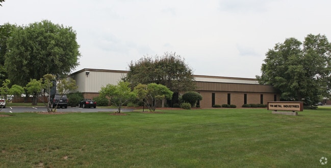

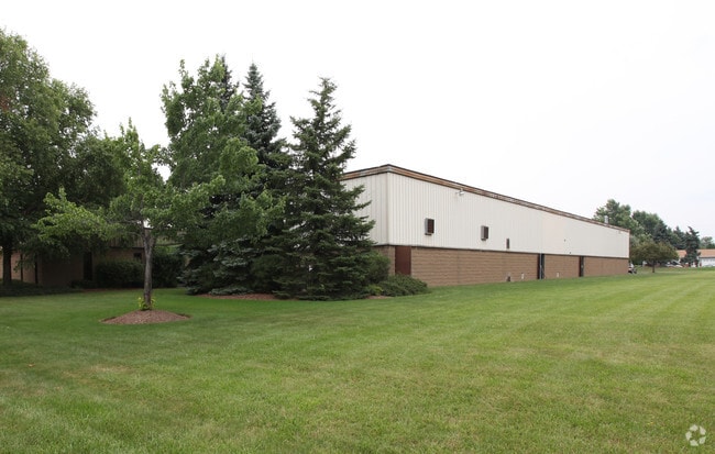
Property Detail
100 Pineview Dr
Buffalo-Cheektowaga, NY
7550 113950
142289-026-200-0004-012-000
Erie
Warehouse
New York
C and X Area of minimal flood hazard, usually depicted on FIRMs as above the 500-year flood level.
12.000
2025
4 AC
2025
North
009107
Buffalo/Niagara Falls
33,351 SF
NEARBY LISTINGS FOR SALE OR LEASE
DEMOGRAPHICS near 100 Pineview Dr
1 mile
3 mile
5 mile
2025 Total Population
5,946
60,228
192,924
2030 Population
5,939
60,439
193,272
Pop Growth 2025-2030
(0.12%)
+ 0.35%
+ 0.18%
Average Age
38
40
42
2025 Total Households
2,451
23,701
80,273
HH Growth 2025-2030
+ 0.24%
+ 0.50%
+ 0.18%
Median Household Inc
$78,538
$76,065
$81,436
Avg Household Size
2.40
2.20
2.20
2025 Avg HH Vehicles
2.00
2.00
2.00
Median Home Value
$278,585
$265,543
$253,291
Median Year Built
1975
1974
1963
Nearby Places
Map Layers
Map Styles
 Street
 Aerial
Transit
 Traffic
 Biking
Places
Listings with unknown addresses are not visible on the map
- Restaurants
- Banks
- Shops
- Fitness
- Groceries
PUBLIC TRANSPORTATION
AIRPORT
Buffalo Niagara International
Drive
Walk
Distance
Buffalo Niagara International
19 min
9.5 mi
Niagara Falls International
Drive
Walk
Distance
Niagara Falls International
18 min
9.7 mi
Freight Ports
Port of Toledo
Drive
Walk
Distance
Port of Toledo
373 min
314.1 mi
Nearby Properties
Address
Land Use
TOTAL SIZE
Lot Size
Zoning
Address
Land Use
TOTAL SIZE
Lot Size
Zoning
2,592,064 SF
1,057.90 AC
Address
Land Use
TOTAL SIZE
Lot Size
Zoning
5,472 SF
70.10 AC
Address
Land Use
TOTAL SIZE
Lot Size
Zoning
2,592 SF
22.40 AC
NCD
Address
Land Use
TOTAL SIZE
Lot Size
Zoning
109,328 SF
12.77 AC
GB
Address
Land Use
TOTAL SIZE
Lot Size
Zoning
409,925 SF
36.41 AC
CTR-5
Address
Land Use
TOTAL SIZE
Lot Size
Zoning
283,706 SF
68.90 AC
Address
Land Use
TOTAL SIZE
Lot Size
Zoning
177,000 SF
14.91 AC
CF
Address
Land Use
TOTAL SIZE
Lot Size
Zoning
41,104 SF
27.52 AC
Address
Land Use
TOTAL SIZE
Lot Size
Zoning
16,065 SF
19.30 AC
Address
Land Use
TOTAL SIZE
Lot Size
Zoning
8,565 SF
22.65 AC
Address
Land Use
TOTAL SIZE
Lot Size
Zoning
12,262 SF
29 AC
MFR-5
Address
Land Use
TOTAL SIZE
Lot Size
Zoning
70,261 SF
14.63 AC
CTR-5
Address
Land Use
TOTAL SIZE
Lot Size
Zoning
213,943 SF
5.50 AC
Address
Land Use
TOTAL SIZE
Lot Size
Zoning
8,842 SF
29.30 AC
Address
Land Use
TOTAL SIZE
Lot Size
Zoning
117,980 SF
14.40 AC
CTR-5
Address
Land Use
TOTAL SIZE
Lot Size
Zoning
197,430 SF
8.20 AC
Address
Land Use
TOTAL SIZE
Lot Size
Zoning
197,430 SF
7.28 AC
Address
Land Use
TOTAL SIZE
Lot Size
Zoning
113,316 SF
12.22 AC
CTR-5
Address
Land Use
TOTAL SIZE
Lot Size
Zoning
83,256 SF
8.01 AC
NCD
Address
Land Use
TOTAL SIZE
Lot Size
Zoning
253,920 SF
22.83 AC
RD
Address
Land Use
TOTAL SIZE
Lot Size
Zoning
6,384 SF
13.30 AC
Address
Land Use
TOTAL SIZE
Lot Size
Zoning
11,248 SF
21.77 AC
MFR-5
Address
Land Use
TOTAL SIZE
Lot Size
Zoning
28,530 SF
30.20 AC
NCD
Address
Land Use
TOTAL SIZE
Lot Size
Zoning
122,669 SF
7.88 AC
CTR-2.5
Address
Land Use
TOTAL SIZE
Lot Size
Zoning
109,461 SF
7.90 AC
CTR-5
Address
Land Use
TOTAL SIZE
Lot Size
Zoning
2,135 SF
11.38 AC
Address
Land Use
TOTAL SIZE
Lot Size
Zoning
132,000 SF
9.40 AC
Address
Land Use
TOTAL SIZE
Lot Size
Zoning
112,256 SF
42.87 AC
00000
Address
Land Use
TOTAL SIZE
Lot Size
Zoning
286,288 SF
50.90 AC
Address
Land Use
TOTAL SIZE
Lot Size
Zoning
228,681 SF
10.31 AC
SC
The World's #1 Commercial Real Estate Marketplace
Connect with us
© 2026 CoStar Group
The information above has been obtained from sources believed reliable. While we do not doubt its accuracy we have not verified it and make no guarantee, warranty or representation about it. It is your responsibility to independently confirm its accuracy and completeness. Any projections, opinions, assumptions, or estimates used are for example only and do not represent the current or future performance of the property. The value of this transaction to you depends on tax and other factors which should be evaluated by your tax, financial, and legal advisors. You and your advisors should conduct a careful, independent investigation of the property to determine to your satisfaction the suitability of the property for your needs.