Property Record
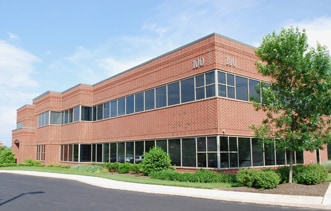
100 Springhouse Dr, Collegeville, PA 19426


Current Lease Availabilities
NEARBY LISTINGS FOR SALE OR LEASE
Property Detail
100 Springhouse Dr
Philadelphia-Camden-Wilmington, PA-NJ-DE-MD
Part/Providence Corporate Cent
61-00-01009-037
4.00 AC
Officebuilding
Montgomery
X
Pennsylvania
42029C0065G
b
2024
4 AC
2025
Norristown/Valley Forge
206104
Philadelphia
32,038 SF
DEMOGRAPHICS near 100 Springhouse Dr
1 Mile
3 Mile
5 Mile
2024 Total Population
3,221
46,103
130,494
2029 Population
3,321
47,091
133,760
Pop Growth 2024-2029
+ 3.10%
+ 2.14%
+ 2.50%
Average Age
41
40
40
2024 Total Households
1,205
15,987
49,040
HH Growth 2024-2029
+ 3.24%
+ 2.25%
+ 2.66%
Median Household Inc
$124,274
$126,783
$108,823
Avg Household Size
2.60
2.60
2.50
2024 Avg HH Vehicles
2.00
2.00
2.00
Median Home Value
$557,361
$437,140
$381,120
Median Year Built
1999
1992
1983
Nearby Places
Map Layers
Map Styles
 Street
 Aerial
- Restaurants
- Banks
- Shops
- Fitness
- Groceries
PUBLIC TRANSPORTATION
COMMUTER RAIL
Main Street (Norristown) (R6 - Southeastern Pennsylvania Transportation Authority Regional Rail (SEPTA Regional Rail))
DRIVE
WALK
Distance
Main Street (Norristown) (R6 - Southeastern Pennsylvania Transportation Authority Regional Rail (SEPTA Regional Rail))
21 min
8.9 mi
Elm Street (Norristown) (R6 - Southeastern Pennsylvania Transportation Authority Regional Rail (SEPTA Regional Rail))
DRIVE
WALK
Distance
Elm Street (Norristown) (R6 - Southeastern Pennsylvania Transportation Authority Regional Rail (SEPTA Regional Rail))
21 min
8.9 mi
AIRPORT
Philadelphia International
DRIVE
WALK
Distance
Philadelphia International
56 min
36.1 mi
Freight Ports
South Jersey Port
DRIVE
WALK
Distance
South Jersey Port
50 min
32.2 mi
Nearby Properties
Address
Land Use
TOTAL SIZE
Lot Size
Zoning
Address
Land Use
TOTAL SIZE
Lot Size
Zoning
975,535 SF
67.40 AC
R2
Address
Land Use
TOTAL SIZE
Lot Size
Zoning
1,113,725 SF
196.05 AC
IO
Address
Land Use
TOTAL SIZE
Lot Size
Zoning
989,814 SF
8.87 AC
IO
Address
Land Use
TOTAL SIZE
Lot Size
Zoning
768,913 SF
81.88 AC
IO
Address
Land Use
TOTAL SIZE
Lot Size
Zoning
1,145,005 SF
149.21 AC
IO
Address
Land Use
TOTAL SIZE
Lot Size
Zoning
463,481 SF
79.65 AC
R1
Address
Land Use
TOTAL SIZE
Lot Size
Zoning
634,096 SF
3.09 AC
IO
Address
Land Use
TOTAL SIZE
Lot Size
Zoning
348,190 SF
68 AC
R1
Address
Land Use
TOTAL SIZE
Lot Size
Zoning
1,470,449 SF
80.02 AC
R1
Address
Land Use
TOTAL SIZE
Lot Size
Zoning
217,154 SF
77.97 AC
R1
Address
Land Use
TOTAL SIZE
Lot Size
Zoning
400,875 SF
32.32 AC
IO
Address
Land Use
TOTAL SIZE
Lot Size
Zoning
420,080 SF
7.33 AC
FCE
Address
Land Use
TOTAL SIZE
Lot Size
Zoning
425,170 SF
23 AC
FCE
Address
Land Use
TOTAL SIZE
Lot Size
Zoning
204,483 SF
25.02 AC
IO
Address
Land Use
TOTAL SIZE
Lot Size
Zoning
347,779 SF
32.59 AC
IN
Address
Land Use
TOTAL SIZE
Lot Size
Zoning
811,455 SF
18.15 AC
M1
Address
Land Use
TOTAL SIZE
Lot Size
Zoning
2,112 SF
5.06 AC
LI/O
Address
Land Use
TOTAL SIZE
Lot Size
Zoning
1,305,221 SF
21.99 AC
M1
Address
Land Use
TOTAL SIZE
Lot Size
Zoning
132,002 SF
0.41 AC
LICO1
Address
Land Use
TOTAL SIZE
Lot Size
Zoning
86,046 SF
12.03 AC
R1
Address
Land Use
TOTAL SIZE
Lot Size
Zoning
102,279 SF
17.15 AC
R1
Address
Land Use
TOTAL SIZE
Lot Size
Zoning
176,130 SF
18.88 AC
C3
Address
Land Use
TOTAL SIZE
Lot Size
Zoning
84,664 SF
14.71 AC
R2
Address
Land Use
TOTAL SIZE
Lot Size
Zoning
86,632 SF
3.88 AC
M1
Address
Land Use
TOTAL SIZE
Lot Size
Zoning
122,036 SF
8.61 AC
M1
Address
Land Use
TOTAL SIZE
Lot Size
Zoning
137,689 SF
21.46 AC
GC
Address
Land Use
TOTAL SIZE
Lot Size
Zoning
180,474 SF
18.26 AC
M1
Address
Land Use
TOTAL SIZE
Lot Size
Zoning
66,894 SF
14.18 AC
R2
Address
Land Use
TOTAL SIZE
Lot Size
Zoning
72,000 SF
3.94 AC
M1
Address
Land Use
TOTAL SIZE
Lot Size
Zoning
125,000 SF
14.39 AC
M1
The World's #1 Commercial Real Estate Marketplace
Connect with us
© 2026 CoStar Group
The information above has been obtained from sources believed reliable. While we do not doubt its accuracy we have not verified it and make no guarantee, warranty or representation about it. It is your responsibility to independently confirm its accuracy and completeness. Any projections, opinions, assumptions, or estimates used are for example only and do not represent the current or future performance of the property. The value of this transaction to you depends on tax and other factors which should be evaluated by your tax, financial, and legal advisors. You and your advisors should conduct a careful, independent investigation of the property to determine to your satisfaction the suitability of the property for your needs.