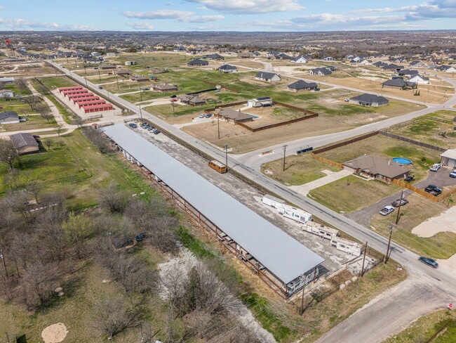
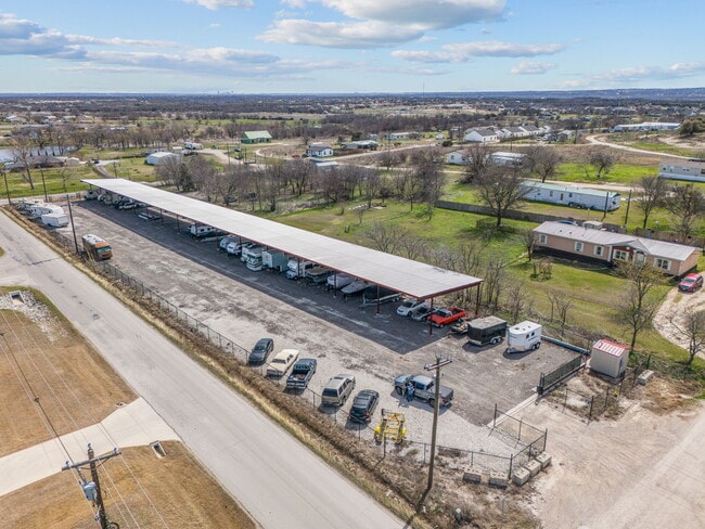
Property Record
100 Veal Station Rd, Weatherford, TX 76085
NEARBY LISTINGS FOR SALE OR LEASE
-
-
View all Weatherford listings for sale on LoopNet.com
Property Detail
100 Veal Station Rd
21427-002-000-00
ACRES: 3.680 LOT: 143R BLK: 4 SUBD: ENCHANTED LAKES PC A-362/37; PC E-798
Commercialnec
Parker
X
Texas
48497C0575D
143r
2024
1.73 AC
2025
Parker County
1404071010
Dallas/Ft Worth
9,480 SF
Dallas-Fort Worth-Arlington, TX
DEMOGRAPHICS near 100 Veal Station Rd
1 Mile
3 Mile
5 Mile
2024 Total Population
1,493
12,570
37,221
2029 Population
1,901
15,865
44,767
Pop Growth 2024-2029
+ 27.33%
+ 26.21%
+ 20.27%
Average Age
42
41
41
2024 Total Households
556
4,520
13,658
HH Growth 2024-2029
+ 26.98%
+ 26.17%
+ 20.00%
Median Household Inc
$84,046
$97,888
$83,932
Avg Household Size
2.60
2.70
2.70
2024 Avg HH Vehicles
3.00
3.00
2.00
Median Home Value
$374,242
$348,436
$301,562
Median Year Built
1998
2004
1996
Nearby Places
Map Layers
Map Styles
 Street
 Aerial
- Restaurants
- Banks
- Shops
- Fitness
- Groceries
SALE & LEASE HISTORY
LISTING DATE
SALE/LEASE

Mar 28, 2025
For Sale
Nearby Properties
Address
Land Use
TOTAL SIZE
Lot Size
Zoning
Address
Land Use
TOTAL SIZE
Lot Size
Zoning
56,296 SF
4.83 AC
Address
Land Use
TOTAL SIZE
Lot Size
Zoning
15,520 SF
5.46 AC
Address
Land Use
TOTAL SIZE
Lot Size
Zoning
54,846 SF
15.80 AC
Address
Land Use
TOTAL SIZE
Lot Size
Zoning
27,800 SF
9 AC
Address
Land Use
TOTAL SIZE
Lot Size
Zoning
25,232 SF
1.84 AC
Address
Land Use
TOTAL SIZE
Lot Size
Zoning
13,281 SF
1 AC
Address
Land Use
TOTAL SIZE
Lot Size
Zoning
19,632 SF
10.05 AC
Address
Land Use
TOTAL SIZE
Lot Size
Zoning
5,195 SF
22.04 AC
Address
Land Use
TOTAL SIZE
Lot Size
Zoning
25,564 SF
3.59 AC
Address
Land Use
TOTAL SIZE
Lot Size
Zoning
52,648 SF
4.08 AC
Address
Land Use
TOTAL SIZE
Lot Size
Zoning
17,517 SF
1.62 AC
Address
Land Use
TOTAL SIZE
Lot Size
Zoning
1,820 SF
7.79 AC
Address
Land Use
TOTAL SIZE
Lot Size
Zoning
25,200 SF
10.16 AC
Address
Land Use
TOTAL SIZE
Lot Size
Zoning
10,024 SF
1.50 AC
Address
Land Use
TOTAL SIZE
Lot Size
Zoning
8,804 SF
6.56 AC
Address
Land Use
TOTAL SIZE
Lot Size
Zoning
1,320 SF
10.89 AC
Address
Land Use
TOTAL SIZE
Lot Size
Zoning
42,240 SF
4.27 AC
Address
Land Use
TOTAL SIZE
Lot Size
Zoning
7,319 SF
1.48 AC
Address
Land Use
TOTAL SIZE
Lot Size
Zoning
6,800 SF
2.02 AC
Address
Land Use
TOTAL SIZE
Lot Size
Zoning
10,857 SF
1.49 AC
Address
Land Use
TOTAL SIZE
Lot Size
Zoning
17,060 SF
3.88 AC
Address
Land Use
TOTAL SIZE
Lot Size
Zoning
6,819 SF
1.54 AC
Address
Land Use
TOTAL SIZE
Lot Size
Zoning
7,500 SF
2.07 AC
Address
Land Use
TOTAL SIZE
Lot Size
Zoning
5,520 SF
3.08 AC
Address
Land Use
TOTAL SIZE
Lot Size
Zoning
9,020 SF
2.04 AC
Address
Land Use
TOTAL SIZE
Lot Size
Zoning
2,790 SF
38.05 AC
Address
Land Use
TOTAL SIZE
Lot Size
Zoning
10,440 SF
0.86 AC
Address
Land Use
TOTAL SIZE
Lot Size
Zoning
2.50 AC
Address
Land Use
TOTAL SIZE
Lot Size
Zoning
4.18 AC
Address
Land Use
TOTAL SIZE
Lot Size
Zoning
9,440 SF
1.71 AC
The World's #1 Commercial Real Estate Marketplace
Connect with us
© 2025 CoStar Group
The information above has been obtained from sources believed reliable. While we do not doubt its accuracy we have not verified it and make no guarantee, warranty or representation about it. It is your responsibility to independently confirm its accuracy and completeness. Any projections, opinions, assumptions, or estimates used are for example only and do not represent the current or future performance of the property. The value of this transaction to you depends on tax and other factors which should be evaluated by your tax, financial, and legal advisors. You and your advisors should conduct a careful, independent investigation of the property to determine to your satisfaction the suitability of the property for your needs.