Property Record
10001 Custer Rd, Plano, TX 75025
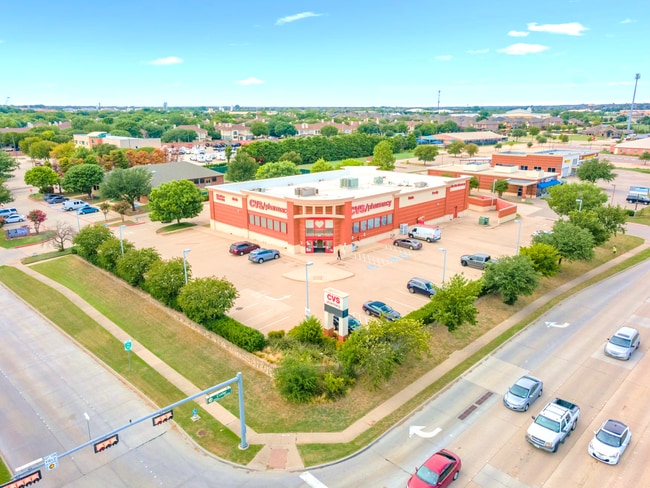
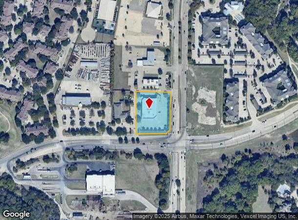
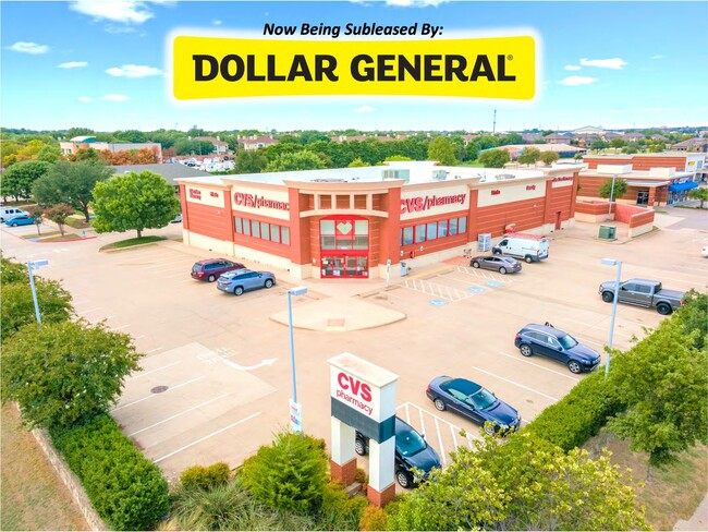
This Property Is For Sale
Property Detail
10001 Custer Rd
Dallas-Fort Worth-Arlington, TX
Custer-Ridgeview Addition (Cpl)
R-8129-001-0050-1
CUSTER-RIDGEVIEW ADDITION, BLK 1, LOT 5
Commercialnec
Collin
X
Texas
48085C0380K
5
2024
1.47 AC
2025
Central Plano
031665
Dallas/Ft Worth
12,419 SF
NEARBY LISTINGS FOR SALE OR LEASE
DEMOGRAPHICS near 10001 Custer Rd
1 mile
3 mile
5 mile
2024 Total Population
14,706
137,041
379,591
2029 Population
17,879
167,518
463,886
Pop Growth 2024-2029
+ 21.58%
+ 22.24%
+ 22.21%
Average Age
36
37
37
2024 Total Households
5,098
46,803
135,599
HH Growth 2024-2029
+ 21.83%
+ 22.51%
+ 22.50%
Median Household Inc
$108,736
$138,931
$116,835
Avg Household Size
2.80
2.90
2.80
2024 Avg HH Vehicles
2.00
2.00
2.00
Median Home Value
$494,948
$463,721
$423,507
Median Year Built
2003
2003
2002
Nearby Places
Map Layers
Map Styles
 Street
 Aerial
Transit
 Traffic
 Biking
Places
Listings with unknown addresses are not visible on the map
- Restaurants
- Banks
- Shops
- Fitness
- Groceries
PUBLIC TRANSPORTATION
AIRPORT
Dallas Love Field
Drive
Walk
Distance
Dallas Love Field
37 min
26.9 mi
Dallas-Fort Worth International
Drive
Walk
Distance
Dallas-Fort Worth International
34 min
27.7 mi
Freight Ports
Port of Shreveport
Drive
Walk
Distance
Port of Shreveport
237 min
216.6 mi
Nearby Properties
Address
Land Use
TOTAL SIZE
Lot Size
Zoning
Address
Land Use
TOTAL SIZE
Lot Size
Zoning
766,124 SF
62.04 AC
Address
Land Use
TOTAL SIZE
Lot Size
Zoning
649,703 SF
31.92 AC
MF
Address
Land Use
TOTAL SIZE
Lot Size
Zoning
535,339 SF
54.76 AC
Address
Land Use
TOTAL SIZE
Lot Size
Zoning
387,377 SF
64.34 AC
Address
Land Use
TOTAL SIZE
Lot Size
Zoning
511,762 SF
28.81 AC
Address
Land Use
TOTAL SIZE
Lot Size
Zoning
557,288 SF
9.18 AC
Address
Land Use
TOTAL SIZE
Lot Size
Zoning
419,994 SF
19.83 AC
MF-M
Address
Land Use
TOTAL SIZE
Lot Size
Zoning
584,548 SF
33.76 AC
MF
Address
Land Use
TOTAL SIZE
Lot Size
Zoning
493,621 SF
17 AC
APTS
Address
Land Use
TOTAL SIZE
Lot Size
Zoning
537,872 SF
36.28 AC
MF
Address
Land Use
TOTAL SIZE
Lot Size
Zoning
435,382 SF
6.95 AC
MF-E
Address
Land Use
TOTAL SIZE
Lot Size
Zoning
393,074 SF
24.03 AC
MFM
Address
Land Use
TOTAL SIZE
Lot Size
Zoning
294,229 SF
32.11 AC
Address
Land Use
TOTAL SIZE
Lot Size
Zoning
556,741 SF
8.70 AC
MF-R
Address
Land Use
TOTAL SIZE
Lot Size
Zoning
346,285 SF
5.05 AC
Address
Land Use
TOTAL SIZE
Lot Size
Zoning
369,702 SF
5.10 AC
Address
Land Use
TOTAL SIZE
Lot Size
Zoning
442,695 SF
24.65 AC
MF-M
Address
Land Use
TOTAL SIZE
Lot Size
Zoning
483,386 SF
4.62 AC
MF-R
Address
Land Use
TOTAL SIZE
Lot Size
Zoning
464,454 SF
11.04 AC
PD
Address
Land Use
TOTAL SIZE
Lot Size
Zoning
471,114 SF
26.05 AC
MF-M
Address
Land Use
TOTAL SIZE
Lot Size
Zoning
397,395 SF
12.25 AC
Address
Land Use
TOTAL SIZE
Lot Size
Zoning
508,028 SF
14.61 AC
Address
Land Use
TOTAL SIZE
Lot Size
Zoning
199,115 SF
1.36 AC
Address
Land Use
TOTAL SIZE
Lot Size
Zoning
357,097 SF
19.68 AC
MF-M
Address
Land Use
TOTAL SIZE
Lot Size
Zoning
390,948 SF
21.95 AC
MF-M
Address
Land Use
TOTAL SIZE
Lot Size
Zoning
334,313 SF
13.61 AC
MF
Address
Land Use
TOTAL SIZE
Lot Size
Zoning
337,425 SF
7.44 AC
MF-E
Address
Land Use
TOTAL SIZE
Lot Size
Zoning
442,463 SF
17.34 AC
Address
Land Use
TOTAL SIZE
Lot Size
Zoning
439,754 SF
13.09 AC
SF
Address
Land Use
TOTAL SIZE
Lot Size
Zoning
443,704 SF
18.87 AC
MFM
The World's #1 Commercial Real Estate Marketplace
Connect with us
© 2026 CoStar Group
The information above has been obtained from sources believed reliable. While we do not doubt its accuracy we have not verified it and make no guarantee, warranty or representation about it. It is your responsibility to independently confirm its accuracy and completeness. Any projections, opinions, assumptions, or estimates used are for example only and do not represent the current or future performance of the property. The value of this transaction to you depends on tax and other factors which should be evaluated by your tax, financial, and legal advisors. You and your advisors should conduct a careful, independent investigation of the property to determine to your satisfaction the suitability of the property for your needs.