Property Record
1001 Cliff Rd E, Burnsville, MN 55337


Save to a Folder
{{folder.Name}}
{{folder.ListingIds.length}} Properties
{{folder.ListingIds.length}} Property
Create a New Folder
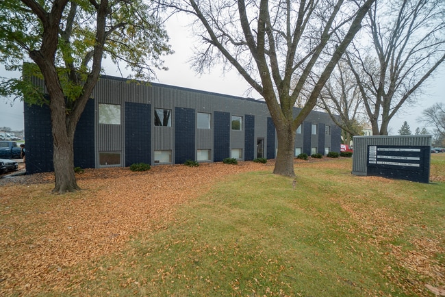
Property Detail
1001 Cliff Rd E
Minneapolis-St. Paul-Bloomington, MN-WI
RIVERWOOD INDUSTRIAL PARK PLAT 4 1 1
02-64303-01-010
Dakota
Industrialgeneral
Minnesota
B and X Area of moderate flood hazard, usually the area between the limits of the 100-year and 500-year floods.
10
2025
1.23 AC
2025
South Central
060748
Minneapolis/St Paul
19,742 SF
NEARBY LISTINGS FOR SALE OR LEASE
DEMOGRAPHICS near 1001 Cliff Rd E
1 mile
3 mile
5 mile
2025 Total Population
6,887
70,476
199,808
2030 Population
6,975
71,793
202,926
Pop Growth 2025-2030
+ 1.28%
+ 1.87%
+ 1.56%
Average Age
39
40
41
2025 Total Households
3,047
28,604
79,707
HH Growth 2025-2030
+ 1.51%
+ 2.01%
+ 1.71%
Median Household Inc
$65,764
$82,715
$88,575
Avg Household Size
2.20
2.40
2.40
2025 Avg HH Vehicles
2.00
2.00
2.00
Median Home Value
$307,733
$349,660
$358,972
Median Year Built
1982
1978
1979
Nearby Places
Map Layers
Map Styles
 Street
 Aerial
Layers
 Traffic
 Biking
Places
Listings with unknown addresses are not visible on the map
- Restaurants
- Banks
- Shops
- Fitness
- Groceries
PUBLIC TRANSPORTATION
AIRPORT
Minneapolis-St Paul International/Wold-Chamberlain
Drive
Walk
Distance
Minneapolis-St Paul International/Wold-Chamberlain
17 min
9.2 mi
SALE & LEASE HISTORY
LISTING DATE
SALE/LEASE

Sep 26, 2025
For Lease
Mar 17, 2018
For Lease
Jul 02, 2019
For Lease
Jan 25, 2017
For Lease
Dec 03, 2024
For Sale
Apr 26, 2023
For Lease
Nearby Properties
Address
Land Use
TOTAL SIZE
Lot Size
Zoning
Address
Land Use
TOTAL SIZE
Lot Size
Zoning
1,341.19 AC
Address
Land Use
TOTAL SIZE
Lot Size
Zoning
752,064 SF
24.03 AC
Address
Land Use
TOTAL SIZE
Lot Size
Zoning
129,658 SF
13.52 AC
Address
Land Use
TOTAL SIZE
Lot Size
Zoning
122,021 SF
21.74 AC
Address
Land Use
TOTAL SIZE
Lot Size
Zoning
584,692 SF
15.70 AC
Address
Land Use
TOTAL SIZE
Lot Size
Zoning
230,883 SF
2.49 AC
Address
Land Use
TOTAL SIZE
Lot Size
Zoning
282,095 SF
2.71 AC
Address
Land Use
TOTAL SIZE
Lot Size
Zoning
142,229 SF
26.61 AC
Address
Land Use
TOTAL SIZE
Lot Size
Zoning
24,750 SF
14.36 AC
Address
Land Use
TOTAL SIZE
Lot Size
Zoning
299,435 SF
7.65 AC
Address
Land Use
TOTAL SIZE
Lot Size
Zoning
419,750 SF
13.83 AC
Address
Land Use
TOTAL SIZE
Lot Size
Zoning
374,415 SF
20.10 AC
Address
Land Use
TOTAL SIZE
Lot Size
Zoning
394,700 SF
13.23 AC
Address
Land Use
TOTAL SIZE
Lot Size
Zoning
289,168 SF
11.73 AC
Address
Land Use
TOTAL SIZE
Lot Size
Zoning
265,406 SF
26.78 AC
Address
Land Use
TOTAL SIZE
Lot Size
Zoning
177,489 SF
1.75 AC
Address
Land Use
TOTAL SIZE
Lot Size
Zoning
273,843 SF
17.55 AC
Address
Land Use
TOTAL SIZE
Lot Size
Zoning
216,267 SF
3.69 AC
Address
Land Use
TOTAL SIZE
Lot Size
Zoning
174,245 SF
2.90 AC
Address
Land Use
TOTAL SIZE
Lot Size
Zoning
287,255 SF
14.69 AC
Address
Land Use
TOTAL SIZE
Lot Size
Zoning
234,348 SF
11.21 AC
Address
Land Use
TOTAL SIZE
Lot Size
Zoning
260,290 SF
13.28 AC
Address
Land Use
TOTAL SIZE
Lot Size
Zoning
256,907 SF
7.43 AC
Address
Land Use
TOTAL SIZE
Lot Size
Zoning
112.48 AC
Address
Land Use
TOTAL SIZE
Lot Size
Zoning
231,928 SF
16.63 AC
Address
Land Use
TOTAL SIZE
Lot Size
Zoning
421,893 SF
21.17 AC
Address
Land Use
TOTAL SIZE
Lot Size
Zoning
419,750 SF
10.86 AC
Address
Land Use
TOTAL SIZE
Lot Size
Zoning
62,165 SF
13.21 AC
Address
Land Use
TOTAL SIZE
Lot Size
Zoning
158,620 SF
1.80 AC
Address
Land Use
TOTAL SIZE
Lot Size
Zoning
179,288 SF
12.88 AC
The World's #1 Commercial Real Estate Marketplace
Connect with us
© 2026 CoStar Group
The information above has been obtained from sources believed reliable. While we do not doubt its accuracy we have not verified it and make no guarantee, warranty or representation about it. It is your responsibility to independently confirm its accuracy and completeness. Any projections, opinions, assumptions, or estimates used are for example only and do not represent the current or future performance of the property. The value of this transaction to you depends on tax and other factors which should be evaluated by your tax, financial, and legal advisors. You and your advisors should conduct a careful, independent investigation of the property to determine to your satisfaction the suitability of the property for your needs.