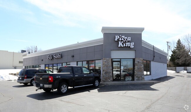
Property Record
1003 W Northland Ave, Appleton, WI 54914


Current Lease Availabilities
NEARBY LISTINGS FOR SALE OR LEASE
Property Detail
1003 W Northland Ave
31-5-9529-32
SEC22 T21N R17E E122.6FT OF BEG AT PT IN S/L CTH 00 1250FT EAST OF N&S1/4 SEC/L S196FT W122.6FT N196FT E222.6FT TO BEG PRT NW1/4 OF NE 0.55AC
Commercialnec
Outagamie
X
Wisconsin
55087C0316D
0.55 AC
2023
Outagamie County
2023
Green Bay
011101
Appleton, WI
5,600 SF
DEMOGRAPHICS near 1003 W Northland Ave
1 mile
3 mile
5 mile
2024 Total Population
13,302
74,071
146,428
2029 Population
13,736
76,990
151,153
Pop Growth 2024-2029
+ 3.26%
+ 3.94%
+ 3.23%
Average Age
41
40
40
2024 Total Households
5,759
30,891
60,833
HH Growth 2024-2029
+ 3.11%
+ 3.95%
+ 3.21%
Median Household Inc
$65,995
$68,992
$69,834
Avg Household Size
2.20
2.30
2.30
2024 Avg HH Vehicles
2.00
2.00
2.00
Median Home Value
$180,735
$192,096
$202,608
Median Year Built
1971
1972
1979
Nearby Places
Map Layers
Map Styles
 Street
 Aerial
Transit
 Traffic
 Biking
Places
Listings with unknown addresses are not visible on the map
- Restaurants
- Banks
- Shops
- Fitness
- Groceries
PUBLIC TRANSPORTATION
AIRPORT
Appleton International
Drive
Walk
Distance
Appleton International
16 min
9.1 mi
Green Bay/Austin Straubel International
Drive
Walk
Distance
Green Bay/Austin Straubel International
35 min
26.6 mi
Nearby Properties
Address
Land Use
TOTAL SIZE
Lot Size
Zoning
Address
Land Use
TOTAL SIZE
Lot Size
Zoning
645,392 SF
25.87 AC
Address
Land Use
TOTAL SIZE
Lot Size
Zoning
154,889 SF
1 AC
C2
Address
Land Use
TOTAL SIZE
Lot Size
Zoning
500,700 SF
47.17 AC
Address
Land Use
TOTAL SIZE
Lot Size
Zoning
189,107 SF
13.37 AC
Address
Land Use
TOTAL SIZE
Lot Size
Zoning
3.42 AC
PDC2
Address
Land Use
TOTAL SIZE
Lot Size
Zoning
84,620 SF
92.18 AC
C2
Address
Land Use
TOTAL SIZE
Lot Size
Zoning
70,136 SF
6.34 AC
C2
Address
Land Use
TOTAL SIZE
Lot Size
Zoning
2,032 SF
18.48 AC
R3
Address
Land Use
TOTAL SIZE
Lot Size
Zoning
65,818 SF
8.01 AC
C2
Address
Land Use
TOTAL SIZE
Lot Size
Zoning
6.59 AC
M1
Address
Land Use
TOTAL SIZE
Lot Size
Zoning
29,742 SF
5.95 AC
R3
Address
Land Use
TOTAL SIZE
Lot Size
Zoning
278,801 SF
20.94 AC
Address
Land Use
TOTAL SIZE
Lot Size
Zoning
194,573 SF
19.99 AC
Address
Land Use
TOTAL SIZE
Lot Size
Zoning
53,321 SF
2.51 AC
CBD
Address
Land Use
TOTAL SIZE
Lot Size
Zoning
44,164 SF
0.62 AC
CBD
Address
Land Use
TOTAL SIZE
Lot Size
Zoning
17.43 AC
M2
Address
Land Use
TOTAL SIZE
Lot Size
Zoning
40,560 SF
6.67 AC
R3
Address
Land Use
TOTAL SIZE
Lot Size
Zoning
107,202 SF
39.98 AC
C2
Address
Land Use
TOTAL SIZE
Lot Size
Zoning
66,504 SF
5.25 AC
C2
Address
Land Use
TOTAL SIZE
Lot Size
Zoning
15,560 SF
15.24 AC
Address
Land Use
TOTAL SIZE
Lot Size
Zoning
6.66 AC
Address
Land Use
TOTAL SIZE
Lot Size
Zoning
249,444 SF
18.81 AC
Address
Land Use
TOTAL SIZE
Lot Size
Zoning
13,994 SF
8.13 AC
R3
Address
Land Use
TOTAL SIZE
Lot Size
Zoning
5,394 SF
0.30 AC
CBD
Address
Land Use
TOTAL SIZE
Lot Size
Zoning
62,673 SF
3.19 AC
PDC2
Address
Land Use
TOTAL SIZE
Lot Size
Zoning
21,540 SF
0.79 AC
CBD
Address
Land Use
TOTAL SIZE
Lot Size
Zoning
25,705 SF
2.03 AC
PDR3
Address
Land Use
TOTAL SIZE
Lot Size
Zoning
83,926 SF
7.35 AC
C2
Address
Land Use
TOTAL SIZE
Lot Size
Zoning
45,646 SF
44 SF
PDC2
Address
Land Use
TOTAL SIZE
Lot Size
Zoning
83,673 SF
1.48 AC
PDC2
The World's #1 Commercial Real Estate Marketplace
Connect with us
© 2026 CoStar Group
The information above has been obtained from sources believed reliable. While we do not doubt its accuracy we have not verified it and make no guarantee, warranty or representation about it. It is your responsibility to independently confirm its accuracy and completeness. Any projections, opinions, assumptions, or estimates used are for example only and do not represent the current or future performance of the property. The value of this transaction to you depends on tax and other factors which should be evaluated by your tax, financial, and legal advisors. You and your advisors should conduct a careful, independent investigation of the property to determine to your satisfaction the suitability of the property for your needs.