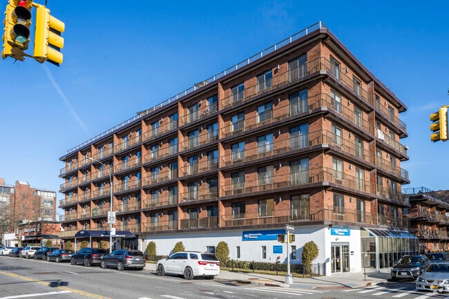
Property Record
10031 4Th Ave, Brooklyn, NY 11209

NEARBY LISTINGS FOR SALE OR LEASE
Property Detail
10031 4Th Ave
06138-0001
DOCID-2019021100596001ADDL BLK-LOT: 6138-6,9001
Funeralhome
Kings
X
New York
3604970331F
1
2024
0.10 AC
2025
Bay Ridge
016200
Long Island (New York)
9,000 SF
New York-Jersey City-White Plains, NY-NJ
DEMOGRAPHICS near 10031 4Th Ave
1 Mile
3 Mile
5 Mile
2024 Total Population
39,744
510,971
1,263,776
2029 Population
37,435
472,479
1,189,286
Pop Growth 2024-2029
(5.81%)
(7.53%)
(5.89%)
Average Age
43
39
40
2024 Total Households
17,651
168,445
441,351
HH Growth 2024-2029
(6.24%)
(7.80%)
(6.13%)
Median Household Inc
$79,568
$62,258
$67,370
Avg Household Size
2.20
2.90
2.70
2024 Avg HH Vehicles
1.00
1.00
1.00
Median Home Value
$816,786
$828,179
$794,874
Median Year Built
1947
1947
1948
Nearby Places
Map Layers
Map Styles
 Street
 Aerial
- Restaurants
- Banks
- Shops
- Fitness
- Groceries
PUBLIC TRANSPORTATION
TRANSIT/SUBWAY
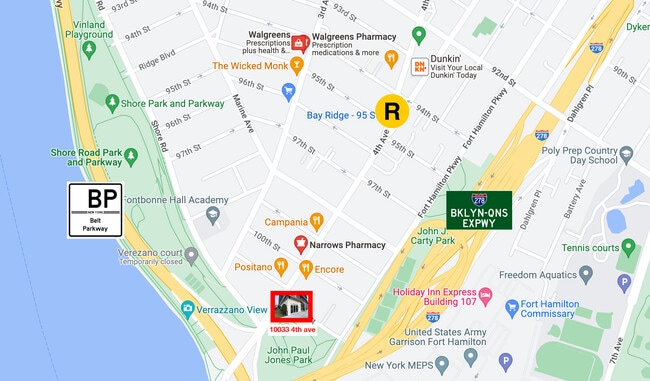
Bay Ridge-95 Street (R - New York MTA Subway (The Subway))
DRIVE
WALK
Distance
Bay Ridge-95 Street (R - New York MTA Subway (The Subway))
1 min
8 min
0.4 mi
86 Street (R Line) (R - New York MTA Subway (The Subway))
DRIVE
WALK
Distance
86 Street (R Line) (R - New York MTA Subway (The Subway))
2 min
17 min
0.9 mi
COMMUTER RAIL
Clifton (Staten Island Railway - New York MTA Subway (The Subway))
DRIVE
WALK
Distance
Clifton (Staten Island Railway - New York MTA Subway (The Subway))
10 min
5.0 mi
Stapleton (Staten Island Railway - New York MTA Subway (The Subway))
DRIVE
WALK
Distance
Stapleton (Staten Island Railway - New York MTA Subway (The Subway))
12 min
5.7 mi
AIRPORT
LaGuardia
DRIVE
WALK
Distance
LaGuardia
30 min
17.9 mi
John F Kennedy International
DRIVE
WALK
Distance
John F Kennedy International
27 min
19.6 mi
Newark Liberty International
DRIVE
WALK
Distance
Newark Liberty International
31 min
19.7 mi
Freight Ports
GCT Bayonne
DRIVE
WALK
Distance
GCT Bayonne
28 min
15.5 mi
SALE & LEASE HISTORY
LISTING DATE
SALE/LEASE

Jan 25, 2023
For Lease
Nearby Properties
Address
Land Use
TOTAL SIZE
Lot Size
Zoning
Address
Land Use
TOTAL SIZE
Lot Size
Zoning
1,524,659 SF
170.96 AC
R4
Address
Land Use
TOTAL SIZE
Lot Size
Zoning
965,600 SF
6.65 AC
R5
Address
Land Use
TOTAL SIZE
Lot Size
Zoning
460,000 SF
3.21 AC
R6
Address
Land Use
TOTAL SIZE
Lot Size
Zoning
335,800 SF
1.51 AC
R6
Address
Land Use
TOTAL SIZE
Lot Size
Zoning
397,354 SF
0.61 AC
C5-2
Address
Land Use
TOTAL SIZE
Lot Size
Zoning
135,000 SF
117.71 AC
PARK
Address
Land Use
TOTAL SIZE
Lot Size
Zoning
236,591 SF
207.66 AC
R3-2
Address
Land Use
TOTAL SIZE
Lot Size
Zoning
5,359,400 SF
59.07 AC
M2-1
Address
Land Use
TOTAL SIZE
Lot Size
Zoning
286,000 SF
12.63 AC
PARK
Address
Land Use
TOTAL SIZE
Lot Size
Zoning
301,400 SF
22.27 AC
M3-1
Address
Land Use
TOTAL SIZE
Lot Size
Zoning
139,557 SF
11.47 AC
M1-1
Address
Land Use
TOTAL SIZE
Lot Size
Zoning
171,591 SF
0.14 AC
C5-2
Address
Land Use
TOTAL SIZE
Lot Size
Zoning
183,215 SF
3.47 AC
C4-2
Address
Land Use
TOTAL SIZE
Lot Size
Zoning
292,528 SF
1.05 AC
R6
Address
Land Use
TOTAL SIZE
Lot Size
Zoning
152,440 SF
23.07 AC
R4B
Address
Land Use
TOTAL SIZE
Lot Size
Zoning
43,068 SF
216.83 AC
PARK
Address
Land Use
TOTAL SIZE
Lot Size
Zoning
356,000 SF
8.19 AC
R5
Address
Land Use
TOTAL SIZE
Lot Size
Zoning
146,855 SF
16.50 AC
R3-1
Address
Land Use
TOTAL SIZE
Lot Size
Zoning
128,170 SF
0.87 AC
R7A
Address
Land Use
TOTAL SIZE
Lot Size
Zoning
16,570 SF
240.82 AC
PARK
Address
Land Use
TOTAL SIZE
Lot Size
Zoning
414,400 SF
2.70 AC
R7A
Address
Land Use
TOTAL SIZE
Lot Size
Zoning
105,328 SF
0.11 AC
M1-6
Address
Land Use
TOTAL SIZE
Lot Size
Zoning
149,000 SF
17.68 AC
M1-1
Address
Land Use
TOTAL SIZE
Lot Size
Zoning
219,973 SF
0.39 AC
R8
Address
Land Use
TOTAL SIZE
Lot Size
Zoning
131,650 SF
0.83 AC
R6
Address
Land Use
TOTAL SIZE
Lot Size
Zoning
148,410 SF
0.67 AC
R6
Address
Land Use
TOTAL SIZE
Lot Size
Zoning
654,030 SF
13.94 AC
R5
Address
Land Use
TOTAL SIZE
Lot Size
Zoning
330,780 SF
676.51 AC
C4-2A
Address
Land Use
TOTAL SIZE
Lot Size
Zoning
98,849 SF
0.83 AC
R7B
Address
Land Use
TOTAL SIZE
Lot Size
Zoning
222,265 SF
0.74 AC
R6
The World's #1 Commercial Real Estate Marketplace
Connect with us
© 2026 CoStar Group
The information above has been obtained from sources believed reliable. While we do not doubt its accuracy we have not verified it and make no guarantee, warranty or representation about it. It is your responsibility to independently confirm its accuracy and completeness. Any projections, opinions, assumptions, or estimates used are for example only and do not represent the current or future performance of the property. The value of this transaction to you depends on tax and other factors which should be evaluated by your tax, financial, and legal advisors. You and your advisors should conduct a careful, independent investigation of the property to determine to your satisfaction the suitability of the property for your needs.