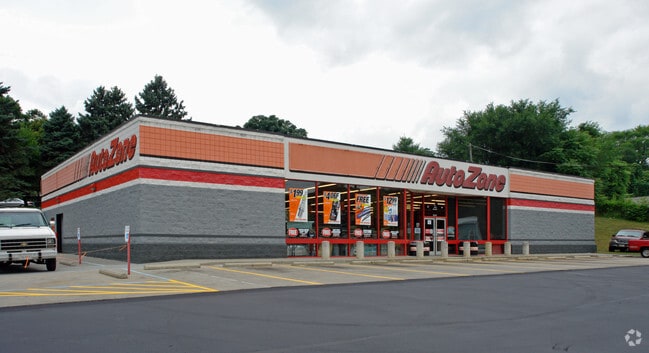
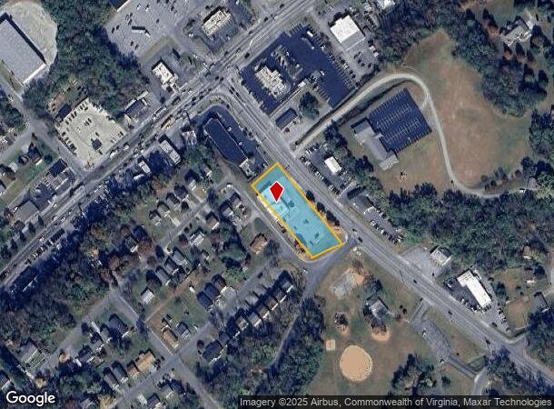
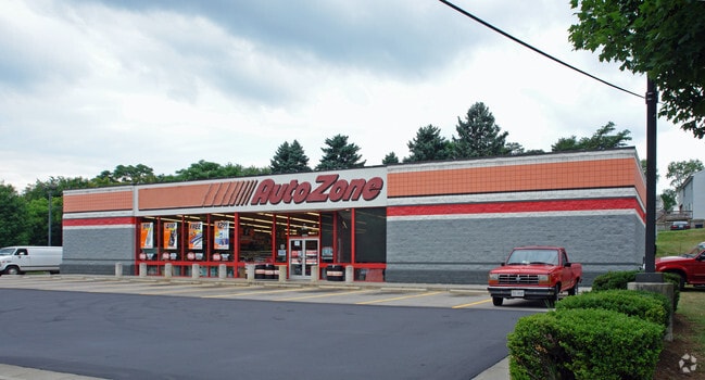
Property Record
1004 Gus W Nicks Blvd Ne, Roanoke, VA 24012
NEARBY LISTINGS FOR SALE OR LEASE
Property Detail
1004 Gus W Nicks Blvd Ne
3330412
ACREAGE KENWOOD
Multipleuses
Roanoke City
X
Virginia
51161C0166G
0.89 AC
2025
Southeast Roanoke
2025
Roanoke
000602
Roanoke, VA
6,487 SF
DEMOGRAPHICS near 1004 Gus W Nicks Blvd Ne
1 Mile
3 Mile
5 Mile
2024 Total Population
6,453
59,694
119,325
2029 Population
6,438
58,849
117,824
Pop Growth 2024-2029
(0.23%)
(1.42%)
(1.26%)
Average Age
37
40
41
2024 Total Households
2,881
25,907
51,646
HH Growth 2024-2029
(0.17%)
(1.41%)
(1.31%)
Median Household Inc
$45,761
$48,952
$52,519
Avg Household Size
2.20
2.20
2.20
2024 Avg HH Vehicles
2.00
2.00
2.00
Median Home Value
$139,117
$161,927
$183,135
Median Year Built
1973
1964
1965
Nearby Places
Map Layers
Map Styles
 Street
 Aerial
- Restaurants
- Banks
- Shops
- Fitness
- Groceries
PUBLIC TRANSPORTATION
COMMUTER RAIL
DRIVE
WALK
Distance
7 min
2.8 mi
AIRPORT
Roanoke/Blacksburg Regional (Woodrum Field)
DRIVE
WALK
Distance
Roanoke/Blacksburg Regional (Woodrum Field)
13 min
5.9 mi
Nearby Properties
Address
Land Use
TOTAL SIZE
Lot Size
Zoning
Address
Land Use
TOTAL SIZE
Lot Size
Zoning
370 SF
105.25 AC
I-2
Address
Land Use
TOTAL SIZE
Lot Size
Zoning
476,613 SF
5.29 AC
D
Address
Land Use
TOTAL SIZE
Lot Size
Zoning
214,543 SF
38.29 AC
R1S
Address
Land Use
TOTAL SIZE
Lot Size
Zoning
96,620 SF
26.84 AC
D
Address
Land Use
TOTAL SIZE
Lot Size
Zoning
217,815 SF
3.02 AC
INPUD
Address
Land Use
TOTAL SIZE
Lot Size
Zoning
87,406 SF
1.15 AC
D
Address
Land Use
TOTAL SIZE
Lot Size
Zoning
211,622 SF
2.18 AC
INPUD
Address
Land Use
TOTAL SIZE
Lot Size
Zoning
3,404 SF
17.41 AC
MXPUD
Address
Land Use
TOTAL SIZE
Lot Size
Zoning
1.51 AC
INPUD
Address
Land Use
TOTAL SIZE
Lot Size
Zoning
262,715 SF
5.09 AC
D
Address
Land Use
TOTAL SIZE
Lot Size
Zoning
71,696 SF
71.64 AC
INPUD/ROS
Address
Land Use
TOTAL SIZE
Lot Size
Zoning
1.25 AC
D
Address
Land Use
TOTAL SIZE
Lot Size
Zoning
504,343 SF
2.80 AC
INPUD
Address
Land Use
TOTAL SIZE
Lot Size
Zoning
81,500 SF
0.63 AC
D
Address
Land Use
TOTAL SIZE
Lot Size
Zoning
12,220 SF
5.09 AC
D
Address
Land Use
TOTAL SIZE
Lot Size
Zoning
150,151 SF
0.84 AC
D
Address
Land Use
TOTAL SIZE
Lot Size
Zoning
33,249 SF
5.50 AC
D
Address
Land Use
TOTAL SIZE
Lot Size
Zoning
141,056 SF
2.49 AC
D
Address
Land Use
TOTAL SIZE
Lot Size
Zoning
206,418 SF
1.50 AC
D
Address
Land Use
TOTAL SIZE
Lot Size
Zoning
67,486 SF
3.99 AC
RMF
Address
Land Use
TOTAL SIZE
Lot Size
Zoning
73,575 SF
2.52 AC
D
Address
Land Use
TOTAL SIZE
Lot Size
Zoning
122,814 SF
0.98 AC
INPUD
Address
Land Use
TOTAL SIZE
Lot Size
Zoning
238,125 SF
0.37 AC
D
Address
Land Use
TOTAL SIZE
Lot Size
Zoning
209,930 SF
1.49 AC
D
Address
Land Use
TOTAL SIZE
Lot Size
Zoning
160,537 SF
11.08 AC
I-1
Address
Land Use
TOTAL SIZE
Lot Size
Zoning
402,320 SF
42.13 AC
I1C
Address
Land Use
TOTAL SIZE
Lot Size
Zoning
387,684 SF
27.44 AC
I-1
Address
Land Use
TOTAL SIZE
Lot Size
Zoning
142,048 SF
21.38 AC
I-1
Address
Land Use
TOTAL SIZE
Lot Size
Zoning
92,235 SF
0.49 AC
D
Address
Land Use
TOTAL SIZE
Lot Size
Zoning
609,211 SF
41.01 AC
I1C
The World's #1 Commercial Real Estate Marketplace
Connect with us
© 2025 CoStar Group
The information above has been obtained from sources believed reliable. While we do not doubt its accuracy we have not verified it and make no guarantee, warranty or representation about it. It is your responsibility to independently confirm its accuracy and completeness. Any projections, opinions, assumptions, or estimates used are for example only and do not represent the current or future performance of the property. The value of this transaction to you depends on tax and other factors which should be evaluated by your tax, financial, and legal advisors. You and your advisors should conduct a careful, independent investigation of the property to determine to your satisfaction the suitability of the property for your needs.