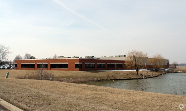
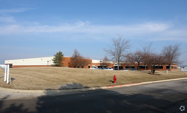
Property Record
101 Kendall Point Dr, Oswego, IL 60543

Property Detail
101 Kendall Point Dr
Chicago-Naperville-Elgin, IL-IN
LOT 1 KENDALL POINT BUSINESS CENTER UNIT 1 VILLAGE OF OSWEGO
03-02-351-001
Kendall
Commercialnec
Illinois
B and X Area of moderate flood hazard, usually the area between the limits of the 100-year and 500-year floods.
1
2024
6.79 AC
2025
I-88 West
890103
Chicago
73,755 SF
NEARBY LISTINGS FOR SALE OR LEASE
DEMOGRAPHICS near 101 Kendall Point Dr
1 mile
3 mile
5 mile
2025 Total Population
7,670
92,092
229,778
2030 Population
8,225
94,707
235,835
Pop Growth 2025-2030
+ 7.24%
+ 2.84%
+ 2.64%
Average Age
36
37
37
2025 Total Households
2,725
29,779
75,175
HH Growth 2025-2030
+ 7.01%
+ 2.96%
+ 2.68%
Median Household Inc
$92,210
$92,616
$99,782
Avg Household Size
2.80
3.00
3.00
2025 Avg HH Vehicles
2.00
2.00
2.00
Median Home Value
$283,333
$266,285
$290,499
Median Year Built
2002
1990
1990
Nearby Places
Map Layers
Map Styles
 Street
 Aerial
Layers
 Traffic
 Biking
Places
Listings with unknown addresses are not visible on the map
- Restaurants
- Banks
- Shops
- Fitness
- Groceries
PUBLIC TRANSPORTATION
COMMUTER RAIL
Aurora Station (Burlington Northern-Santa Fe Railway Line - Northeast Illinois Regional Commuter Railroad (Metra))
Drive
Walk
Distance
Aurora Station (Burlington Northern-Santa Fe Railway Line - Northeast Illinois Regional Commuter Railroad (Metra))
10 min
5.3 mi
Route 59 Station (Burlington Northern-Santa Fe Railway Line - Northeast Illinois Regional Commuter Railroad (Metra))
Drive
Walk
Distance
Route 59 Station (Burlington Northern-Santa Fe Railway Line - Northeast Illinois Regional Commuter Railroad (Metra))
16 min
8.3 mi
AIRPORT
Chicago Midway International
Drive
Walk
Distance
Chicago Midway International
53 min
31.8 mi
Chicago O'Hare International
Drive
Walk
Distance
Chicago O'Hare International
59 min
38.5 mi
Freight Ports
Port Milwaukee
Drive
Walk
Distance
Port Milwaukee
140 min
110.2 mi
SALE & LEASE HISTORY
LISTING DATE
SALE/LEASE

Jul 08, 2022
For Lease
Nearby Properties
Address
Land Use
TOTAL SIZE
Lot Size
Zoning
Address
Land Use
TOTAL SIZE
Lot Size
Zoning
272,948 SF
16.10 AC
Address
Land Use
TOTAL SIZE
Lot Size
Zoning
81,342 SF
16.73 AC
Address
Land Use
TOTAL SIZE
Lot Size
Zoning
20.76 AC
Address
Land Use
TOTAL SIZE
Lot Size
Zoning
121,608 SF
27.48 AC
Address
Land Use
TOTAL SIZE
Lot Size
Zoning
296,502 SF
19.01 AC
Address
Land Use
TOTAL SIZE
Lot Size
Zoning
173,303 SF
19.53 AC
Address
Land Use
TOTAL SIZE
Lot Size
Zoning
244,494 SF
16.08 AC
Address
Land Use
TOTAL SIZE
Lot Size
Zoning
233,437 SF
13.11 AC
Address
Land Use
TOTAL SIZE
Lot Size
Zoning
989,724 SF
49.41 AC
Address
Land Use
TOTAL SIZE
Lot Size
Zoning
8.87 AC
Address
Land Use
TOTAL SIZE
Lot Size
Zoning
220,091 SF
22.09 AC
Address
Land Use
TOTAL SIZE
Lot Size
Zoning
207,596 SF
20.63 AC
Address
Land Use
TOTAL SIZE
Lot Size
Zoning
156,614 SF
17.63 AC
Address
Land Use
TOTAL SIZE
Lot Size
Zoning
366,503 SF
11.88 AC
Address
Land Use
TOTAL SIZE
Lot Size
Zoning
140,888 SF
16.31 AC
Address
Land Use
TOTAL SIZE
Lot Size
Zoning
85,440 SF
0.58 AC
Address
Land Use
TOTAL SIZE
Lot Size
Zoning
51,375 SF
8.73 AC
Address
Land Use
TOTAL SIZE
Lot Size
Zoning
82,150 SF
23.67 AC
Address
Land Use
TOTAL SIZE
Lot Size
Zoning
217,505 SF
17.50 AC
Address
Land Use
TOTAL SIZE
Lot Size
Zoning
0.46 AC
Address
Land Use
TOTAL SIZE
Lot Size
Zoning
201,713 SF
16.55 AC
Address
Land Use
TOTAL SIZE
Lot Size
Zoning
2.58 AC
Address
Land Use
TOTAL SIZE
Lot Size
Zoning
34,560 SF
4.82 AC
Address
Land Use
TOTAL SIZE
Lot Size
Zoning
87,746 SF
8.01 AC
Address
Land Use
TOTAL SIZE
Lot Size
Zoning
136,919 SF
11.58 AC
Address
Land Use
TOTAL SIZE
Lot Size
Zoning
91,764 SF
5.86 AC
Address
Land Use
TOTAL SIZE
Lot Size
Zoning
146,500 SF
8.65 AC
Address
Land Use
TOTAL SIZE
Lot Size
Zoning
Address
Land Use
TOTAL SIZE
Lot Size
Zoning
133,611 SF
19.88 AC
Address
Land Use
TOTAL SIZE
Lot Size
Zoning
120,750 SF
11.07 AC
The World's #1 Commercial Real Estate Marketplace
Connect with us
© 2026 CoStar Group
The information above has been obtained from sources believed reliable. While we do not doubt its accuracy we have not verified it and make no guarantee, warranty or representation about it. It is your responsibility to independently confirm its accuracy and completeness. Any projections, opinions, assumptions, or estimates used are for example only and do not represent the current or future performance of the property. The value of this transaction to you depends on tax and other factors which should be evaluated by your tax, financial, and legal advisors. You and your advisors should conduct a careful, independent investigation of the property to determine to your satisfaction the suitability of the property for your needs.