Property Record
101 N Range Line Rd, Joplin, MO 64801
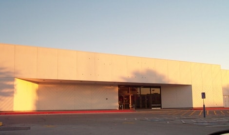


Property Detail
101 N Range Line Rd
20-3.0-06-00-000-001.002
JOP MISC BEG 166.59 N & 35 W NW COR NE SW E 660.58 S 560.15 W 165 S 165 W 212.11 N 45 DEG W 403.27 N 439.36 TO POB
Apartment
Jasper
B and X Area of moderate flood hazard, usually the area between the limits of the 100-year and 500-year floods.
Missouri
2024
8.53 AC
2025
Missouri South Area
010400
Other Market Areas
81,984 SF
Joplin, MO-KS
NEARBY LISTINGS FOR SALE OR LEASE
DEMOGRAPHICS near 101 N Range Line Rd
1 mile
3 mile
5 mile
2025 Total Population
4,914
41,562
78,182
2030 Population
5,006
42,786
80,742
Pop Growth 2025-2030
+ 1.87%
+ 2.94%
+ 3.27%
Average Age
39
38
39
2025 Total Households
2,173
17,528
32,399
HH Growth 2025-2030
+ 2.02%
+ 3.08%
+ 3.42%
Median Household Inc
$47,620
$46,761
$51,728
Avg Household Size
2.00
2.20
2.30
2025 Avg HH Vehicles
2.00
2.00
2.00
Median Home Value
$169,201
$171,498
$171,791
Median Year Built
1986
1985
1984
Nearby Places
Map Layers
Map Styles
 Street
 Aerial
Layers
 Traffic
 Biking
Places
Listings with unknown addresses are not visible on the map
- Restaurants
- Banks
- Shops
- Fitness
- Groceries
Nearby Properties
Address
Land Use
TOTAL SIZE
Lot Size
Zoning
Address
Land Use
TOTAL SIZE
Lot Size
Zoning
605,856 SF
40.96 AC
Address
Land Use
TOTAL SIZE
Lot Size
Zoning
380,504 SF
20.32 AC
Address
Land Use
TOTAL SIZE
Lot Size
Zoning
53,999 SF
18.47 AC
Address
Land Use
TOTAL SIZE
Lot Size
Zoning
195,092 SF
24.50 AC
Address
Land Use
TOTAL SIZE
Lot Size
Zoning
236,532 SF
205.82 AC
Address
Land Use
TOTAL SIZE
Lot Size
Zoning
28,488 SF
2.34 AC
Address
Land Use
TOTAL SIZE
Lot Size
Zoning
392,220 SF
29.78 AC
Address
Land Use
TOTAL SIZE
Lot Size
Zoning
531,297 SF
24.88 AC
Address
Land Use
TOTAL SIZE
Lot Size
Zoning
37,492 SF
11.54 AC
Address
Land Use
TOTAL SIZE
Lot Size
Zoning
220,377 SF
10.45 AC
Address
Land Use
TOTAL SIZE
Lot Size
Zoning
20,619 SF
4.56 AC
Address
Land Use
TOTAL SIZE
Lot Size
Zoning
62,916 SF
0.28 AC
Address
Land Use
TOTAL SIZE
Lot Size
Zoning
118,696 SF
19.09 AC
Address
Land Use
TOTAL SIZE
Lot Size
Zoning
194,326 SF
24.61 AC
Address
Land Use
TOTAL SIZE
Lot Size
Zoning
66,470 SF
7.71 AC
Address
Land Use
TOTAL SIZE
Lot Size
Zoning
76,512 SF
5.60 AC
Address
Land Use
TOTAL SIZE
Lot Size
Zoning
18,902 SF
4.02 AC
Address
Land Use
TOTAL SIZE
Lot Size
Zoning
85,574 SF
16.39 AC
Address
Land Use
TOTAL SIZE
Lot Size
Zoning
Address
Land Use
TOTAL SIZE
Lot Size
Zoning
11,550 SF
1.38 AC
Address
Land Use
TOTAL SIZE
Lot Size
Zoning
151,868 SF
16.74 AC
Address
Land Use
TOTAL SIZE
Lot Size
Zoning
142,801 SF
11.85 AC
Address
Land Use
TOTAL SIZE
Lot Size
Zoning
88,710 SF
8.75 AC
Address
Land Use
TOTAL SIZE
Lot Size
Zoning
124,230 SF
15.25 AC
Address
Land Use
TOTAL SIZE
Lot Size
Zoning
36,405 SF
4.04 AC
Address
Land Use
TOTAL SIZE
Lot Size
Zoning
41,287 SF
5.32 AC
Address
Land Use
TOTAL SIZE
Lot Size
Zoning
73,052 SF
0.62 AC
Address
Land Use
TOTAL SIZE
Lot Size
Zoning
12,211 SF
2.57 AC
Address
Land Use
TOTAL SIZE
Lot Size
Zoning
18,610 SF
1.66 AC
The World's #1 Commercial Real Estate Marketplace
Connect with us
© 2026 CoStar Group
The information above has been obtained from sources believed reliable. While we do not doubt its accuracy we have not verified it and make no guarantee, warranty or representation about it. It is your responsibility to independently confirm its accuracy and completeness. Any projections, opinions, assumptions, or estimates used are for example only and do not represent the current or future performance of the property. The value of this transaction to you depends on tax and other factors which should be evaluated by your tax, financial, and legal advisors. You and your advisors should conduct a careful, independent investigation of the property to determine to your satisfaction the suitability of the property for your needs.