Property Record
101 Old Grove Rd, Oceanside, CA 92057


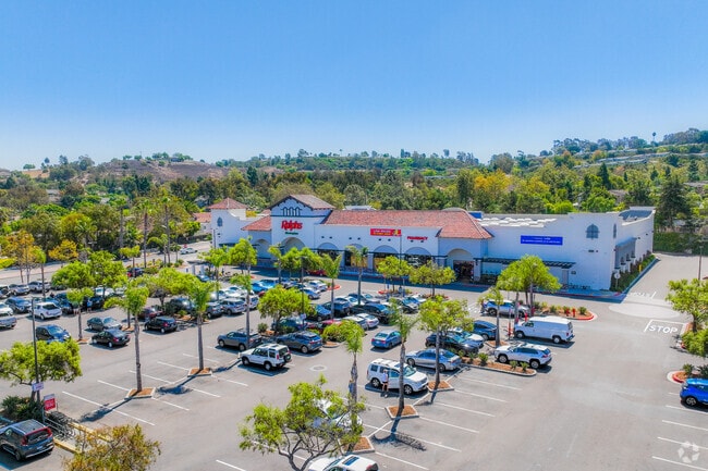

Property Detail
101 Old Grove Rd
158-101-50
PAR 4 ST CLSD & TR PM19200
Supermarket
San Diego
CS-HO-H
California
B and X Area of moderate flood hazard, usually the area between the limits of the 100-year and 500-year floods.
4.58 AC
2024
Oceanside
2025
San Diego
018521
San Diego-Chula Vista-Carlsbad, CA
52,598 SF
NEARBY LISTINGS FOR SALE OR LEASE
DEMOGRAPHICS near 101 Old Grove Rd
1 mile
3 mile
5 mile
2025 Total Population
19,750
117,649
276,214
2030 Population
19,732
117,864
277,457
Pop Growth 2025-2030
(0.09%)
+ 0.18%
+ 0.45%
Average Age
39
40
39
2025 Total Households
6,780
39,815
91,634
HH Growth 2025-2030
(0.21%)
+ 0.14%
+ 0.40%
Median Household Inc
$105,308
$100,884
$96,988
Avg Household Size
2.80
2.80
2.80
2025 Avg HH Vehicles
2.00
2.00
2.00
Median Home Value
$706,025
$721,649
$758,988
Median Year Built
1991
1985
1983
Nearby Places
Map Layers
Map Styles
 Street
 Aerial
Layers
 Traffic
 Biking
Places
Listings with unknown addresses are not visible on the map
- Restaurants
- Banks
- Shops
- Fitness
- Groceries
PUBLIC TRANSPORTATION
COMMUTER RAIL
Oceanside Transit Center (Orange County Line - Southern California Regional Rail Authority (Metrolink))
Drive
Walk
Distance
Oceanside Transit Center (Orange County Line - Southern California Regional Rail Authority (Metrolink))
12 min
6.7 mi
Carlsbad Village (Coaster - San Diego North County Transit District (Coaster/Sprinter/Breeze))
Drive
Walk
Distance
Carlsbad Village (Coaster - San Diego North County Transit District (Coaster/Sprinter/Breeze))
15 min
7.9 mi
AIRPORT
San Diego International
Drive
Walk
Distance
San Diego International
54 min
40.1 mi
Freight Ports
Port of San Diego
Drive
Walk
Distance
Port of San Diego
59 min
44.4 mi
SALE & LEASE HISTORY
LISTING DATE
SALE/LEASE

Nov 05, 2021
For Lease
Nearby Properties
Address
Land Use
TOTAL SIZE
Lot Size
Zoning
Address
Land Use
TOTAL SIZE
Lot Size
Zoning
20.96 AC
SP-1-84 (I
Address
Land Use
TOTAL SIZE
Lot Size
Zoning
20.10 AC
M-U
Address
Land Use
TOTAL SIZE
Lot Size
Zoning
15.74 AC
SP-1-84 (I
Address
Land Use
TOTAL SIZE
Lot Size
Zoning
18.89 AC
PD-1 (Res)
Address
Land Use
TOTAL SIZE
Lot Size
Zoning
31.94 AC
RM-B
Address
Land Use
TOTAL SIZE
Lot Size
Zoning
38.61 AC
PD-1 (IL)
Address
Land Use
TOTAL SIZE
Lot Size
Zoning
9.22 AC
RH
Address
Land Use
TOTAL SIZE
Lot Size
Zoning
12 AC
SP-1-09
Address
Land Use
TOTAL SIZE
Lot Size
Zoning
8.01 AC
PD-19-H
Address
Land Use
TOTAL SIZE
Lot Size
Zoning
96,240 SF
22.25 AC
PD-2
Address
Land Use
TOTAL SIZE
Lot Size
Zoning
6.87 AC
CN-SP-EQ
Address
Land Use
TOTAL SIZE
Lot Size
Zoning
5.24 AC
SP-1-09
Address
Land Use
TOTAL SIZE
Lot Size
Zoning
14.08 AC
RH
Address
Land Use
TOTAL SIZE
Lot Size
Zoning
15.02 AC
SP-1-84 (I
Address
Land Use
TOTAL SIZE
Lot Size
Zoning
25.16 AC
SP-1-84 (I
Address
Land Use
TOTAL SIZE
Lot Size
Zoning
87,472 SF
4.96 AC
RM-A
Address
Land Use
TOTAL SIZE
Lot Size
Zoning
65,156 SF
2.52 AC
PD-1 (IL)
Address
Land Use
TOTAL SIZE
Lot Size
Zoning
11.60 AC
RM-C
Address
Land Use
TOTAL SIZE
Lot Size
Zoning
10,500 SF
43.77 AC
RM-A-SMH
Address
Land Use
TOTAL SIZE
Lot Size
Zoning
78,489 SF
2.67 AC
PD-1 (IL)
Address
Land Use
TOTAL SIZE
Lot Size
Zoning
83,995 SF
5.88 AC
PD-1 (IL)
Address
Land Use
TOTAL SIZE
Lot Size
Zoning
15.81 AC
SP-1-84 (I
Address
Land Use
TOTAL SIZE
Lot Size
Zoning
10.59 AC
RH
Address
Land Use
TOTAL SIZE
Lot Size
Zoning
58,256 SF
5.67 AC
RM-A
Address
Land Use
TOTAL SIZE
Lot Size
Zoning
2.98 AC
SP-1-84 (I
Address
Land Use
TOTAL SIZE
Lot Size
Zoning
99,771 SF
4.22 AC
SP-1-84
Address
Land Use
TOTAL SIZE
Lot Size
Zoning
11.76 AC
SP-1-84 (I
Address
Land Use
TOTAL SIZE
Lot Size
Zoning
4.34 AC
SP-08
Address
Land Use
TOTAL SIZE
Lot Size
Zoning
15.61 AC
PD-1 (C)
Address
Land Use
TOTAL SIZE
Lot Size
Zoning
65,824 SF
2.89 AC
RM-A
The World's #1 Commercial Real Estate Marketplace
Connect with us
© 2026 CoStar Group
The information above has been obtained from sources believed reliable. While we do not doubt its accuracy we have not verified it and make no guarantee, warranty or representation about it. It is your responsibility to independently confirm its accuracy and completeness. Any projections, opinions, assumptions, or estimates used are for example only and do not represent the current or future performance of the property. The value of this transaction to you depends on tax and other factors which should be evaluated by your tax, financial, and legal advisors. You and your advisors should conduct a careful, independent investigation of the property to determine to your satisfaction the suitability of the property for your needs.