Property Record
101 S Rainbow Blvd, Las Vegas, NV 89145
NEARBY LISTINGS FOR SALE OR LEASE
Property Detail
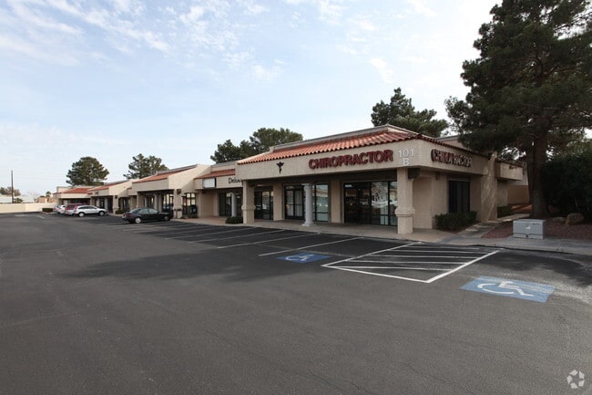
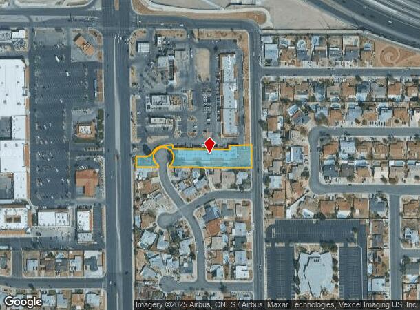
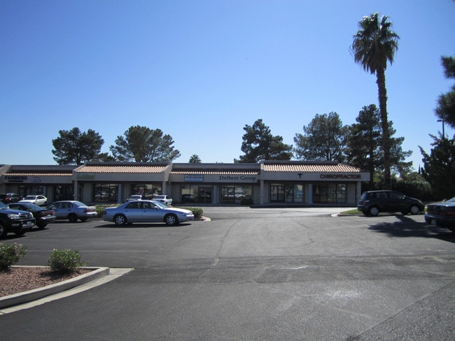
101 S Rainbow Blvd
Las Vegas-Henderson-Paradise, NV
Westcliff Shopping Center
138-34-513-008
WESTCLIFF SHOPPING CENTER PLAT BOOK 34 PAGE 83 PT BLOCK 1
Storebuilding
Clark
2024
Nevada
2025
0.88 AC
003005
Central West Las Vegas
14,968 SF
Las Vegas
DEMOGRAPHICS near 101 S Rainbow Blvd
1 Mile
3 Mile
5 Mile
2024 Total Population
28,401
181,703
488,621
2029 Population
30,357
194,826
524,153
Pop Growth 2024-2029
+ 6.89%
+ 7.22%
+ 7.27%
Average Age
38
39
40
2024 Total Households
10,155
68,891
190,563
HH Growth 2024-2029
+ 6.85%
+ 7.23%
+ 7.29%
Median Household Inc
$51,701
$50,578
$54,489
Avg Household Size
2.70
2.50
2.50
2024 Avg HH Vehicles
2.00
2.00
2.00
Median Home Value
$253,946
$294,485
$343,707
Median Year Built
1979
1986
1990
Nearby Places
Map Layers
Map Styles
 Street
 Aerial
- Restaurants
- Banks
- Shops
- Fitness
- Groceries
PUBLIC TRANSPORTATION
AIRPORT
Harry Reid International
DRIVE
WALK
Distance
Harry Reid International
21 min
12.1 mi
Boulder City Municipal
DRIVE
WALK
Distance
Boulder City Municipal
41 min
32.1 mi
Freight Ports
Port of Long Beach
DRIVE
WALK
Distance
Port of Long Beach
322 min
287.6 mi
SALE & LEASE HISTORY
LISTING DATE
SALE/LEASE

Sep 26, 2017
For Lease
Sep 25, 2016
For Lease
Jan 23, 2017
For Lease
Nearby Properties
Address
Land Use
TOTAL SIZE
Lot Size
Zoning
Address
Land Use
TOTAL SIZE
Lot Size
Zoning
336,142 SF
39.99 AC
PC
Address
Land Use
TOTAL SIZE
Lot Size
Zoning
338,051 SF
49.13 AC
C1
Address
Land Use
TOTAL SIZE
Lot Size
Zoning
974,131 SF
19.93 AC
Address
Land Use
TOTAL SIZE
Lot Size
Zoning
161.14 AC
CV
Address
Land Use
TOTAL SIZE
Lot Size
Zoning
157.50 AC
Address
Land Use
TOTAL SIZE
Lot Size
Zoning
408,908 SF
15.60 AC
Address
Land Use
TOTAL SIZE
Lot Size
Zoning
5,643 SF
10.29 AC
Address
Land Use
TOTAL SIZE
Lot Size
Zoning
37.31 AC
CV
Address
Land Use
TOTAL SIZE
Lot Size
Zoning
7,148 SF
7.26 AC
Address
Land Use
TOTAL SIZE
Lot Size
Zoning
14,793 SF
9.57 AC
CPB
Address
Land Use
TOTAL SIZE
Lot Size
Zoning
28,956 SF
75.82 AC
CV
Address
Land Use
TOTAL SIZE
Lot Size
Zoning
4,872 SF
18.22 AC
R3
Address
Land Use
TOTAL SIZE
Lot Size
Zoning
5,057 SF
9.46 AC
RE
Address
Land Use
TOTAL SIZE
Lot Size
Zoning
8,261 SF
9.36 AC
Address
Land Use
TOTAL SIZE
Lot Size
Zoning
271,484 SF
7.04 AC
C2
Address
Land Use
TOTAL SIZE
Lot Size
Zoning
322,005 SF
29.37 AC
C1
Address
Land Use
TOTAL SIZE
Lot Size
Zoning
181,262 SF
16.63 AC
L:C-2
Address
Land Use
TOTAL SIZE
Lot Size
Zoning
5,750 SF
19.67 AC
R3
Address
Land Use
TOTAL SIZE
Lot Size
Zoning
6,558 SF
23.36 AC
R3
Address
Land Use
TOTAL SIZE
Lot Size
Zoning
52,058 SF
6.44 AC
C1
Address
Land Use
TOTAL SIZE
Lot Size
Zoning
66.57 AC
CV
Address
Land Use
TOTAL SIZE
Lot Size
Zoning
285,929 SF
5.06 AC
C1
Address
Land Use
TOTAL SIZE
Lot Size
Zoning
211,331 SF
6.70 AC
USC
Address
Land Use
TOTAL SIZE
Lot Size
Zoning
6,280 SF
8.72 AC
RPD18
Address
Land Use
TOTAL SIZE
Lot Size
Zoning
Address
Land Use
TOTAL SIZE
Lot Size
Zoning
99,487 SF
22.61 AC
PC
Address
Land Use
TOTAL SIZE
Lot Size
Zoning
7,148 SF
15.33 AC
L:R-PD20
Address
Land Use
TOTAL SIZE
Lot Size
Zoning
1,838 SF
24.69 AC
R3
The World's #1 Commercial Real Estate Marketplace
Connect with us
© 2025 CoStar Group
The information above has been obtained from sources believed reliable. While we do not doubt its accuracy we have not verified it and make no guarantee, warranty or representation about it. It is your responsibility to independently confirm its accuracy and completeness. Any projections, opinions, assumptions, or estimates used are for example only and do not represent the current or future performance of the property. The value of this transaction to you depends on tax and other factors which should be evaluated by your tax, financial, and legal advisors. You and your advisors should conduct a careful, independent investigation of the property to determine to your satisfaction the suitability of the property for your needs.