Property Record
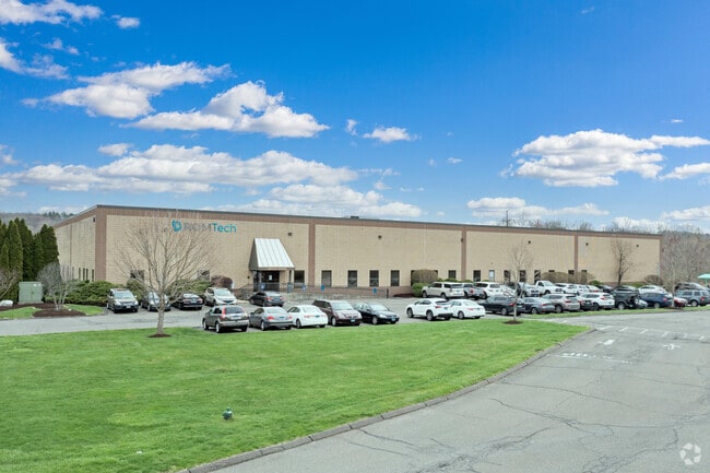
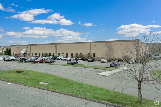
101 Silvermine Rd, Brookfield, CT 06804

Property Detail
101 Silvermine Rd
BROO-000010D-000000-000001
Western Ct
Industrialgeneral
Connecticut
I-1
1
AE The base floodplain where base flood elevations are provided. AE Zones are now used on new format FIRMs instead of A1-A30 Zones.
9.41 AC
2025
Brookfield
2025
Westchester/So Connecticut
205300
Bridgeport-Stamford-Danbury, CT
99,524 SF
NEARBY LISTINGS FOR SALE OR LEASE
DEMOGRAPHICS near 101 Silvermine Rd
1 mile
3 mile
5 mile
2025 Total Population
3,808
25,598
69,907
2030 Population
3,940
26,532
71,909
Pop Growth 2025-2030
+ 3.47%
+ 3.65%
+ 2.86%
Average Age
43
44
43
2025 Total Households
1,440
9,959
25,831
HH Growth 2025-2030
+ 3.40%
+ 3.59%
+ 2.87%
Median Household Inc
$130,151
$134,313
$117,578
Avg Household Size
2.60
2.50
2.60
2025 Avg HH Vehicles
2.00
2.00
2.00
Median Home Value
$475,480
$460,899
$448,565
Median Year Built
1977
1976
1975
Nearby Places
Map Layers
Map Styles
 Street
 Aerial
Layers
 Traffic
 Biking
Places
Listings with unknown addresses are not visible on the map
- Restaurants
- Banks
- Shops
- Fitness
- Groceries
PUBLIC TRANSPORTATION
COMMUTER RAIL
Danbury Station (New Haven Line - Metro-North Commuter Railroad Company (Metro-North))
Drive
Walk
Distance
Danbury Station (New Haven Line - Metro-North Commuter Railroad Company (Metro-North))
15 min
6.5 mi
Bethel Station (New Haven Line - Metro-North Commuter Railroad Company (Metro-North))
Drive
Walk
Distance
Bethel Station (New Haven Line - Metro-North Commuter Railroad Company (Metro-North))
19 min
7.9 mi
AIRPORT
Tweed/New Haven
Drive
Walk
Distance
Tweed/New Haven
61 min
37.8 mi
Westchester County
Drive
Walk
Distance
Westchester County
53 min
40.2 mi
Freight Ports
Port of New Haven
Drive
Walk
Distance
Port of New Haven
56 min
34.9 mi
SALE & LEASE HISTORY
LISTING DATE
SALE/LEASE

Sep 04, 2018
For Lease
Nearby Properties
Address
Land Use
TOTAL SIZE
Lot Size
Zoning
Address
Land Use
TOTAL SIZE
Lot Size
Zoning
168,282 SF
22.83 AC
R-60
Address
Land Use
TOTAL SIZE
Lot Size
Zoning
322,970 SF
43.80 AC
IP
Address
Land Use
TOTAL SIZE
Lot Size
Zoning
31.57 AC
C-1
Address
Land Use
TOTAL SIZE
Lot Size
Zoning
79.31 AC
R-80
Address
Land Use
TOTAL SIZE
Lot Size
Zoning
139,231 SF
13.31 AC
CP
Address
Land Use
TOTAL SIZE
Lot Size
Zoning
172,288 SF
14.99 AC
IL40
Address
Land Use
TOTAL SIZE
Lot Size
Zoning
4.09 AC
C-1
Address
Land Use
TOTAL SIZE
Lot Size
Zoning
9.39 AC
C-2
Address
Land Use
TOTAL SIZE
Lot Size
Zoning
Address
Land Use
TOTAL SIZE
Lot Size
Zoning
111,660 SF
8.99 AC
CG20
Address
Land Use
TOTAL SIZE
Lot Size
Zoning
16.31 AC
C-1
Address
Land Use
TOTAL SIZE
Lot Size
Zoning
123,271 SF
16.06 AC
C-1
Address
Land Use
TOTAL SIZE
Lot Size
Zoning
127,863 SF
12.82 AC
R-20
Address
Land Use
TOTAL SIZE
Lot Size
Zoning
45.15 AC
I-1 HO
Address
Land Use
TOTAL SIZE
Lot Size
Zoning
12.42 AC
C-1
Address
Land Use
TOTAL SIZE
Lot Size
Zoning
16.09 AC
R-80
Address
Land Use
TOTAL SIZE
Lot Size
Zoning
15.93 AC
RA40
Address
Land Use
TOTAL SIZE
Lot Size
Zoning
77,492 SF
30.25 AC
Address
Land Use
TOTAL SIZE
Lot Size
Zoning
6.18 AC
R-60
Address
Land Use
TOTAL SIZE
Lot Size
Zoning
65,027 SF
5.69 AC
C-1
Address
Land Use
TOTAL SIZE
Lot Size
Zoning
106,315 SF
12.52 AC
CG20
Address
Land Use
TOTAL SIZE
Lot Size
Zoning
2,173 SF
4.76 AC
TCD
Address
Land Use
TOTAL SIZE
Lot Size
Zoning
53,582 SF
7.71 AC
C-2
Address
Land Use
TOTAL SIZE
Lot Size
Zoning
2,295.68 AC
Address
Land Use
TOTAL SIZE
Lot Size
Zoning
6.54 AC
TCD-P
Address
Land Use
TOTAL SIZE
Lot Size
Zoning
151,200 SF
12.48 AC
I-1
Address
Land Use
TOTAL SIZE
Lot Size
Zoning
6.87 AC
C-1
Address
Land Use
TOTAL SIZE
Lot Size
Zoning
110,200 SF
4.96 AC
I-1 HO
Address
Land Use
TOTAL SIZE
Lot Size
Zoning
99,891 SF
7.01 AC
C-1
Address
Land Use
TOTAL SIZE
Lot Size
Zoning
9.29 AC
R-60
The World's #1 Commercial Real Estate Marketplace
Connect with us
© 2026 CoStar Group
The information above has been obtained from sources believed reliable. While we do not doubt its accuracy we have not verified it and make no guarantee, warranty or representation about it. It is your responsibility to independently confirm its accuracy and completeness. Any projections, opinions, assumptions, or estimates used are for example only and do not represent the current or future performance of the property. The value of this transaction to you depends on tax and other factors which should be evaluated by your tax, financial, and legal advisors. You and your advisors should conduct a careful, independent investigation of the property to determine to your satisfaction the suitability of the property for your needs.