Property Record
1010 W 37Th Pl, Tulsa, OK 74107
NEARBY LISTINGS FOR SALE OR LEASE
Property Detail
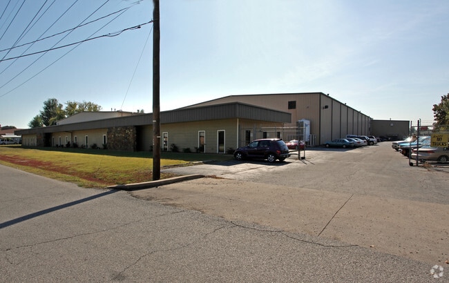
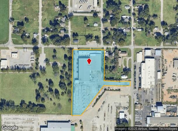
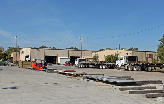
1010 W 37Th Pl
99223-92-23-11430
Unplatted
Lightindustrial
PRT S/2 SEC BEG 240N & 140W SECR NE SW TH W347.5 S719.75 E100 NE411.03 E280 N50 W280 N340 POB SEC 23 19 12 5.13ACS
X
Tulsa
40143C0332L
Oklahoma
2025
5.13 AC
2025
West Tulsa
004900
Tulsa
59,795 SF
Tulsa, OK
DEMOGRAPHICS near 1010 W 37Th Pl
1 Mile
3 Mile
5 Mile
2024 Total Population
2,097
54,579
161,404
2029 Population
2,197
56,725
168,052
Pop Growth 2024-2029
+ 4.77%
+ 3.93%
+ 4.12%
Average Age
40
40
39
2024 Total Households
867
26,204
72,428
HH Growth 2024-2029
+ 4.73%
+ 4.12%
+ 4.26%
Median Household Inc
$47,621
$53,738
$53,012
Avg Household Size
2.30
2.00
2.10
2024 Avg HH Vehicles
2.00
2.00
2.00
Median Home Value
$86,956
$216,601
$194,736
Median Year Built
1959
1964
1965
Nearby Places
Map Layers
Map Styles
 Street
 Aerial
- Restaurants
- Banks
- Shops
- Fitness
- Groceries
PUBLIC TRANSPORTATION
AIRPORT
Tulsa International
DRIVE
WALK
Distance
Tulsa International
21 min
13.7 mi
Freight Ports
Tulsa Port Of Catoosa
DRIVE
WALK
Distance
Tulsa Port Of Catoosa
31 min
23.0 mi
Nearby Properties
Address
Land Use
TOTAL SIZE
Lot Size
Zoning
Address
Land Use
TOTAL SIZE
Lot Size
Zoning
1,303,210 SF
7.94 AC
OH
Address
Land Use
TOTAL SIZE
Lot Size
Zoning
249,092 SF
11.75 AC
CBD
Address
Land Use
TOTAL SIZE
Lot Size
Zoning
483,697 SF
5.31 AC
CBD
Address
Land Use
TOTAL SIZE
Lot Size
Zoning
247,806 SF
8.40 AC
RS3
Address
Land Use
TOTAL SIZE
Lot Size
Zoning
49,992 SF
33.23 AC
AG
Address
Land Use
TOTAL SIZE
Lot Size
Zoning
132,305 SF
2.07 AC
CBD
Address
Land Use
TOTAL SIZE
Lot Size
Zoning
114,791 SF
23.40 AC
RE
Address
Land Use
TOTAL SIZE
Lot Size
Zoning
238,884 SF
38.79 AC
RS2
Address
Land Use
TOTAL SIZE
Lot Size
Zoning
290,963 SF
10.77 AC
RM1
Address
Land Use
TOTAL SIZE
Lot Size
Zoning
303 SF
33.64 AC
RS2
Address
Land Use
TOTAL SIZE
Lot Size
Zoning
124,033 SF
4.18 AC
CBD
Address
Land Use
TOTAL SIZE
Lot Size
Zoning
315,434 SF
2.07 AC
CBD
Address
Land Use
TOTAL SIZE
Lot Size
Zoning
266,675 SF
12.31 AC
RM1
Address
Land Use
TOTAL SIZE
Lot Size
Zoning
119,056 SF
28.06 AC
CM
Address
Land Use
TOTAL SIZE
Lot Size
Zoning
84,560 SF
1.92 AC
CBD
Address
Land Use
TOTAL SIZE
Lot Size
Zoning
137,215 SF
5.08 AC
RM3
Address
Land Use
TOTAL SIZE
Lot Size
Zoning
236,413 SF
2.07 AC
CBD
Address
Land Use
TOTAL SIZE
Lot Size
Zoning
112,506 SF
2.14 AC
CBD
Address
Land Use
TOTAL SIZE
Lot Size
Zoning
88,702 SF
8.27 AC
IM
Address
Land Use
TOTAL SIZE
Lot Size
Zoning
21,693 SF
4.24 AC
Address
Land Use
TOTAL SIZE
Lot Size
Zoning
149,830 SF
0.83 AC
CBD
Address
Land Use
TOTAL SIZE
Lot Size
Zoning
106,743 SF
4.34 AC
MX1U55
Address
Land Use
TOTAL SIZE
Lot Size
Zoning
89,640 SF
5.47 AC
MX1U55
Address
Land Use
TOTAL SIZE
Lot Size
Zoning
100,857 SF
4.04 AC
MX1U55
Address
Land Use
TOTAL SIZE
Lot Size
Zoning
105,620 SF
2.55 AC
RM2
Address
Land Use
TOTAL SIZE
Lot Size
Zoning
132,105 SF
9.32 AC
RS3
Address
Land Use
TOTAL SIZE
Lot Size
Zoning
28,953 SF
10.32 AC
RS2
Address
Land Use
TOTAL SIZE
Lot Size
Zoning
78,442 SF
31.24 AC
IM
Address
Land Use
TOTAL SIZE
Lot Size
Zoning
495,226 SF
27.47 AC
CH
Address
Land Use
TOTAL SIZE
Lot Size
Zoning
53,220 SF
4.93 AC
CH
The World's #1 Commercial Real Estate Marketplace
Connect with us
© 2025 CoStar Group
The information above has been obtained from sources believed reliable. While we do not doubt its accuracy we have not verified it and make no guarantee, warranty or representation about it. It is your responsibility to independently confirm its accuracy and completeness. Any projections, opinions, assumptions, or estimates used are for example only and do not represent the current or future performance of the property. The value of this transaction to you depends on tax and other factors which should be evaluated by your tax, financial, and legal advisors. You and your advisors should conduct a careful, independent investigation of the property to determine to your satisfaction the suitability of the property for your needs.