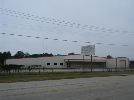
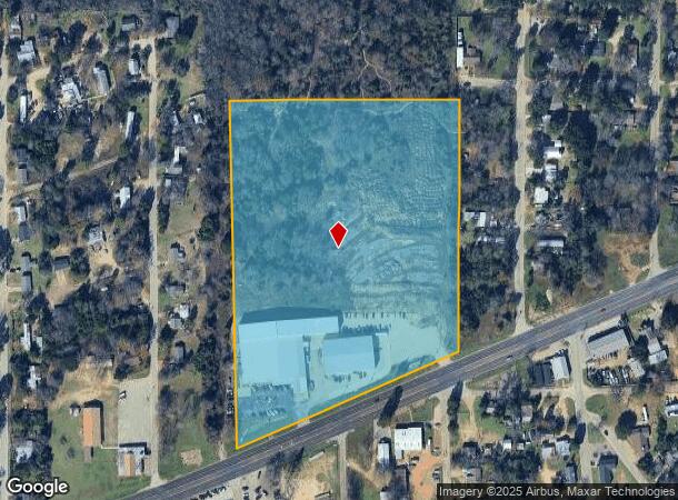
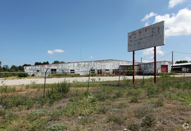
Property Record
1010 W Corsicana St, Athens, TX 75751
NEARBY LISTINGS FOR SALE OR LEASE
-
-
View all Athens listings for sale on LoopNet.com
Property Detail
1010 W Corsicana St
Athens, TX
T Parmer Sur
0782-0110-0000-01
AB 782 T PARMER SUR, TR 11 (RE:TRS 10-12) (RE:LT 5D) REPLAT G/145
Commercialnec
Henderson
X
Texas
48213C0310E
5d
2024
13.25 AC
2025
Henderson County
951202
Dallas/Ft Worth
21,000 SF
DEMOGRAPHICS near 1010 W Corsicana St
1 Mile
3 Mile
5 Mile
2024 Total Population
3,041
12,782
16,490
2029 Population
3,220
13,580
17,484
Pop Growth 2024-2029
+ 5.89%
+ 6.24%
+ 6.03%
Average Age
35
39
40
2024 Total Households
984
4,658
6,074
HH Growth 2024-2029
+ 5.69%
+ 6.10%
+ 5.88%
Median Household Inc
$42,840
$45,561
$48,588
Avg Household Size
2.80
2.50
2.50
2024 Avg HH Vehicles
2.00
2.00
2.00
Median Home Value
$65,789
$147,790
$156,922
Median Year Built
1969
1977
1979
Nearby Places
Map Layers
Map Styles
 Street
 Aerial
- Restaurants
- Banks
- Shops
- Fitness
- Groceries
PUBLIC TRANSPORTATION
AIRPORT
Tyler Pounds Regional
DRIVE
WALK
Distance
Tyler Pounds Regional
47 min
34.9 mi
Freight Ports
Port of Shreveport
DRIVE
WALK
Distance
Port of Shreveport
167 min
143.7 mi
Nearby Properties
Address
Land Use
TOTAL SIZE
Lot Size
Zoning
Address
Land Use
TOTAL SIZE
Lot Size
Zoning
119,750 SF
37.85 AC
Address
Land Use
TOTAL SIZE
Lot Size
Zoning
40.91 AC
Address
Land Use
TOTAL SIZE
Lot Size
Zoning
8.02 AC
Address
Land Use
TOTAL SIZE
Lot Size
Zoning
43,612 SF
15.43 AC
Address
Land Use
TOTAL SIZE
Lot Size
Zoning
702,506 SF
35 AC
Address
Land Use
TOTAL SIZE
Lot Size
Zoning
2,254.90 AC
Address
Land Use
TOTAL SIZE
Lot Size
Zoning
1.02 AC
Address
Land Use
TOTAL SIZE
Lot Size
Zoning
49,353 SF
37.85 AC
Address
Land Use
TOTAL SIZE
Lot Size
Zoning
187,307 SF
24.76 AC
Address
Land Use
TOTAL SIZE
Lot Size
Zoning
14,475 SF
12.39 AC
Address
Land Use
TOTAL SIZE
Lot Size
Zoning
17.50 AC
Address
Land Use
TOTAL SIZE
Lot Size
Zoning
29,984 SF
7.79 AC
Address
Land Use
TOTAL SIZE
Lot Size
Zoning
47,400 SF
15.33 AC
Address
Land Use
TOTAL SIZE
Lot Size
Zoning
69,056 SF
16.02 AC
Address
Land Use
TOTAL SIZE
Lot Size
Zoning
32,077 SF
0.25 AC
Address
Land Use
TOTAL SIZE
Lot Size
Zoning
83,122 SF
5.42 AC
Address
Land Use
TOTAL SIZE
Lot Size
Zoning
38,975 SF
4.61 AC
Address
Land Use
TOTAL SIZE
Lot Size
Zoning
40,549 SF
9.36 AC
Address
Land Use
TOTAL SIZE
Lot Size
Zoning
28,963 SF
10.11 AC
Address
Land Use
TOTAL SIZE
Lot Size
Zoning
20,883 SF
4.40 AC
Address
Land Use
TOTAL SIZE
Lot Size
Zoning
22,958 SF
1.94 AC
Address
Land Use
TOTAL SIZE
Lot Size
Zoning
151,225 SF
Address
Land Use
TOTAL SIZE
Lot Size
Zoning
64,650 SF
11.56 AC
Address
Land Use
TOTAL SIZE
Lot Size
Zoning
25,962 SF
4.23 AC
Address
Land Use
TOTAL SIZE
Lot Size
Zoning
17,262 SF
17.41 AC
Address
Land Use
TOTAL SIZE
Lot Size
Zoning
11,381 SF
1.87 AC
Address
Land Use
TOTAL SIZE
Lot Size
Zoning
52,792 SF
22.40 AC
Address
Land Use
TOTAL SIZE
Lot Size
Zoning
47,204 SF
5.61 AC
Address
Land Use
TOTAL SIZE
Lot Size
Zoning
19,505 SF
24.43 AC
Address
Land Use
TOTAL SIZE
Lot Size
Zoning
46,283 SF
2.67 AC
The World's #1 Commercial Real Estate Marketplace
Connect with us
© 2026 CoStar Group
The information above has been obtained from sources believed reliable. While we do not doubt its accuracy we have not verified it and make no guarantee, warranty or representation about it. It is your responsibility to independently confirm its accuracy and completeness. Any projections, opinions, assumptions, or estimates used are for example only and do not represent the current or future performance of the property. The value of this transaction to you depends on tax and other factors which should be evaluated by your tax, financial, and legal advisors. You and your advisors should conduct a careful, independent investigation of the property to determine to your satisfaction the suitability of the property for your needs.