Property Record
1011 Depot Hill Rd, Broomfield, CO 80020
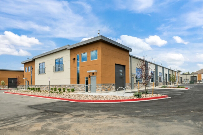
This Property Is For Sale
Current Lease Availabilities
NEARBY LISTINGS FOR SALE OR LEASE
Property Detail
1011 Depot Hill Rd
Denver-Aurora-Lakewood, CO
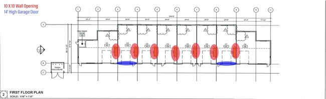
Flex Space At Depot Hill Condos
1575-27-4-31-028
SUBD: FLEX SPACE AT DEPOT HILL CONDOS UNIT: C3 S: 27 T: 1S R: 69W DESC: COMMON ALLOCATION 3.21%
Commercialcondominium
Broomfield
0
Colorado
2025
Broomfield County
031202
Denver
1,086 SF
DEMOGRAPHICS near 1011 Depot Hill Rd
1 Mile
3 Mile
5 Mile
2024 Total Population
8,686
62,570
191,245
2029 Population
9,369
66,462
197,571
Pop Growth 2024-2029
+ 7.86%
+ 6.22%
+ 3.31%
Average Age
41
39
40
2024 Total Households
3,594
25,968
76,662
HH Growth 2024-2029
+ 7.71%
+ 6.48%
+ 3.40%
Median Household Inc
$95,084
$99,072
$105,769
Avg Household Size
2.40
2.40
2.40
2024 Avg HH Vehicles
2.00
2.00
2.00
Median Home Value
$458,910
$498,287
$585,223
Median Year Built
1976
1995
1993
Nearby Places
Map Layers
Map Styles
 Street
 Aerial
- Restaurants
- Banks
- Shops
- Fitness
- Groceries
PUBLIC TRANSPORTATION
COMMUTER RAIL
Eastlake - 124Th Station Track 2 (Union Station to Eastlake & 124th Station - Regional Transportation District)
DRIVE
WALK
Distance
Eastlake - 124Th Station Track 2 (Union Station to Eastlake & 124th Station - Regional Transportation District)
16 min
8.6 mi
Northglenn - 112Th Station Track 2 (Union Station to Eastlake & 124th Station - Regional Transportation District)
DRIVE
WALK
Distance
Northglenn - 112Th Station Track 2 (Union Station to Eastlake & 124th Station - Regional Transportation District)
18 min
9.2 mi
AIRPORT
Denver International
DRIVE
WALK
Distance
Denver International
37 min
32.5 mi
Freight Ports
Tulsa Port Of Catoosa
DRIVE
WALK
Distance
Tulsa Port Of Catoosa
740 min
719.1 mi
Nearby Properties
Address
Land Use
TOTAL SIZE
Lot Size
Zoning
Address
Land Use
TOTAL SIZE
Lot Size
Zoning
420,330 SF
41.96 AC
A
Address
Land Use
TOTAL SIZE
Lot Size
Zoning
776,625 SF
41.29 AC
PUD
Address
Land Use
TOTAL SIZE
Lot Size
Zoning
431,902 SF
17.63 AC
Address
Land Use
TOTAL SIZE
Lot Size
Zoning
62.60 AC
Address
Land Use
TOTAL SIZE
Lot Size
Zoning
305,331 SF
14.41 AC
PUD
Address
Land Use
TOTAL SIZE
Lot Size
Zoning
117,775 SF
34.58 AC
GA; PUD
Address
Land Use
TOTAL SIZE
Lot Size
Zoning
211,191 SF
30.46 AC
Address
Land Use
TOTAL SIZE
Lot Size
Zoning
254,500 SF
13.42 AC
PUD
Address
Land Use
TOTAL SIZE
Lot Size
Zoning
279.72 AC
A
Address
Land Use
TOTAL SIZE
Lot Size
Zoning
188,092 SF
2.01 AC
Address
Land Use
TOTAL SIZE
Lot Size
Zoning
233.17 AC
A
Address
Land Use
TOTAL SIZE
Lot Size
Zoning
320,771 SF
18.60 AC
PUD
Address
Land Use
TOTAL SIZE
Lot Size
Zoning
254,500 SF
13 AC
PUD
Address
Land Use
TOTAL SIZE
Lot Size
Zoning
130,769 SF
18.61 AC
PUD
Address
Land Use
TOTAL SIZE
Lot Size
Zoning
643,992 SF
13.24 AC
PUD
Address
Land Use
TOTAL SIZE
Lot Size
Zoning
174,398 SF
33.34 AC
PF; PROL;
Address
Land Use
TOTAL SIZE
Lot Size
Zoning
120,510 SF
11.02 AC
Address
Land Use
TOTAL SIZE
Lot Size
Zoning
212,852 SF
12.82 AC
Address
Land Use
TOTAL SIZE
Lot Size
Zoning
187,920 SF
10.57 AC
PUD
Address
Land Use
TOTAL SIZE
Lot Size
Zoning
153,430 SF
12.16 AC
Address
Land Use
TOTAL SIZE
Lot Size
Zoning
281,167 SF
19.52 AC
Address
Land Use
TOTAL SIZE
Lot Size
Zoning
159,724 SF
8.11 AC
Address
Land Use
TOTAL SIZE
Lot Size
Zoning
577,088 SF
18.94 AC
PUD
Address
Land Use
TOTAL SIZE
Lot Size
Zoning
137,435 SF
9.49 AC
Address
Land Use
TOTAL SIZE
Lot Size
Zoning
22.16 AC
Address
Land Use
TOTAL SIZE
Lot Size
Zoning
214,678 SF
10.46 AC
Address
Land Use
TOTAL SIZE
Lot Size
Zoning
113,473 SF
8.59 AC
Address
Land Use
TOTAL SIZE
Lot Size
Zoning
453,015 SF
12.10 AC
B-PUD
Address
Land Use
TOTAL SIZE
Lot Size
Zoning
165,172 SF
11.12 AC
Address
Land Use
TOTAL SIZE
Lot Size
Zoning
154,700 SF
9.03 AC
PUD
The World's #1 Commercial Real Estate Marketplace
Connect with us
© 2026 CoStar Group
The information above has been obtained from sources believed reliable. While we do not doubt its accuracy we have not verified it and make no guarantee, warranty or representation about it. It is your responsibility to independently confirm its accuracy and completeness. Any projections, opinions, assumptions, or estimates used are for example only and do not represent the current or future performance of the property. The value of this transaction to you depends on tax and other factors which should be evaluated by your tax, financial, and legal advisors. You and your advisors should conduct a careful, independent investigation of the property to determine to your satisfaction the suitability of the property for your needs.