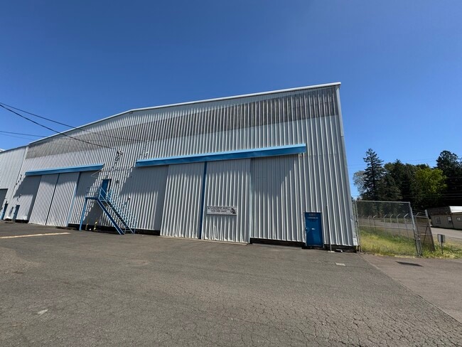
Property Record
10120 Sw North Dakota St, Portland, OR 97223

Current Lease Availabilities
NEARBY LISTINGS FOR SALE OR LEASE
Property Detail
10120 Sw North Dakota St
Portland-Vancouver-Hillsboro, OR-WA
217 Corridor
R0273402
ACRES 4.50
Commercialbuilding
Washington
AE
Oregon
41067C0533E
4.50 AC
2024
Tigard
2026
Portland
030900
DEMOGRAPHICS near 10120 Sw North Dakota St
1 Mile
3 Mile
5 Mile
2024 Total Population
14,546
138,157
313,739
2029 Population
14,670
138,707
314,906
Pop Growth 2024-2029
+ 0.85%
+ 0.40%
+ 0.37%
Average Age
39
41
41
2024 Total Households
5,778
56,718
126,944
HH Growth 2024-2029
+ 0.87%
+ 0.40%
+ 0.34%
Median Household Inc
$79,540
$91,154
$94,734
Avg Household Size
2.50
2.40
2.40
2024 Avg HH Vehicles
2.00
2.00
2.00
Median Home Value
$462,995
$529,218
$596,060
Median Year Built
1977
1983
1982
Nearby Places
Map Layers
Map Styles
 Street
 Aerial
- Restaurants
- Banks
- Shops
- Fitness
- Groceries
PUBLIC TRANSPORTATION
COMMUTER RAIL
Tigard Transit Center (Westside Express Service - Tri-County Metropolitan Transportation District of Oregon Rail (TriMet Rail))
DRIVE
WALK
Distance
Tigard Transit Center (Westside Express Service - Tri-County Metropolitan Transportation District of Oregon Rail (TriMet Rail))
4 min
18 min
1.0 mi
Hall/Nimbus (Westside Express Service - Tri-County Metropolitan Transportation District of Oregon Rail (TriMet Rail))
DRIVE
WALK
Distance
Hall/Nimbus (Westside Express Service - Tri-County Metropolitan Transportation District of Oregon Rail (TriMet Rail))
5 min
2.0 mi
AIRPORT
Portland International
DRIVE
WALK
Distance
Portland International
35 min
21.7 mi
Freight Ports
Port of Portland
DRIVE
WALK
Distance
Port of Portland
21 min
12.9 mi
Nearby Properties
Address
Land Use
TOTAL SIZE
Lot Size
Zoning
Address
Land Use
TOTAL SIZE
Lot Size
Zoning
49.34 AC
I-P
Address
Land Use
TOTAL SIZE
Lot Size
Zoning
828,566 SF
54.77 AC
CI2
Address
Land Use
TOTAL SIZE
Lot Size
Zoning
1 SF
16 AC
R-5
Address
Land Use
TOTAL SIZE
Lot Size
Zoning
43.20 AC
R-4.5
Address
Land Use
TOTAL SIZE
Lot Size
Zoning
14.77 AC
MUE
Address
Land Use
TOTAL SIZE
Lot Size
Zoning
213,947 SF
14.45 AC
TC-MU
Address
Land Use
TOTAL SIZE
Lot Size
Zoning
88,000 SF
15.49 AC
R-4.5
Address
Land Use
TOTAL SIZE
Lot Size
Zoning
256,070 SF
32.39 AC
R7
Address
Land Use
TOTAL SIZE
Lot Size
Zoning
6 AC
MC
Address
Land Use
TOTAL SIZE
Lot Size
Zoning
43,537 SF
3.59 AC
MUC
Address
Land Use
TOTAL SIZE
Lot Size
Zoning
183,133 SF
8.17 AC
R-25
Address
Land Use
TOTAL SIZE
Lot Size
Zoning
11,736 SF
2.85 AC
MUE-1
Address
Land Use
TOTAL SIZE
Lot Size
Zoning
285,650 SF
26.94 AC
INST
Address
Land Use
TOTAL SIZE
Lot Size
Zoning
158,824 SF
20.71 AC
CC
Address
Land Use
TOTAL SIZE
Lot Size
Zoning
423,095 SF
21.51 AC
R1
Address
Land Use
TOTAL SIZE
Lot Size
Zoning
88,000 SF
12.62 AC
R-4.5
Address
Land Use
TOTAL SIZE
Lot Size
Zoning
128,176 SF
25.06 AC
R7
Address
Land Use
TOTAL SIZE
Lot Size
Zoning
20.98 AC
R5
Address
Land Use
TOTAL SIZE
Lot Size
Zoning
4,046 SF
4.08 AC
MUE-1
Address
Land Use
TOTAL SIZE
Lot Size
Zoning
301,940 SF
15.04 AC
MU-CBD
Address
Land Use
TOTAL SIZE
Lot Size
Zoning
87,200 SF
8.81 AC
R7
Address
Land Use
TOTAL SIZE
Lot Size
Zoning
517,403 SF
3.21 AC
MUE-1
Address
Land Use
TOTAL SIZE
Lot Size
Zoning
140,938 SF
7.02 AC
C-WS
Address
Land Use
TOTAL SIZE
Lot Size
Zoning
3.88 AC
CS
Address
Land Use
TOTAL SIZE
Lot Size
Zoning
Address
Land Use
TOTAL SIZE
Lot Size
Zoning
227,772 SF
17.32 AC
R5
Address
Land Use
TOTAL SIZE
Lot Size
Zoning
209,706 SF
4.89 AC
MUC
Address
Land Use
TOTAL SIZE
Lot Size
Zoning
157,885 SF
9.88 AC
R-25
Address
Land Use
TOTAL SIZE
Lot Size
Zoning
121,664 SF
11.65 AC
C-G
Address
Land Use
TOTAL SIZE
Lot Size
Zoning
0.09 AC
OI-WS
The World's #1 Commercial Real Estate Marketplace
Connect with us
© 2026 CoStar Group
The information above has been obtained from sources believed reliable. While we do not doubt its accuracy we have not verified it and make no guarantee, warranty or representation about it. It is your responsibility to independently confirm its accuracy and completeness. Any projections, opinions, assumptions, or estimates used are for example only and do not represent the current or future performance of the property. The value of this transaction to you depends on tax and other factors which should be evaluated by your tax, financial, and legal advisors. You and your advisors should conduct a careful, independent investigation of the property to determine to your satisfaction the suitability of the property for your needs.