Property Record
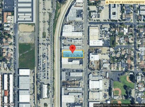
10121 Canoga Ave, Chatsworth, CA 91311


Current Lease Availabilities
NEARBY LISTINGS FOR SALE OR LEASE
Property Detail
10121 Canoga Ave
Los Angeles-Long Beach-Glendale, CA
Chatsworth
2747-010-024
CHATSWORTH PARK THAT PART EX OF ST E OF BROWN'S CREEK PER FM 20054-2 OF N 100 FTOF S 300 FT OF LOTS 87 AND 88 IN SEC 18 T 2N R 16W
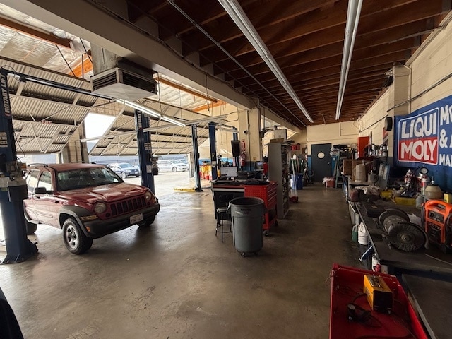
Autorepair
Los Angeles
AO
California
06037C1040F
87,88
2024
0.66 AC
2025
West San Fernando Valley
113323
Los Angeles
11,040 SF
DEMOGRAPHICS near 10121 Canoga Ave
1 Mile
3 Mile
5 Mile
2024 Total Population
21,122
112,129
349,774
2029 Population
20,678
109,730
341,707
Pop Growth 2024-2029
(2.10%)
(2.14%)
(2.31%)
Average Age
42
42
41
2024 Total Households
7,606
38,108
118,715
HH Growth 2024-2029
(2.33%)
(2.37%)
(2.41%)
Median Household Inc
$97,646
$95,842
$89,239
Avg Household Size
2.70
2.90
2.80
2024 Avg HH Vehicles
2.00
2.00
2.00
Median Home Value
$731,029
$771,693
$762,759
Median Year Built
1974
1974
1973
Nearby Places
Map Layers
Map Styles
 Street
 Aerial
- Restaurants
- Banks
- Shops
- Fitness
- Groceries
PUBLIC TRANSPORTATION
TRANSIT/SUBWAY
Chatsworth (Ventura County Line - Southern California Regional Rail Authority (Metrolink))
DRIVE
WALK
Distance
Chatsworth (Ventura County Line - Southern California Regional Rail Authority (Metrolink))
3 min
12 min
0.6 mi
COMMUTER RAIL
Chatsworth (Ventura County Line - Southern California Regional Rail Authority (Metrolink))
DRIVE
WALK
Distance
Chatsworth (Ventura County Line - Southern California Regional Rail Authority (Metrolink))
3 min
12 min
0.6 mi
Northridge (Ventura County Line - Southern California Regional Rail Authority (Metrolink))
DRIVE
WALK
Distance
Northridge (Ventura County Line - Southern California Regional Rail Authority (Metrolink))
12 min
5.0 mi
AIRPORT
Bob Hope
DRIVE
WALK
Distance
Bob Hope
27 min
18.0 mi
Los Angeles International
DRIVE
WALK
Distance
Los Angeles International
46 min
33.8 mi
Freight Ports
The Port of Hueneme
DRIVE
WALK
Distance
The Port of Hueneme
63 min
42.2 mi
Nearby Properties
Address
Land Use
TOTAL SIZE
Lot Size
Zoning
Address
Land Use
TOTAL SIZE
Lot Size
Zoning
546,652 SF
4.27 AC
LAC2
Address
Land Use
TOTAL SIZE
Lot Size
Zoning
143,806 SF
23.03 AC
LACM
Address
Land Use
TOTAL SIZE
Lot Size
Zoning
354,762 SF
5.05 AC
LAC2
Address
Land Use
TOTAL SIZE
Lot Size
Zoning
805,833 SF
9.02 AC
LAC4
Address
Land Use
TOTAL SIZE
Lot Size
Zoning
539,022 SF
35.67 AC
LAMR2
Address
Land Use
TOTAL SIZE
Lot Size
Zoning
219,083 SF
23.03 AC
LACM
Address
Land Use
TOTAL SIZE
Lot Size
Zoning
158,172 SF
13.23 AC
LAC4
Address
Land Use
TOTAL SIZE
Lot Size
Zoning
298,782 SF
8.63 AC
LAR3
Address
Land Use
TOTAL SIZE
Lot Size
Zoning
260,991 SF
3.32 AC
LAC2
Address
Land Use
TOTAL SIZE
Lot Size
Zoning
304,209 SF
11.31 AC
LAMR2
Address
Land Use
TOTAL SIZE
Lot Size
Zoning
143,044 SF
23.17 AC
LAC4
Address
Land Use
TOTAL SIZE
Lot Size
Zoning
216,121 SF
6.10 AC
LAC4
Address
Land Use
TOTAL SIZE
Lot Size
Zoning
334,428 SF
9.25 AC
LAC4
Address
Land Use
TOTAL SIZE
Lot Size
Zoning
281,941 SF
9.10 AC
LAC4
Address
Land Use
TOTAL SIZE
Lot Size
Zoning
158,163 SF
3.65 AC
LAR3
Address
Land Use
TOTAL SIZE
Lot Size
Zoning
274,013 SF
15.24 AC
LAA1
Address
Land Use
TOTAL SIZE
Lot Size
Zoning
657,547 SF
6.85 AC
LAC4
Address
Land Use
TOTAL SIZE
Lot Size
Zoning
411,979 SF
15.22 AC
LAC4
Address
Land Use
TOTAL SIZE
Lot Size
Zoning
353,563 SF
9.37 AC
LAC2
Address
Land Use
TOTAL SIZE
Lot Size
Zoning
323,511 SF
7.58 AC
LAC1
Address
Land Use
TOTAL SIZE
Lot Size
Zoning
339,133 SF
13.09 AC
LAC4
Address
Land Use
TOTAL SIZE
Lot Size
Zoning
93,466 SF
11.07 AC
LAC2
Address
Land Use
TOTAL SIZE
Lot Size
Zoning
272,065 SF
7.83 AC
LAMR2
Address
Land Use
TOTAL SIZE
Lot Size
Zoning
210,386 SF
8.33 AC
LAMR2
Address
Land Use
TOTAL SIZE
Lot Size
Zoning
145,243 SF
6.68 AC
LAMR2
Address
Land Use
TOTAL SIZE
Lot Size
Zoning
212,781 SF
16.20 AC
LAM1
Address
Land Use
TOTAL SIZE
Lot Size
Zoning
653,215 SF
15.49 AC
LAC4
Address
Land Use
TOTAL SIZE
Lot Size
Zoning
153,783 SF
5.14 AC
LAC2
The World's #1 Commercial Real Estate Marketplace
Connect with us
© 2026 CoStar Group
The information above has been obtained from sources believed reliable. While we do not doubt its accuracy we have not verified it and make no guarantee, warranty or representation about it. It is your responsibility to independently confirm its accuracy and completeness. Any projections, opinions, assumptions, or estimates used are for example only and do not represent the current or future performance of the property. The value of this transaction to you depends on tax and other factors which should be evaluated by your tax, financial, and legal advisors. You and your advisors should conduct a careful, independent investigation of the property to determine to your satisfaction the suitability of the property for your needs.