Property Record
1017 State Route 17M, Monroe, NY 10950


Save to a Folder
{{folder.Name}}
{{folder.ListingIds.length}} Properties
{{folder.ListingIds.length}} Property
Create a New Folder
Property Detail
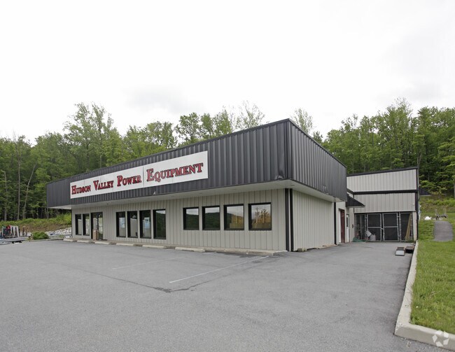
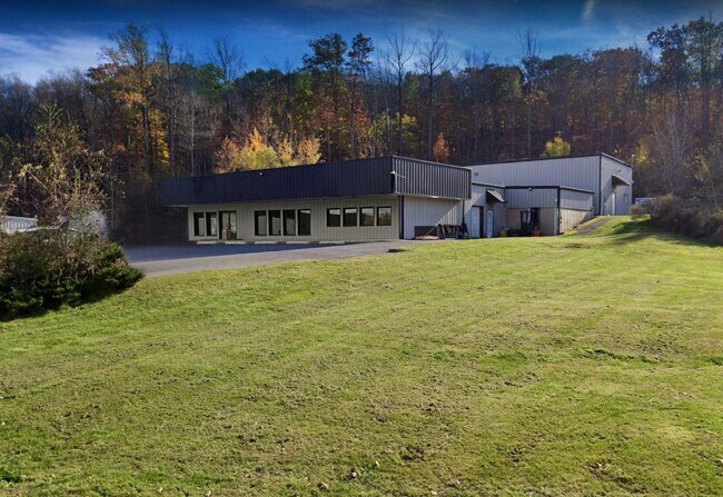
1017 State Route 17M
332089-054-000-0001-035.000-0000
LT 4 BERNARD DAVIS SUB MAP 5316 DEED 11109-1013 7/7/03
Commercialnec
Orange
05
New York
B and X Area of moderate flood hazard, usually the area between the limits of the 100-year and 500-year floods.
35.00
2024
5 AC
2025
Monroe
013302
Northern New Jersey
7,778 SF
Kiryas Joel-Poughkeepsie-Newburgh, NY
NEARBY LISTINGS FOR SALE OR LEASE
DEMOGRAPHICS near 1017 State Route 17M
1 mile
3 mile
5 mile
2025 Total Population
1,914
60,498
91,381
2030 Population
1,981
62,427
93,942
Pop Growth 2025-2030
+ 3.50%
+ 3.19%
+ 2.80%
Average Age
37
28
32
2025 Total Households
589
14,131
24,487
HH Growth 2025-2030
+ 3.74%
+ 3.43%
+ 2.84%
Median Household Inc
$102,851
$74,893
$92,991
Avg Household Size
3.10
4.10
3.60
2025 Avg HH Vehicles
2.00
1.00
2.00
Median Home Value
$457,926
$532,831
$476,988
Median Year Built
1980
1992
1985
Nearby Places
Map Layers
Map Styles
 Street
 Aerial
Layers
 Traffic
 Biking
Places
Listings with unknown addresses are not visible on the map
- Restaurants
- Banks
- Shops
- Fitness
- Groceries
PUBLIC TRANSPORTATION
COMMUTER RAIL
Harriman (Bergen County/Port Jervis Line - NJ Transit Commuter Rail (NJ Transit), Main/Port Jervis Line - NJ Transit Commuter Rail (NJ Transit))
Drive
Walk
Distance
Harriman (Bergen County/Port Jervis Line - NJ Transit Commuter Rail (NJ Transit), Main/Port Jervis Line - NJ Transit Commuter Rail (NJ Transit))
10 min
5.4 mi
AIRPORT
New York Stewart International
Drive
Walk
Distance
New York Stewart International
29 min
14.6 mi
Westchester County
Drive
Walk
Distance
Westchester County
64 min
48.7 mi
Freight Ports
Maher Terminal
Drive
Walk
Distance
Maher Terminal
81 min
58.6 mi
SALE & LEASE HISTORY
LISTING DATE
SALE/LEASE

Mar 06, 2022
For Lease
Nearby Properties
Address
Land Use
TOTAL SIZE
Lot Size
Zoning
Address
Land Use
TOTAL SIZE
Lot Size
Zoning
125,636 SF
19.91 AC
SR-20
Address
Land Use
TOTAL SIZE
Lot Size
Zoning
31,507 SF
10.50 AC
UR-M
Address
Land Use
TOTAL SIZE
Lot Size
Zoning
31,507 SF
10.50 AC
UR-M
Address
Land Use
TOTAL SIZE
Lot Size
Zoning
8 AC
PD
Address
Land Use
TOTAL SIZE
Lot Size
Zoning
86,696 SF
153.50 AC
A1OP
Address
Land Use
TOTAL SIZE
Lot Size
Zoning
28,934 SF
6.60 AC
PD
Address
Land Use
TOTAL SIZE
Lot Size
Zoning
124,928 SF
12.14 AC
GB
Address
Land Use
TOTAL SIZE
Lot Size
Zoning
70,760 SF
17.20 AC
GB
Address
Land Use
TOTAL SIZE
Lot Size
Zoning
91,472 SF
6.42 AC
SR-10
Address
Land Use
TOTAL SIZE
Lot Size
Zoning
43,738 SF
16.90 AC
GC
Address
Land Use
TOTAL SIZE
Lot Size
Zoning
88,240 SF
3.02 AC
R-1
Address
Land Use
TOTAL SIZE
Lot Size
Zoning
113,910 SF
15 AC
PD
Address
Land Use
TOTAL SIZE
Lot Size
Zoning
92,868 SF
1.22 AC
PD
Address
Land Use
TOTAL SIZE
Lot Size
Zoning
98,426 SF
5 AC
PD
Address
Land Use
TOTAL SIZE
Lot Size
Zoning
126,112 SF
3.30 AC
R-1
Address
Land Use
TOTAL SIZE
Lot Size
Zoning
117,855 SF
3.20 AC
PD
Address
Land Use
TOTAL SIZE
Lot Size
Zoning
132,928 SF
2.60 AC
PD
Address
Land Use
TOTAL SIZE
Lot Size
Zoning
40,040 SF
13.87 AC
SR-20
Address
Land Use
TOTAL SIZE
Lot Size
Zoning
114,667 SF
22.50 AC
PD
Address
Land Use
TOTAL SIZE
Lot Size
Zoning
120,054 SF
168.80 AC
04
Address
Land Use
TOTAL SIZE
Lot Size
Zoning
172,584 SF
13.40 AC
LI
Address
Land Use
TOTAL SIZE
Lot Size
Zoning
105,554 SF
2.90 AC
R-1
Address
Land Use
TOTAL SIZE
Lot Size
Zoning
60.70 AC
Address
Land Use
TOTAL SIZE
Lot Size
Zoning
89,166 SF
0.68 AC
R-M
Address
Land Use
TOTAL SIZE
Lot Size
Zoning
82,232 SF
2 AC
PD
Address
Land Use
TOTAL SIZE
Lot Size
Zoning
46,897 SF
18.60 AC
Address
Land Use
TOTAL SIZE
Lot Size
Zoning
122,913 SF
12.89 AC
LI
Address
Land Use
TOTAL SIZE
Lot Size
Zoning
107,305 SF
2.80 AC
PD
Address
Land Use
TOTAL SIZE
Lot Size
Zoning
117.60 AC
Address
Land Use
TOTAL SIZE
Lot Size
Zoning
82,716 SF
3.33 AC
PD
The World's #1 Commercial Real Estate Marketplace
Connect with us
© 2026 CoStar Group
The information above has been obtained from sources believed reliable. While we do not doubt its accuracy we have not verified it and make no guarantee, warranty or representation about it. It is your responsibility to independently confirm its accuracy and completeness. Any projections, opinions, assumptions, or estimates used are for example only and do not represent the current or future performance of the property. The value of this transaction to you depends on tax and other factors which should be evaluated by your tax, financial, and legal advisors. You and your advisors should conduct a careful, independent investigation of the property to determine to your satisfaction the suitability of the property for your needs.