Property Record
102 W 18Th St, Durango, CO 81301
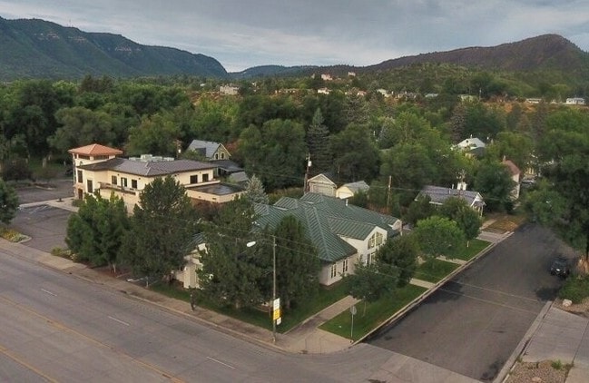
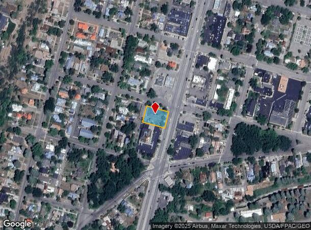

Property Detail
102 W 18Th St
Durango, CO
North Durango
R017607
SUBDIVISION: NORTH DURANGO BLOCK: 24 LOT: 9 THRU:- LOT: 12 N DGO 102 W 18TH ST 102 1/2 W 18TH ST DURANGO 81301
Officebuilding
La Plata
X
Colorado
08067C0492G
9,12
2024
0.32 AC
2025
Downtown Durango
971000
Other Market Areas
15,342 SF
NEARBY LISTINGS FOR SALE OR LEASE
DEMOGRAPHICS near 102 W 18Th St
1 mile
3 mile
5 mile
2024 Total Population
6,687
18,831
24,178
2029 Population
6,862
19,414
24,980
Pop Growth 2024-2029
+ 2.62%
+ 3.10%
+ 3.32%
Average Age
40
39
39
2024 Total Households
2,840
7,885
10,209
HH Growth 2024-2029
+ 2.36%
+ 2.75%
+ 3.01%
Median Household Inc
$74,749
$76,176
$76,138
Avg Household Size
2.20
2.10
2.10
2024 Avg HH Vehicles
2.00
2.00
2.00
Median Home Value
$643,151
$635,652
$616,968
Median Year Built
1965
1980
1986
Nearby Places
Map Layers
Map Styles
 Street
 Aerial
Transit
 Traffic
 Biking
Places
Listings with unknown addresses are not visible on the map
- Restaurants
- Banks
- Shops
- Fitness
- Groceries
PUBLIC TRANSPORTATION
AIRPORT
Durango-La Plata County
Drive
Walk
Distance
Durango-La Plata County
25 min
15.5 mi
Freight Ports
Port of San Diego
Drive
Walk
Distance
Port of San Diego
930 min
799.3 mi
SALE & LEASE HISTORY
LISTING DATE
SALE/LEASE

Sep 24, 2016
For Sale
Jul 26, 2017
For Lease
Nearby Properties
Address
Land Use
TOTAL SIZE
Lot Size
Zoning
Address
Land Use
TOTAL SIZE
Lot Size
Zoning
1,237,361 SF
230.69 AC
Address
Land Use
TOTAL SIZE
Lot Size
Zoning
277,165 SF
16.47 AC
Address
Land Use
TOTAL SIZE
Lot Size
Zoning
174,631 SF
32.10 AC
Address
Land Use
TOTAL SIZE
Lot Size
Zoning
68,857 SF
21.03 AC
Address
Land Use
TOTAL SIZE
Lot Size
Zoning
153,242 SF
11.62 AC
Address
Land Use
TOTAL SIZE
Lot Size
Zoning
30,443 SF
0.65 AC
Address
Land Use
TOTAL SIZE
Lot Size
Zoning
112,681 SF
1.12 AC
Address
Land Use
TOTAL SIZE
Lot Size
Zoning
159,163 SF
5.50 AC
Address
Land Use
TOTAL SIZE
Lot Size
Zoning
87,592 SF
10.30 AC
Address
Land Use
TOTAL SIZE
Lot Size
Zoning
48,369 SF
0.63 AC
Address
Land Use
TOTAL SIZE
Lot Size
Zoning
45,824 SF
4.55 AC
Address
Land Use
TOTAL SIZE
Lot Size
Zoning
78,166 SF
6.73 AC
Address
Land Use
TOTAL SIZE
Lot Size
Zoning
51,923 SF
Address
Land Use
TOTAL SIZE
Lot Size
Zoning
45,340 SF
3.74 AC
Address
Land Use
TOTAL SIZE
Lot Size
Zoning
23,667 SF
1.91 AC
Address
Land Use
TOTAL SIZE
Lot Size
Zoning
51,561 SF
37.58 AC
Address
Land Use
TOTAL SIZE
Lot Size
Zoning
29,546 SF
4.14 AC
Address
Land Use
TOTAL SIZE
Lot Size
Zoning
23,503 SF
14.22 AC
Address
Land Use
TOTAL SIZE
Lot Size
Zoning
112,292 SF
9.21 AC
Address
Land Use
TOTAL SIZE
Lot Size
Zoning
45,481 SF
5 AC
Address
Land Use
TOTAL SIZE
Lot Size
Zoning
72,094 SF
0.57 AC
Address
Land Use
TOTAL SIZE
Lot Size
Zoning
48,258 SF
3.30 AC
Address
Land Use
TOTAL SIZE
Lot Size
Zoning
49,001 SF
7.61 AC
Address
Land Use
TOTAL SIZE
Lot Size
Zoning
52,704 SF
1.73 AC
Address
Land Use
TOTAL SIZE
Lot Size
Zoning
45,080 SF
1.76 AC
Address
Land Use
TOTAL SIZE
Lot Size
Zoning
37,012 SF
2.06 AC
Address
Land Use
TOTAL SIZE
Lot Size
Zoning
62,356 SF
0.46 AC
Address
Land Use
TOTAL SIZE
Lot Size
Zoning
27,219 SF
2.71 AC
Address
Land Use
TOTAL SIZE
Lot Size
Zoning
40,845 SF
1.69 AC
Address
Land Use
TOTAL SIZE
Lot Size
Zoning
39,070 SF
The World's #1 Commercial Real Estate Marketplace
Connect with us
© 2026 CoStar Group
The information above has been obtained from sources believed reliable. While we do not doubt its accuracy we have not verified it and make no guarantee, warranty or representation about it. It is your responsibility to independently confirm its accuracy and completeness. Any projections, opinions, assumptions, or estimates used are for example only and do not represent the current or future performance of the property. The value of this transaction to you depends on tax and other factors which should be evaluated by your tax, financial, and legal advisors. You and your advisors should conduct a careful, independent investigation of the property to determine to your satisfaction the suitability of the property for your needs.