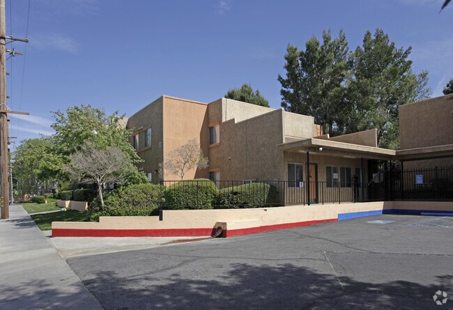
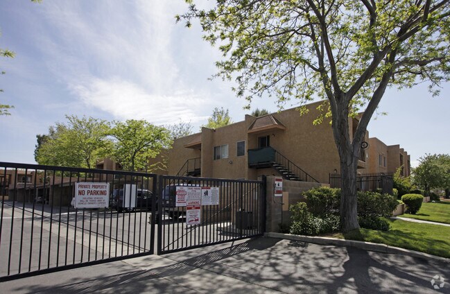
Property Record
1020 E Avenue R, Palmdale, CA 93550

Save to a Folder
{{folder.Name}}
{{folder.ListingIds.length}} Properties
{{folder.ListingIds.length}} Property
Create a New Folder
Property Detail
1020 E Avenue R
3012-001-034
FOR DESC SEE ASSESSORS MAPS*POR NW 1/4 OF NW 1/4 IN SEC 36 T 6N R 12W
Multifamilydwelling
Los Angeles
PDR3
California
C and X Area of minimal flood hazard, usually depicted on FIRMs as above the 500-year flood level.
36
2025
3.38 AC
2025
Outlying LA County
910504
Los Angeles
70,916 SF
Los Angeles-Long Beach-Glendale, CA
NEARBY LISTINGS FOR SALE OR LEASE
DEMOGRAPHICS near 1020 E Avenue R
1 mile
3 mile
5 mile
2025 Total Population
23,396
88,676
145,244
2030 Population
23,328
88,400
144,567
Pop Growth 2025-2030
(0.29%)
(0.31%)
(0.47%)
Average Age
34
36
37
2025 Total Households
7,116
26,109
41,324
HH Growth 2025-2030
(0.34%)
(0.33%)
(0.52%)
Median Household Inc
$51,808
$65,265
$74,919
Avg Household Size
3.30
3.30
3.40
2025 Avg HH Vehicles
2.00
2.00
2.00
Median Home Value
$375,726
$397,331
$436,827
Median Year Built
1982
1984
1987
Nearby Places
Map Layers
Map Styles
 Street
 Aerial
Layers
 Traffic
 Biking
Places
Listings with unknown addresses are not visible on the map
- Restaurants
- Banks
- Shops
- Fitness
- Groceries
PUBLIC TRANSPORTATION
COMMUTER RAIL
Palmdale (Antelope Valley Line - Southern California Regional Rail Authority (Metrolink))
Drive
Walk
Distance
Palmdale (Antelope Valley Line - Southern California Regional Rail Authority (Metrolink))
3 min
1.6 mi
Vincent Grade/Acton (Antelope Valley Line - Southern California Regional Rail Authority (Metrolink))
Drive
Walk
Distance
Vincent Grade/Acton (Antelope Valley Line - Southern California Regional Rail Authority (Metrolink))
11 min
6.3 mi
AIRPORT
Bob Hope
Drive
Walk
Distance
Bob Hope
58 min
49.1 mi
Nearby Properties
Address
Land Use
TOTAL SIZE
Lot Size
Zoning
Address
Land Use
TOTAL SIZE
Lot Size
Zoning
2,861,890 SF
528.69 AC
POMA-A25*
Address
Land Use
TOTAL SIZE
Lot Size
Zoning
358,828 SF
26.23 AC
PDR17000
Address
Land Use
TOTAL SIZE
Lot Size
Zoning
130,392 SF
26.91 AC
PDCPD*
Address
Land Use
TOTAL SIZE
Lot Size
Zoning
167,366 SF
15.36 AC
PDC3
Address
Land Use
TOTAL SIZE
Lot Size
Zoning
88,750 SF
9.28 AC
PDM1 1/2*
Address
Land Use
TOTAL SIZE
Lot Size
Zoning
128,353 SF
9.49 AC
PDCPD-R1*
Address
Land Use
TOTAL SIZE
Lot Size
Zoning
50,735 SF
PDCPD
Address
Land Use
TOTAL SIZE
Lot Size
Zoning
78,492 SF
3.25 AC
PDCPD
Address
Land Use
TOTAL SIZE
Lot Size
Zoning
139,513 SF
4.07 AC
PDCPD
Address
Land Use
TOTAL SIZE
Lot Size
Zoning
60,644 SF
3.89 AC
PDMX*
Address
Land Use
TOTAL SIZE
Lot Size
Zoning
103,503 SF
3.61 AC
PDC2
Address
Land Use
TOTAL SIZE
Lot Size
Zoning
64,818 SF
2.30 AC
PDCP
Address
Land Use
TOTAL SIZE
Lot Size
Zoning
221,827 SF
14.90 AC
PDRPD10U-R
Address
Land Use
TOTAL SIZE
Lot Size
Zoning
157,021 SF
PDRN4
Address
Land Use
TOTAL SIZE
Lot Size
Zoning
59,577 SF
0.59 AC
PDR17000
Address
Land Use
TOTAL SIZE
Lot Size
Zoning
209,328 SF
6.35 AC
PDC3-RPD15
Address
Land Use
TOTAL SIZE
Lot Size
Zoning
69,555 SF
7.55 AC
PDMPD*
Address
Land Use
TOTAL SIZE
Lot Size
Zoning
71,394 SF
2.93 AC
PDCPD*
Address
Land Use
TOTAL SIZE
Lot Size
Zoning
76,609 SF
3.61 AC
PDM2
Address
Land Use
TOTAL SIZE
Lot Size
Zoning
36,033 SF
3.81 AC
PDMPD*
Address
Land Use
TOTAL SIZE
Lot Size
Zoning
144,471 SF
12.96 AC
PDCPD-MPD*
Address
Land Use
TOTAL SIZE
Lot Size
Zoning
80,981 SF
7.11 AC
PDC3
Address
Land Use
TOTAL SIZE
Lot Size
Zoning
55,079 SF
1.98 AC
PDCPD*
Address
Land Use
TOTAL SIZE
Lot Size
Zoning
71,974 SF
3.83 AC
PDCPD*
Address
Land Use
TOTAL SIZE
Lot Size
Zoning
377,382 SF
8.99 AC
PDMP
Address
Land Use
TOTAL SIZE
Lot Size
Zoning
207,582 SF
18.74 AC
PDR1*
Address
Land Use
TOTAL SIZE
Lot Size
Zoning
61,883 SF
4.10 AC
PDMPD*
Address
Land Use
TOTAL SIZE
Lot Size
Zoning
133,410 SF
12.66 AC
PDMPD*
Address
Land Use
TOTAL SIZE
Lot Size
Zoning
115,800 SF
11.51 AC
PDCPD-MPD*
Address
Land Use
TOTAL SIZE
Lot Size
Zoning
47,224 SF
2.10 AC
PDCPD*
The World's #1 Commercial Real Estate Marketplace
Connect with us
© 2026 CoStar Group
The information above has been obtained from sources believed reliable. While we do not doubt its accuracy we have not verified it and make no guarantee, warranty or representation about it. It is your responsibility to independently confirm its accuracy and completeness. Any projections, opinions, assumptions, or estimates used are for example only and do not represent the current or future performance of the property. The value of this transaction to you depends on tax and other factors which should be evaluated by your tax, financial, and legal advisors. You and your advisors should conduct a careful, independent investigation of the property to determine to your satisfaction the suitability of the property for your needs.