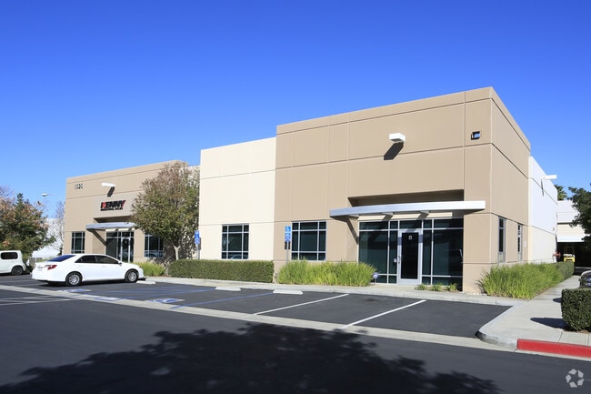
Property Record
1020 Northgate St, Riverside, CA 92507
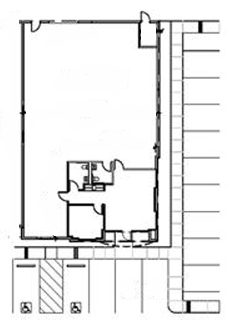
Current Lease Availabilities
Property Detail
1020 Northgate St
Riverside-San Bernardino-Ontario, CA
UNIT C2 BLK C CM 192/091 INT COMM IN LOT 1 PM 33469 PM 219/100
257-021-008
Riverside
Lightindustrial
California
B and X Area of moderate flood hazard, usually the area between the limits of the 100-year and 500-year floods.
1
2024
0.08 AC
2025
Riverside
042209
Inland Empire (California)
3,424 SF
NEARBY LISTINGS FOR SALE OR LEASE
DEMOGRAPHICS near 1020 Northgate St
1 mile
3 mile
5 mile
2025 Total Population
4,546
82,203
201,526
2030 Population
4,761
84,233
206,044
Pop Growth 2025-2030
+ 4.73%
+ 2.47%
+ 2.24%
Average Age
35
34
36
2025 Total Households
1,264
24,298
63,005
HH Growth 2025-2030
+ 4.35%
+ 2.05%
+ 1.98%
Median Household Inc
$113,341
$79,672
$82,009
Avg Household Size
3.50
2.90
3.00
2025 Avg HH Vehicles
3.00
2.00
2.00
Median Home Value
$667,508
$527,348
$585,812
Median Year Built
1989
1977
1978
Nearby Places
Map Layers
Map Styles
 Street
 Aerial
Layers
 Traffic
 Biking
Places
Listings with unknown addresses are not visible on the map
- Restaurants
- Banks
- Shops
- Fitness
- Groceries
PUBLIC TRANSPORTATION
COMMUTER RAIL
Riverside-Hunter Park/Ucr (Metrolink 91-Perris Valley Line - Metrolink Trains)
Drive
Walk
Distance
Riverside-Hunter Park/Ucr (Metrolink 91-Perris Valley Line - Metrolink Trains)
3 min
16 min
0.9 mi
Riverside-Downtown (91 Line - Southern California Regional Rail Authority (Metrolink), Inland Empire-Orange County Line - Southern California Regional Rail Authority (Metrolink), Riverside Line - Southern California Regional Rail Authority (Metrolink))
Drive
Walk
Distance
Riverside-Downtown (91 Line - Southern California Regional Rail Authority (Metrolink), Inland Empire-Orange County Line - Southern California Regional Rail Authority (Metrolink), Riverside Line - Southern California Regional Rail Authority (Metrolink))
9 min
4.3 mi
AIRPORT
Ontario International
Drive
Walk
Distance
Ontario International
27 min
19.2 mi
Freight Ports
Port of Long Beach
Drive
Walk
Distance
Port of Long Beach
77 min
60.0 mi
Nearby Properties
Address
Land Use
TOTAL SIZE
Lot Size
Zoning
Address
Land Use
TOTAL SIZE
Lot Size
Zoning
798,304 SF
42.64 AC
AMSP
Address
Land Use
TOTAL SIZE
Lot Size
Zoning
1,009,120 SF
35.22 AC
Address
Land Use
TOTAL SIZE
Lot Size
Zoning
494,575 SF
25.33 AC
MP
Address
Land Use
TOTAL SIZE
Lot Size
Zoning
599,735 SF
33.25 AC
AMSP
Address
Land Use
TOTAL SIZE
Lot Size
Zoning
369,842 SF
16.35 AC
Address
Land Use
TOTAL SIZE
Lot Size
Zoning
411,707 SF
19.34 AC
Address
Land Use
TOTAL SIZE
Lot Size
Zoning
350,278 SF
1.21 AC
Address
Land Use
TOTAL SIZE
Lot Size
Zoning
447,190 SF
21.08 AC
Address
Land Use
TOTAL SIZE
Lot Size
Zoning
26,879 SF
16.27 AC
R3
Address
Land Use
TOTAL SIZE
Lot Size
Zoning
217,036 SF
1.66 AC
C2
Address
Land Use
TOTAL SIZE
Lot Size
Zoning
182,624 SF
16.07 AC
Address
Land Use
TOTAL SIZE
Lot Size
Zoning
245,476 SF
15.61 AC
Address
Land Use
TOTAL SIZE
Lot Size
Zoning
156,241 SF
2.55 AC
Address
Land Use
TOTAL SIZE
Lot Size
Zoning
55.22 AC
AMSP
Address
Land Use
TOTAL SIZE
Lot Size
Zoning
139,454 SF
0.97 AC
DSP
Address
Land Use
TOTAL SIZE
Lot Size
Zoning
36,010 SF
11.76 AC
R3
Address
Land Use
TOTAL SIZE
Lot Size
Zoning
182,446 SF
9.01 AC
Address
Land Use
TOTAL SIZE
Lot Size
Zoning
134,944 SF
2.52 AC
Address
Land Use
TOTAL SIZE
Lot Size
Zoning
415,990 SF
5.16 AC
Address
Land Use
TOTAL SIZE
Lot Size
Zoning
307,163 SF
16.65 AC
Address
Land Use
TOTAL SIZE
Lot Size
Zoning
230,063 SF
11.06 AC
Address
Land Use
TOTAL SIZE
Lot Size
Zoning
304,560 SF
16.79 AC
IP
Address
Land Use
TOTAL SIZE
Lot Size
Zoning
122,738 SF
10.77 AC
Address
Land Use
TOTAL SIZE
Lot Size
Zoning
69,660 SF
0.62 AC
C3
Address
Land Use
TOTAL SIZE
Lot Size
Zoning
Address
Land Use
TOTAL SIZE
Lot Size
Zoning
156,998 SF
11.90 AC
MP
Address
Land Use
TOTAL SIZE
Lot Size
Zoning
8.81 AC
R3S3
The World's #1 Commercial Real Estate Marketplace
Connect with us
© 2026 CoStar Group
The information above has been obtained from sources believed reliable. While we do not doubt its accuracy we have not verified it and make no guarantee, warranty or representation about it. It is your responsibility to independently confirm its accuracy and completeness. Any projections, opinions, assumptions, or estimates used are for example only and do not represent the current or future performance of the property. The value of this transaction to you depends on tax and other factors which should be evaluated by your tax, financial, and legal advisors. You and your advisors should conduct a careful, independent investigation of the property to determine to your satisfaction the suitability of the property for your needs.