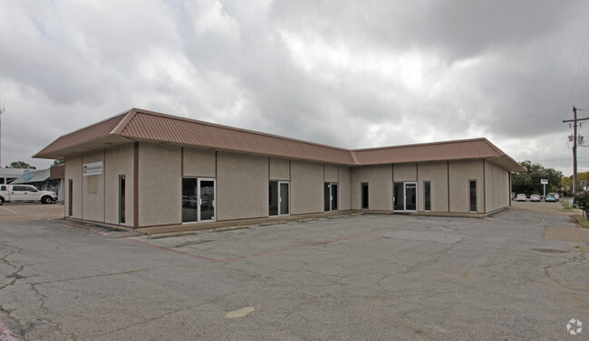
Property Record
1020 W Main St, Arlington, TX 76013

Property Detail
1020 W Main St
Dallas-Fort Worth-Arlington, TX
ARLINGTON HEIGHTS ADDITION BLOCK 1 LOT 10R
00068683
TARRANT
Commercialnec
Texas
B and X Area of moderate flood hazard, usually the area between the limits of the 100-year and 500-year floods.
10r
2025
0.32 AC
2025
Arlington/Mansfield
122300
Dallas/Ft Worth
4,799 SF
NEARBY LISTINGS FOR SALE OR LEASE
DEMOGRAPHICS near 1020 W Main St
1 mile
3 mile
5 mile
2025 Total Population
20,219
138,305
296,067
2030 Population
21,437
145,733
311,476
Pop Growth 2025-2030
+ 6.02%
+ 5.37%
+ 5.20%
Average Age
32
36
36
2025 Total Households
6,800
52,341
113,942
HH Growth 2025-2030
+ 6.44%
+ 5.60%
+ 5.40%
Median Household Inc
$42,806
$60,911
$63,300
Avg Household Size
2.30
2.50
2.50
2025 Avg HH Vehicles
2.00
2.00
2.00
Median Home Value
$278,665
$281,070
$294,322
Median Year Built
1980
1976
1981
Nearby Places
Map Layers
Map Styles
 Street
 Aerial
Layers
 Traffic
 Biking
Places
Listings with unknown addresses are not visible on the map
- Restaurants
- Banks
- Shops
- Fitness
- Groceries
PUBLIC TRANSPORTATION
COMMUTER RAIL
Drive
Walk
Distance
18 min
7.0 mi
AIRPORT
Dallas-Fort Worth International
Drive
Walk
Distance
Dallas-Fort Worth International
28 min
16.4 mi
Dallas Love Field
Drive
Walk
Distance
Dallas Love Field
38 min
24.6 mi
SALE & LEASE HISTORY
LISTING DATE
SALE/LEASE

Oct 18, 2019
For Lease
May 28, 2021
For Lease
Nearby Properties
Address
Land Use
TOTAL SIZE
Lot Size
Zoning
Address
Land Use
TOTAL SIZE
Lot Size
Zoning
1,700,000 SF
8.23 AC
Address
Land Use
TOTAL SIZE
Lot Size
Zoning
3,015,800 SF
72.86 AC
Address
Land Use
TOTAL SIZE
Lot Size
Zoning
1,400,000 SF
15.30 AC
Address
Land Use
TOTAL SIZE
Lot Size
Zoning
640,583 SF
Address
Land Use
TOTAL SIZE
Lot Size
Zoning
269,257 SF
21.33 AC
Address
Land Use
TOTAL SIZE
Lot Size
Zoning
378,182 SF
5.02 AC
Address
Land Use
TOTAL SIZE
Lot Size
Zoning
287,560 SF
3.28 AC
Address
Land Use
TOTAL SIZE
Lot Size
Zoning
1,129,022 SF
16.84 AC
Address
Land Use
TOTAL SIZE
Lot Size
Zoning
320,636 SF
12.71 AC
Address
Land Use
TOTAL SIZE
Lot Size
Zoning
595,207 SF
7.20 AC
Address
Land Use
TOTAL SIZE
Lot Size
Zoning
492,970 SF
44.82 AC
Address
Land Use
TOTAL SIZE
Lot Size
Zoning
458,819 SF
15.88 AC
Address
Land Use
TOTAL SIZE
Lot Size
Zoning
462,207 SF
2.82 AC
Address
Land Use
TOTAL SIZE
Lot Size
Zoning
578,395 SF
6.22 AC
Address
Land Use
TOTAL SIZE
Lot Size
Zoning
422,300 SF
2.50 AC
Address
Land Use
TOTAL SIZE
Lot Size
Zoning
347,421 SF
4.47 AC
Address
Land Use
TOTAL SIZE
Lot Size
Zoning
548,806 SF
5.56 AC
Address
Land Use
TOTAL SIZE
Lot Size
Zoning
377,463 SF
19.50 AC
Address
Land Use
TOTAL SIZE
Lot Size
Zoning
139,821 SF
Address
Land Use
TOTAL SIZE
Lot Size
Zoning
492,837 SF
4.99 AC
Address
Land Use
TOTAL SIZE
Lot Size
Zoning
389,946 SF
2.35 AC
Address
Land Use
TOTAL SIZE
Lot Size
Zoning
539,000 SF
3.91 AC
Address
Land Use
TOTAL SIZE
Lot Size
Zoning
313,349 SF
15.39 AC
Address
Land Use
TOTAL SIZE
Lot Size
Zoning
296,092 SF
7.66 AC
Address
Land Use
TOTAL SIZE
Lot Size
Zoning
327,309 SF
3.45 AC
Address
Land Use
TOTAL SIZE
Lot Size
Zoning
720,000 SF
9.80 AC
Address
Land Use
TOTAL SIZE
Lot Size
Zoning
162,537 SF
19.70 AC
Address
Land Use
TOTAL SIZE
Lot Size
Zoning
555,428 SF
14.57 AC
Address
Land Use
TOTAL SIZE
Lot Size
Zoning
218,000 SF
3.98 AC
Address
Land Use
TOTAL SIZE
Lot Size
Zoning
386,575 SF
42.27 AC
The World's #1 Commercial Real Estate Marketplace
Connect with us
© 2026 CoStar Group
The information above has been obtained from sources believed reliable. While we do not doubt its accuracy we have not verified it and make no guarantee, warranty or representation about it. It is your responsibility to independently confirm its accuracy and completeness. Any projections, opinions, assumptions, or estimates used are for example only and do not represent the current or future performance of the property. The value of this transaction to you depends on tax and other factors which should be evaluated by your tax, financial, and legal advisors. You and your advisors should conduct a careful, independent investigation of the property to determine to your satisfaction the suitability of the property for your needs.