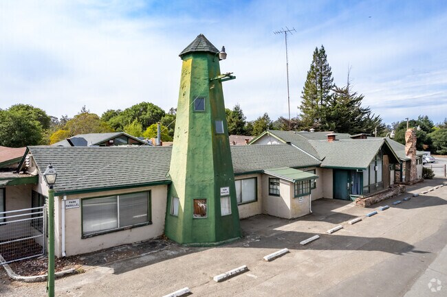
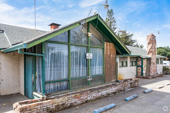
Property Record
10201 Old Redwood Hwy, Penngrove, CA 94951


NEARBY LISTINGS FOR SALE OR LEASE
Property Detail
10201 Old Redwood Hwy
Santa Rosa-Petaluma, CA
Wharfs Sub
047-052-001
BUSINESS CODE: BA UNINCORP COUNTY CA
Publicschool
Sonoma
X
California
06097C0891F
14
2024
9.68 AC
2025
Petaluma/Cotati/Rohnert
151205
North Bay/Santa Rosa
13,386 SF
DEMOGRAPHICS near 10201 Old Redwood Hwy
1 Mile
3 Mile
5 Mile
2024 Total Population
1,332
35,272
91,428
2029 Population
1,242
34,721
90,365
Pop Growth 2024-2029
(6.76%)
(1.56%)
(1.16%)
Average Age
47
40
41
2024 Total Households
564
13,224
35,356
HH Growth 2024-2029
(6.74%)
(1.68%)
(1.22%)
Median Household Inc
$94,422
$95,419
$95,972
Avg Household Size
2.20
2.60
2.50
2024 Avg HH Vehicles
2.00
2.00
2.00
Median Home Value
$929,011
$738,095
$741,203
Median Year Built
1967
1981
1982
Nearby Places
Map Layers
Map Styles
 Street
 Aerial
- Restaurants
- Banks
- Shops
- Fitness
- Groceries
PUBLIC TRANSPORTATION
COMMUTER RAIL
DRIVE
WALK
Distance
6 min
3.1 mi
DRIVE
WALK
Distance
7 min
3.5 mi
AIRPORT
Charles M Schulz - Sonoma County
DRIVE
WALK
Distance
Charles M Schulz - Sonoma County
24 min
17.9 mi
Freight Ports
Port of Richmond
DRIVE
WALK
Distance
Port of Richmond
52 min
38.5 mi
Nearby Properties
Address
Land Use
TOTAL SIZE
Lot Size
Zoning
Address
Land Use
TOTAL SIZE
Lot Size
Zoning
589,133 SF
36.26 AC
Address
Land Use
TOTAL SIZE
Lot Size
Zoning
229,265 SF
3.03 AC
RM
Address
Land Use
TOTAL SIZE
Lot Size
Zoning
1.18 AC
Address
Land Use
TOTAL SIZE
Lot Size
Zoning
138,520 SF
10.36 AC
ML
Address
Land Use
TOTAL SIZE
Lot Size
Zoning
50,880 SF
4.77 AC
CITYRP
Address
Land Use
TOTAL SIZE
Lot Size
Zoning
138,134 SF
12.54 AC
C1
Address
Land Use
TOTAL SIZE
Lot Size
Zoning
88,482 SF
7.29 AC
Address
Land Use
TOTAL SIZE
Lot Size
Zoning
5,830 SF
5.50 AC
CITYRP
Address
Land Use
TOTAL SIZE
Lot Size
Zoning
4.19 AC
CITYRP
Address
Land Use
TOTAL SIZE
Lot Size
Zoning
16,392 SF
6.67 AC
RM
Address
Land Use
TOTAL SIZE
Lot Size
Zoning
81,682 SF
2.59 AC
CITYPE
Address
Land Use
TOTAL SIZE
Lot Size
Zoning
71,884 SF
0.65 AC
Address
Land Use
TOTAL SIZE
Lot Size
Zoning
141,168 SF
9.44 AC
18
Address
Land Use
TOTAL SIZE
Lot Size
Zoning
54,637 SF
0.66 AC
Address
Land Use
TOTAL SIZE
Lot Size
Zoning
90,530 SF
2.61 AC
Address
Land Use
TOTAL SIZE
Lot Size
Zoning
58,299 SF
0.72 AC
Address
Land Use
TOTAL SIZE
Lot Size
Zoning
6.16 AC
RM
Address
Land Use
TOTAL SIZE
Lot Size
Zoning
44,244 SF
3.44 AC
Address
Land Use
TOTAL SIZE
Lot Size
Zoning
6,882 SF
6.56 AC
CITYPE
Address
Land Use
TOTAL SIZE
Lot Size
Zoning
Address
Land Use
TOTAL SIZE
Lot Size
Zoning
181,292 SF
66.88 AC
LEA60
Address
Land Use
TOTAL SIZE
Lot Size
Zoning
51,264 SF
1.53 AC
CITYRP
Address
Land Use
TOTAL SIZE
Lot Size
Zoning
42,388 SF
1.11 AC
CITYPE
Address
Land Use
TOTAL SIZE
Lot Size
Zoning
57,340 SF
3.82 AC
CITYPE
Address
Land Use
TOTAL SIZE
Lot Size
Zoning
21,000 SF
2.24 AC
Address
Land Use
TOTAL SIZE
Lot Size
Zoning
17,015 SF
1 AC
CITYPE
Address
Land Use
TOTAL SIZE
Lot Size
Zoning
77,576 SF
3.41 AC
MR
Address
Land Use
TOTAL SIZE
Lot Size
Zoning
132,340 SF
6.86 AC
CITYPE
Address
Land Use
TOTAL SIZE
Lot Size
Zoning
28,528 SF
0.60 AC
Address
Land Use
TOTAL SIZE
Lot Size
Zoning
28.38 AC
The World's #1 Commercial Real Estate Marketplace
Connect with us
© 2026 CoStar Group
The information above has been obtained from sources believed reliable. While we do not doubt its accuracy we have not verified it and make no guarantee, warranty or representation about it. It is your responsibility to independently confirm its accuracy and completeness. Any projections, opinions, assumptions, or estimates used are for example only and do not represent the current or future performance of the property. The value of this transaction to you depends on tax and other factors which should be evaluated by your tax, financial, and legal advisors. You and your advisors should conduct a careful, independent investigation of the property to determine to your satisfaction the suitability of the property for your needs.