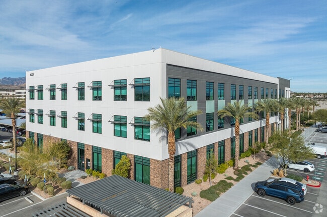
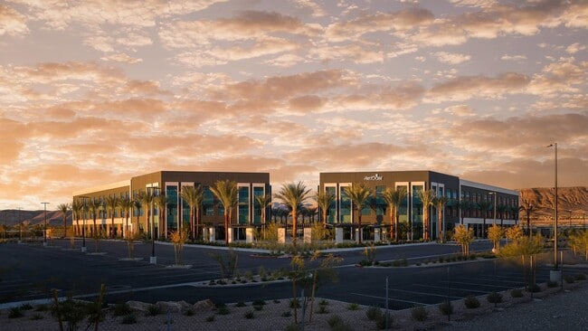
Property Record
10220 Aristocrat Way, Las Vegas, NV 89135

NEARBY LISTINGS FOR SALE OR LEASE
Property Detail
10220 Aristocrat Way
Las Vegas-Henderson-North Las Vegas, NV
Summerlin Village 15A Parcel 4 Phase 2
164-13-810-005
SUMMERLIN VILLAGE 15A PARCEL 4 PHASE 2 PLAT BOOK 105 PAGE 35 PT LOT 3 & VAC RD
Commercialnec
Clark
X
Nevada
32003C2550F
3
2025
12.49 AC
2025
Southwest Las Vegas
005846
Las Vegas
184,152 SF
DEMOGRAPHICS near 10220 Aristocrat Way
1 Mile
3 Mile
5 Mile
2024 Total Population
16,671
138,291
306,014
2029 Population
17,982
148,640
330,104
Pop Growth 2024-2029
+ 7.86%
+ 7.48%
+ 7.87%
Average Age
45
42
41
2024 Total Households
7,247
57,259
122,687
HH Growth 2024-2029
+ 7.99%
+ 7.46%
+ 7.81%
Median Household Inc
$74,340
$74,092
$74,403
Avg Household Size
2.30
2.40
2.50
2024 Avg HH Vehicles
2.00
2.00
2.00
Median Home Value
$459,177
$443,458
$428,439
Median Year Built
2003
1999
1999
Nearby Places
Map Layers
Map Styles
 Street
 Aerial
- Restaurants
- Banks
- Shops
- Fitness
- Groceries
PUBLIC TRANSPORTATION
AIRPORT
Harry Reid International
DRIVE
WALK
Distance
Harry Reid International
21 min
14.7 mi
Boulder City Municipal
DRIVE
WALK
Distance
Boulder City Municipal
46 min
34.3 mi
Freight Ports
Port of Long Beach
DRIVE
WALK
Distance
Port of Long Beach
323 min
286.3 mi
Nearby Properties
Address
Land Use
TOTAL SIZE
Lot Size
Zoning
Address
Land Use
TOTAL SIZE
Lot Size
Zoning
421,874 SF
59.43 AC
H1
Address
Land Use
TOTAL SIZE
Lot Size
Zoning
29,374 SF
7.06 AC
Address
Land Use
TOTAL SIZE
Lot Size
Zoning
174,108 SF
52.16 AC
RU
Address
Land Use
TOTAL SIZE
Lot Size
Zoning
466,224 SF
11.85 AC
C:C-2
Address
Land Use
TOTAL SIZE
Lot Size
Zoning
9,279 SF
24.36 AC
Address
Land Use
TOTAL SIZE
Lot Size
Zoning
38.56 AC
PF
Address
Land Use
TOTAL SIZE
Lot Size
Zoning
504,632 SF
6.25 AC
Address
Land Use
TOTAL SIZE
Lot Size
Zoning
4,542 SF
18.72 AC
Address
Land Use
TOTAL SIZE
Lot Size
Zoning
Address
Land Use
TOTAL SIZE
Lot Size
Zoning
52,690 SF
17.65 AC
RU
Address
Land Use
TOTAL SIZE
Lot Size
Zoning
280,968 SF
1.45 AC
Address
Land Use
TOTAL SIZE
Lot Size
Zoning
Address
Land Use
TOTAL SIZE
Lot Size
Zoning
41,331 SF
1.59 AC
Address
Land Use
TOTAL SIZE
Lot Size
Zoning
Address
Land Use
TOTAL SIZE
Lot Size
Zoning
Address
Land Use
TOTAL SIZE
Lot Size
Zoning
33.24 AC
C1
Address
Land Use
TOTAL SIZE
Lot Size
Zoning
3,520 SF
28.42 AC
R3
Address
Land Use
TOTAL SIZE
Lot Size
Zoning
6,825 SF
9.11 AC
Address
Land Use
TOTAL SIZE
Lot Size
Zoning
4,446 SF
16.17 AC
Address
Land Use
TOTAL SIZE
Lot Size
Zoning
5,374 SF
12.36 AC
Address
Land Use
TOTAL SIZE
Lot Size
Zoning
43,264 SF
3.56 AC
Address
Land Use
TOTAL SIZE
Lot Size
Zoning
322,127 SF
9.32 AC
Address
Land Use
TOTAL SIZE
Lot Size
Zoning
5,427 SF
17.57 AC
Address
Land Use
TOTAL SIZE
Lot Size
Zoning
485,241 SF
13.77 AC
R3
Address
Land Use
TOTAL SIZE
Lot Size
Zoning
259,832 SF
3.79 AC
Address
Land Use
TOTAL SIZE
Lot Size
Zoning
11,942 SF
17.01 AC
R3
Address
Land Use
TOTAL SIZE
Lot Size
Zoning
21.17 AC
PF
Address
Land Use
TOTAL SIZE
Lot Size
Zoning
310,672 SF
8.84 AC
Address
Land Use
TOTAL SIZE
Lot Size
Zoning
220,053 SF
3.04 AC
Address
Land Use
TOTAL SIZE
Lot Size
Zoning
2,754 SF
17.17 AC
RPD20
The World's #1 Commercial Real Estate Marketplace
Connect with us
© 2026 CoStar Group
The information above has been obtained from sources believed reliable. While we do not doubt its accuracy we have not verified it and make no guarantee, warranty or representation about it. It is your responsibility to independently confirm its accuracy and completeness. Any projections, opinions, assumptions, or estimates used are for example only and do not represent the current or future performance of the property. The value of this transaction to you depends on tax and other factors which should be evaluated by your tax, financial, and legal advisors. You and your advisors should conduct a careful, independent investigation of the property to determine to your satisfaction the suitability of the property for your needs.