Property Record
1025 Bypass Rd, Winchester, KY 40391
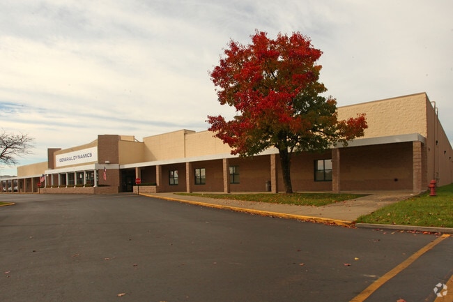

Property Detail
1025 Bypass Rd
042-0000-04200
PARCEL 6A-2 PLAT 99B
Commercialnec
Clark
PLANNED DE
Kentucky
AE The base floodplain where base flood elevations are provided. AE Zones are now used on new format FIRMs instead of A1-A30 Zones.
8.82 AC
2025
Clark County
2025
Lexington/Fayette
020600
Lexington-Fayette, KY
69,834 SF
NEARBY LISTINGS FOR SALE OR LEASE
-
-
View all Winchester listings for sale on LoopNet.com
DEMOGRAPHICS near 1025 Bypass Rd
1 mile
3 mile
5 mile
2025 Total Population
7,008
25,326
30,794
2030 Population
7,201
25,953
31,520
Pop Growth 2025-2030
+ 2.75%
+ 2.48%
+ 2.36%
Average Age
39
41
41
2025 Total Households
2,975
10,411
12,566
HH Growth 2025-2030
+ 2.76%
+ 2.50%
+ 2.39%
Median Household Inc
$65,730
$64,920
$65,326
Avg Household Size
2.30
2.40
2.40
2025 Avg HH Vehicles
2.00
2.00
2.00
Median Home Value
$208,266
$213,366
$205,124
Median Year Built
1989
1980
1981
Nearby Places
Map Layers
Map Styles
 Street
 Aerial
Layers
 Traffic
 Biking
Places
Listings with unknown addresses are not visible on the map
- Restaurants
- Banks
- Shops
- Fitness
- Groceries
PUBLIC TRANSPORTATION
AIRPORT
Blue Grass
Drive
Walk
Distance
Blue Grass
40 min
27.9 mi
Nearby Properties
Address
Land Use
TOTAL SIZE
Lot Size
Zoning
Address
Land Use
TOTAL SIZE
Lot Size
Zoning
45,000 SF
30.26 AC
AGRICULTUR
Address
Land Use
TOTAL SIZE
Lot Size
Zoning
423,158 SF
36.32 AC
LIGHT INDU
Address
Land Use
TOTAL SIZE
Lot Size
Zoning
127.39 AC
Address
Land Use
TOTAL SIZE
Lot Size
Zoning
Address
Land Use
TOTAL SIZE
Lot Size
Zoning
792 SF
5.71 AC
SINGLE FAM
Address
Land Use
TOTAL SIZE
Lot Size
Zoning
Address
Land Use
TOTAL SIZE
Lot Size
Zoning
Address
Land Use
TOTAL SIZE
Lot Size
Zoning
Address
Land Use
TOTAL SIZE
Lot Size
Zoning
Address
Land Use
TOTAL SIZE
Lot Size
Zoning
179,856 SF
20.42 AC
PLANNED DE
Address
Land Use
TOTAL SIZE
Lot Size
Zoning
60,726 SF
14.59 AC
Address
Land Use
TOTAL SIZE
Lot Size
Zoning
136,116 SF
12.58 AC
LIGHT INDU
Address
Land Use
TOTAL SIZE
Lot Size
Zoning
Address
Land Use
TOTAL SIZE
Lot Size
Zoning
698,666 SF
44.85 AC
LIGHT INDU
Address
Land Use
TOTAL SIZE
Lot Size
Zoning
6.65 AC
I1
Address
Land Use
TOTAL SIZE
Lot Size
Zoning
6.50 AC
PD
Address
Land Use
TOTAL SIZE
Lot Size
Zoning
0.98 AC
DOWNTOWN B
Address
Land Use
TOTAL SIZE
Lot Size
Zoning
17.86 AC
I1
Address
Land Use
TOTAL SIZE
Lot Size
Zoning
24.23 AC
I1
Address
Land Use
TOTAL SIZE
Lot Size
Zoning
121,809 SF
19.44 AC
LIGHT INDU
Address
Land Use
TOTAL SIZE
Lot Size
Zoning
Address
Land Use
TOTAL SIZE
Lot Size
Zoning
76,440 SF
15.67 AC
PLANNED DE
Address
Land Use
TOTAL SIZE
Lot Size
Zoning
4.53 AC
Address
Land Use
TOTAL SIZE
Lot Size
Zoning
64,000 SF
8.45 AC
HIGHWAY BU
Address
Land Use
TOTAL SIZE
Lot Size
Zoning
3.15 AC
Address
Land Use
TOTAL SIZE
Lot Size
Zoning
60,060 SF
6.04 AC
HIGHWAY BU
Address
Land Use
TOTAL SIZE
Lot Size
Zoning
15.06 AC
I1
Address
Land Use
TOTAL SIZE
Lot Size
Zoning
3.59 AC
I1
Address
Land Use
TOTAL SIZE
Lot Size
Zoning
Address
Land Use
TOTAL SIZE
Lot Size
Zoning
5.79 AC
I1
The World's #1 Commercial Real Estate Marketplace
Connect with us
© 2026 CoStar Group
The information above has been obtained from sources believed reliable. While we do not doubt its accuracy we have not verified it and make no guarantee, warranty or representation about it. It is your responsibility to independently confirm its accuracy and completeness. Any projections, opinions, assumptions, or estimates used are for example only and do not represent the current or future performance of the property. The value of this transaction to you depends on tax and other factors which should be evaluated by your tax, financial, and legal advisors. You and your advisors should conduct a careful, independent investigation of the property to determine to your satisfaction the suitability of the property for your needs.