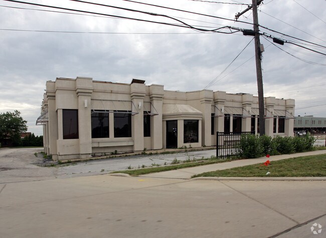
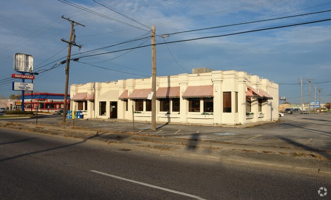
Property Record
10259 S Harlem Ave, Chicago Ridge, IL 60415
NEARBY LISTINGS FOR SALE OR LEASE
Property Detail
10259 S Harlem Ave
24-07-307-015-0000
Earl J Clapps Sub
Commercialbuilding
Cook
X
Illinois
17031C0608J
1
2023
0.59 AC
2025
Near South Cook
823001
Chicago
2,405 SF
Chicago-Naperville-Elgin, IL-IN-WI
DEMOGRAPHICS near 10259 S Harlem Ave
1 Mile
3 Mile
5 Mile
2024 Total Population
15,688
129,135
284,393
2029 Population
15,257
125,351
276,433
Pop Growth 2024-2029
(2.75%)
(2.93%)
(2.80%)
Average Age
40
41
41
2024 Total Households
6,210
47,440
105,374
HH Growth 2024-2029
(3.08%)
(3.23%)
(3.07%)
Median Household Inc
$52,611
$67,718
$71,888
Avg Household Size
2.40
2.60
2.60
2024 Avg HH Vehicles
2.00
2.00
2.00
Median Home Value
$195,069
$244,161
$244,547
Median Year Built
1973
1971
1969
Nearby Places
Map Layers
Map Styles
 Street
 Aerial
- Restaurants
- Banks
- Shops
- Fitness
- Groceries
PUBLIC TRANSPORTATION
COMMUTER RAIL
Worth Station (SouthWest Service - Northeast Illinois Regional Commuter Railroad (Metra))
DRIVE
WALK
Distance
Worth Station (SouthWest Service - Northeast Illinois Regional Commuter Railroad (Metra))
4 min
1.3 mi
Chicago Ridge Station (SouthWest Service - Northeast Illinois Regional Commuter Railroad (Metra))
DRIVE
WALK
Distance
Chicago Ridge Station (SouthWest Service - Northeast Illinois Regional Commuter Railroad (Metra))
5 min
2.2 mi
AIRPORT
Chicago Midway International
DRIVE
WALK
Distance
Chicago Midway International
14 min
7.9 mi
Chicago O'Hare International
DRIVE
WALK
Distance
Chicago O'Hare International
55 min
26.9 mi
Nearby Properties
Address
Land Use
TOTAL SIZE
Lot Size
Zoning
Address
Land Use
TOTAL SIZE
Lot Size
Zoning
13.59 AC
MU
Address
Land Use
TOTAL SIZE
Lot Size
Zoning
Address
Land Use
TOTAL SIZE
Lot Size
Zoning
23.81 AC
Address
Land Use
TOTAL SIZE
Lot Size
Zoning
51,762 SF
4 AC
Address
Land Use
TOTAL SIZE
Lot Size
Zoning
111,830 SF
2.16 AC
Address
Land Use
TOTAL SIZE
Lot Size
Zoning
252,973 SF
11.68 AC
Address
Land Use
TOTAL SIZE
Lot Size
Zoning
191,763 SF
15.63 AC
Address
Land Use
TOTAL SIZE
Lot Size
Zoning
198,190 SF
15 AC
Address
Land Use
TOTAL SIZE
Lot Size
Zoning
401,021 SF
27.42 AC
Address
Land Use
TOTAL SIZE
Lot Size
Zoning
61,388 SF
2 AC
Address
Land Use
TOTAL SIZE
Lot Size
Zoning
1.16 AC
Address
Land Use
TOTAL SIZE
Lot Size
Zoning
510,332 SF
23.97 AC
Address
Land Use
TOTAL SIZE
Lot Size
Zoning
45,196 SF
1.28 AC
Address
Land Use
TOTAL SIZE
Lot Size
Zoning
5.66 AC
Address
Land Use
TOTAL SIZE
Lot Size
Zoning
96,469 SF
6.77 AC
Address
Land Use
TOTAL SIZE
Lot Size
Zoning
28,406 SF
1.42 AC
Address
Land Use
TOTAL SIZE
Lot Size
Zoning
36,960 SF
0.84 AC
Address
Land Use
TOTAL SIZE
Lot Size
Zoning
Address
Land Use
TOTAL SIZE
Lot Size
Zoning
50,151 SF
2.85 AC
Address
Land Use
TOTAL SIZE
Lot Size
Zoning
320,038 SF
13.04 AC
Address
Land Use
TOTAL SIZE
Lot Size
Zoning
869,275 SF
24.34 AC
Address
Land Use
TOTAL SIZE
Lot Size
Zoning
283,947 SF
13.27 AC
Address
Land Use
TOTAL SIZE
Lot Size
Zoning
127,984 SF
12.76 AC
Address
Land Use
TOTAL SIZE
Lot Size
Zoning
0.15 AC
Address
Land Use
TOTAL SIZE
Lot Size
Zoning
0.15 AC
Address
Land Use
TOTAL SIZE
Lot Size
Zoning
261,520 SF
13.59 AC
Address
Land Use
TOTAL SIZE
Lot Size
Zoning
567,900 SF
15.07 AC
Address
Land Use
TOTAL SIZE
Lot Size
Zoning
Address
Land Use
TOTAL SIZE
Lot Size
Zoning
43,271 SF
2.09 AC
Address
Land Use
TOTAL SIZE
Lot Size
Zoning
115,850 SF
10.08 AC
The World's #1 Commercial Real Estate Marketplace
Connect with us
© 2025 CoStar Group
The information above has been obtained from sources believed reliable. While we do not doubt its accuracy we have not verified it and make no guarantee, warranty or representation about it. It is your responsibility to independently confirm its accuracy and completeness. Any projections, opinions, assumptions, or estimates used are for example only and do not represent the current or future performance of the property. The value of this transaction to you depends on tax and other factors which should be evaluated by your tax, financial, and legal advisors. You and your advisors should conduct a careful, independent investigation of the property to determine to your satisfaction the suitability of the property for your needs.