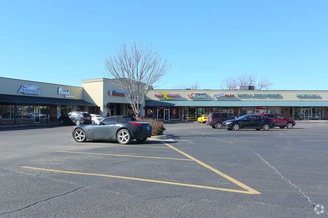
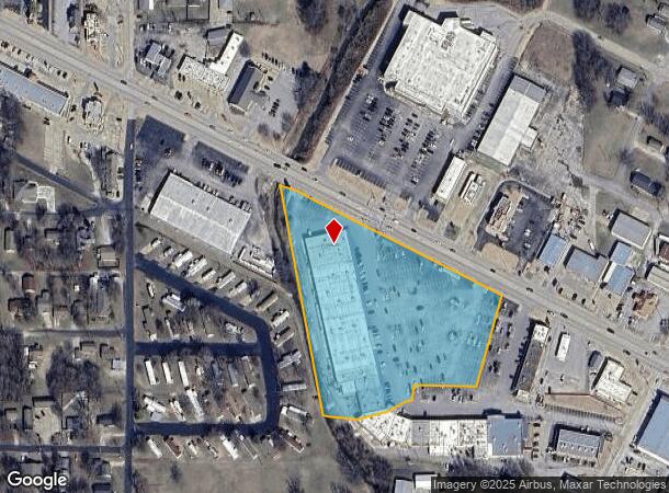
Property Record
1029 W Will Rogers Blvd, Claremore, OK 74017
NEARBY LISTINGS FOR SALE OR LEASE
Property Detail
1029 W Will Rogers Blvd
Tulsa, OK
21N-16E
660008018
TR #2, IN E2 SEC, LOT 2 OF NE- MAR CENTER BEG AT A PT ON S/L 150' W OF SE/C N2 NW SE OF SEC W ALG S/L N2 NW SE 492.5'; N 47-5
Stripcommercialcenter
Rogers
AE
Oklahoma
40131C0280H
2
2025
5.70 AC
2025
Rogers County
050104
Tulsa
106,657 SF
DEMOGRAPHICS near 1029 W Will Rogers Blvd
1 Mile
3 Mile
5 Mile
2024 Total Population
9,208
27,088
36,017
2029 Population
10,132
29,670
39,387
Pop Growth 2024-2029
+ 10.03%
+ 9.53%
+ 9.36%
Average Age
38
39
40
2024 Total Households
3,712
10,519
13,765
HH Growth 2024-2029
+ 10.21%
+ 9.68%
+ 9.49%
Median Household Inc
$48,317
$57,007
$60,504
Avg Household Size
2.30
2.40
2.50
2024 Avg HH Vehicles
2.00
2.00
2.00
Median Home Value
$136,655
$165,375
$173,713
Median Year Built
1980
1985
1987
Nearby Places
Map Layers
Map Styles
 Street
 Aerial
- Restaurants
- Banks
- Shops
- Fitness
- Groceries
PUBLIC TRANSPORTATION
AIRPORT
Tulsa International
DRIVE
WALK
Distance
Tulsa International
29 min
20.3 mi
Freight Ports
Tulsa Port Of Catoosa
DRIVE
WALK
Distance
Tulsa Port Of Catoosa
19 min
12.4 mi
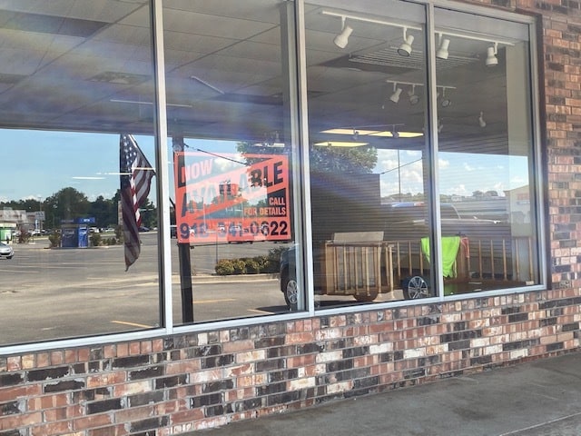
SALE & LEASE HISTORY
LISTING DATE
SALE/LEASE

Sep 25, 2016
For Lease
Oct 10, 2018
For Lease
Feb 24, 2020
For Lease
Nearby Properties
Address
Land Use
TOTAL SIZE
Lot Size
Zoning
Address
Land Use
TOTAL SIZE
Lot Size
Zoning
24,886 SF
2.05 AC
Address
Land Use
TOTAL SIZE
Lot Size
Zoning
30,872 SF
29.26 AC
Address
Land Use
TOTAL SIZE
Lot Size
Zoning
2,000 SF
13.81 AC
Address
Land Use
TOTAL SIZE
Lot Size
Zoning
35,022 SF
3.94 AC
Address
Land Use
TOTAL SIZE
Lot Size
Zoning
32,000 SF
Address
Land Use
TOTAL SIZE
Lot Size
Zoning
4,944 SF
28.82 AC
Address
Land Use
TOTAL SIZE
Lot Size
Zoning
108,802 SF
11.52 AC
Address
Land Use
TOTAL SIZE
Lot Size
Zoning
15,680 SF
10.72 AC
Address
Land Use
TOTAL SIZE
Lot Size
Zoning
5,096 SF
7.27 AC
Address
Land Use
TOTAL SIZE
Lot Size
Zoning
110,792 SF
8.46 AC
Address
Land Use
TOTAL SIZE
Lot Size
Zoning
8,632 SF
5.88 AC
Address
Land Use
TOTAL SIZE
Lot Size
Zoning
48,708 SF
1.68 AC
Address
Land Use
TOTAL SIZE
Lot Size
Zoning
1,560 SF
6.97 AC
Address
Land Use
TOTAL SIZE
Lot Size
Zoning
51,048 SF
Address
Land Use
TOTAL SIZE
Lot Size
Zoning
173,000 SF
18.49 AC
Address
Land Use
TOTAL SIZE
Lot Size
Zoning
60,037 SF
6.84 AC
Address
Land Use
TOTAL SIZE
Lot Size
Zoning
7,182 SF
1.15 AC
Address
Land Use
TOTAL SIZE
Lot Size
Zoning
14,724 SF
6 AC
Address
Land Use
TOTAL SIZE
Lot Size
Zoning
115,699 SF
5.18 AC
Address
Land Use
TOTAL SIZE
Lot Size
Zoning
42,147 SF
1.33 AC
Address
Land Use
TOTAL SIZE
Lot Size
Zoning
8,500 SF
33.42 AC
Address
Land Use
TOTAL SIZE
Lot Size
Zoning
6,400 SF
0.28 AC
Address
Land Use
TOTAL SIZE
Lot Size
Zoning
89,000 SF
Address
Land Use
TOTAL SIZE
Lot Size
Zoning
44,160 SF
4.11 AC
Address
Land Use
TOTAL SIZE
Lot Size
Zoning
450 SF
16.43 AC
Address
Land Use
TOTAL SIZE
Lot Size
Zoning
35,700 SF
Address
Land Use
TOTAL SIZE
Lot Size
Zoning
5,700 SF
1.05 AC
Address
Land Use
TOTAL SIZE
Lot Size
Zoning
418 SF
7.50 AC
Address
Land Use
TOTAL SIZE
Lot Size
Zoning
1,400 SF
0.10 AC
Address
Land Use
TOTAL SIZE
Lot Size
Zoning
75,840 SF
11.10 AC
The World's #1 Commercial Real Estate Marketplace
Connect with us
© 2026 CoStar Group
The information above has been obtained from sources believed reliable. While we do not doubt its accuracy we have not verified it and make no guarantee, warranty or representation about it. It is your responsibility to independently confirm its accuracy and completeness. Any projections, opinions, assumptions, or estimates used are for example only and do not represent the current or future performance of the property. The value of this transaction to you depends on tax and other factors which should be evaluated by your tax, financial, and legal advisors. You and your advisors should conduct a careful, independent investigation of the property to determine to your satisfaction the suitability of the property for your needs.