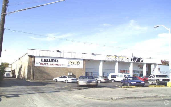
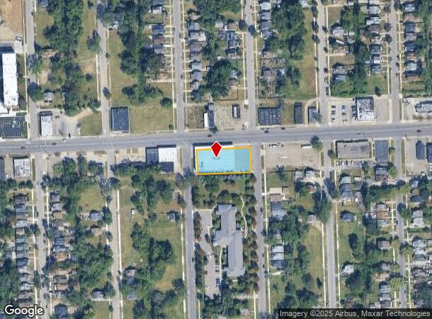
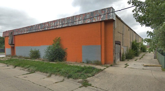
Property Record
10333 Fenkell St, Detroit, MI 48238

NEARBY LISTINGS FOR SALE OR LEASE
Property Detail
10333 Fenkell St
16-00703-545
Penn Terminal
Storebuilding
S FENKELL 145 THRU 155 PENN TERMINAL SUB L40 P68 PLATS, W C R 16/306 218 X 100
X
Wayne
26163C0100E
Michigan
2024
0.50 AC
2025
Detroit W of Woodward
536700
Detroit
16,000 SF
Detroit-Warren-Dearborn, MI
DEMOGRAPHICS near 10333 Fenkell St
1 Mile
3 Mile
5 Mile
2024 Total Population
19,044
171,252
444,328
2029 Population
18,922
170,144
442,188
Pop Growth 2024-2029
(0.64%)
(0.65%)
(0.48%)
Average Age
38
39
38
2024 Total Households
7,189
68,509
175,090
HH Growth 2024-2029
(0.64%)
(0.56%)
(0.35%)
Median Household Inc
$33,329
$36,465
$38,731
Avg Household Size
2.60
2.40
2.50
2024 Avg HH Vehicles
1.00
1.00
1.00
Median Home Value
$61,168
$83,221
$95,062
Median Year Built
1947
1948
1949
Nearby Places
Map Layers
Map Styles
 Street
 Aerial
- Restaurants
- Banks
- Shops
- Fitness
- Groceries
PUBLIC TRANSPORTATION
COMMUTER RAIL
DRIVE
WALK
Distance
11 min
6.3 mi
AIRPORT
Windsor International
DRIVE
WALK
Distance
Windsor International
37 min
18.7 mi
Detroit Metro Wayne County
DRIVE
WALK
Distance
Detroit Metro Wayne County
38 min
25.0 mi
SALE & LEASE HISTORY
LISTING DATE
SALE/LEASE

Mar 12, 2019
For Sale
Nearby Properties
Address
Land Use
TOTAL SIZE
Lot Size
Zoning
Address
Land Use
TOTAL SIZE
Lot Size
Zoning
925,367 SF
12.82 AC
R6
Address
Land Use
TOTAL SIZE
Lot Size
Zoning
783,976 SF
52.57 AC
M4
Address
Land Use
TOTAL SIZE
Lot Size
Zoning
446,500 SF
27.90 AC
Address
Land Use
TOTAL SIZE
Lot Size
Zoning
163,661 SF
8.92 AC
PD
Address
Land Use
TOTAL SIZE
Lot Size
Zoning
165,829 SF
5.56 AC
R5
Address
Land Use
TOTAL SIZE
Lot Size
Zoning
54,672 SF
1.37 AC
R6
Address
Land Use
TOTAL SIZE
Lot Size
Zoning
116,790 SF
5.86 AC
R4
Address
Land Use
TOTAL SIZE
Lot Size
Zoning
90,958 SF
11.78 AC
R5
Address
Land Use
TOTAL SIZE
Lot Size
Zoning
63,216 SF
2.87 AC
R5
Address
Land Use
TOTAL SIZE
Lot Size
Zoning
66,870 SF
2.77 AC
Address
Land Use
TOTAL SIZE
Lot Size
Zoning
100,373 SF
5.65 AC
R4
Address
Land Use
TOTAL SIZE
Lot Size
Zoning
331,590 SF
18.50 AC
M4
Address
Land Use
TOTAL SIZE
Lot Size
Zoning
315,973 SF
12.18 AC
M4
Address
Land Use
TOTAL SIZE
Lot Size
Zoning
64,566 SF
3.64 AC
PD
Address
Land Use
TOTAL SIZE
Lot Size
Zoning
7.10 AC
Address
Land Use
TOTAL SIZE
Lot Size
Zoning
Address
Land Use
TOTAL SIZE
Lot Size
Zoning
84,453 SF
4.58 AC
Address
Land Use
TOTAL SIZE
Lot Size
Zoning
68,729 SF
0.52 AC
B4
Address
Land Use
TOTAL SIZE
Lot Size
Zoning
69,712 SF
3.41 AC
PD
Address
Land Use
TOTAL SIZE
Lot Size
Zoning
46,292 SF
2.76 AC
R1
Address
Land Use
TOTAL SIZE
Lot Size
Zoning
87,232 SF
53.99 AC
R1
Address
Land Use
TOTAL SIZE
Lot Size
Zoning
122,319 SF
M4
Address
Land Use
TOTAL SIZE
Lot Size
Zoning
51,999 SF
1.14 AC
B4
Address
Land Use
TOTAL SIZE
Lot Size
Zoning
60,187 SF
3.36 AC
Address
Land Use
TOTAL SIZE
Lot Size
Zoning
57,632 SF
1.08 AC
R4
Address
Land Use
TOTAL SIZE
Lot Size
Zoning
68,071 SF
2.04 AC
PD
Address
Land Use
TOTAL SIZE
Lot Size
Zoning
46,350 SF
3.18 AC
R1
Address
Land Use
TOTAL SIZE
Lot Size
Zoning
62,874 SF
2.60 AC
R6
Address
Land Use
TOTAL SIZE
Lot Size
Zoning
54,765 SF
2.35 AC
R5
Address
Land Use
TOTAL SIZE
Lot Size
Zoning
44,415 SF
1.48 AC
The World's #1 Commercial Real Estate Marketplace
Connect with us
© 2025 CoStar Group
The information above has been obtained from sources believed reliable. While we do not doubt its accuracy we have not verified it and make no guarantee, warranty or representation about it. It is your responsibility to independently confirm its accuracy and completeness. Any projections, opinions, assumptions, or estimates used are for example only and do not represent the current or future performance of the property. The value of this transaction to you depends on tax and other factors which should be evaluated by your tax, financial, and legal advisors. You and your advisors should conduct a careful, independent investigation of the property to determine to your satisfaction the suitability of the property for your needs.