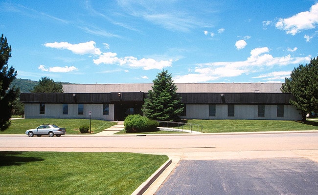
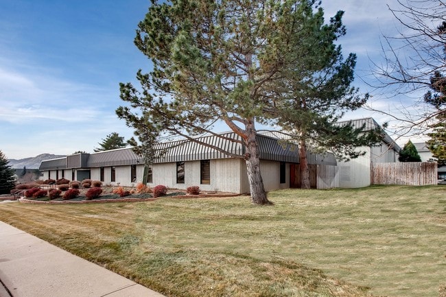
Property Record
10368 W Centennial Rd, Littleton, CO 80127

NEARBY LISTINGS FOR SALE OR LEASE
Property Detail
10368 W Centennial Rd
Denver-Aurora-Lakewood, CO
Ken Caryl Ranch Plains Ph 1-G
59-334-12-004
SECTION 33 TOWNSHIP 05 RANGE 69 QTR SE SUBDIVISIONCD 400600 SUBDIVISIONNAME KEN CARYL RANCH PLAINS PH 1-G BLOCK LOT 0001 SIZE: 174240 TRACT VALUE: 4.000
Industrialgeneral
Jefferson
X
Colorado
08059C0403F
1
2023
4 AC
2024
Southwest C-470
012024
Denver
66,230 SF
DEMOGRAPHICS near 10368 W Centennial Rd
1 Mile
3 Mile
5 Mile
2024 Total Population
10,896
61,430
128,150
2029 Population
10,752
60,301
127,477
Pop Growth 2024-2029
(1.32%)
(1.84%)
(0.53%)
Average Age
41
42
43
2024 Total Households
4,614
23,679
50,511
HH Growth 2024-2029
(1.34%)
(1.93%)
(0.42%)
Median Household Inc
$96,968
$113,250
$111,541
Avg Household Size
2.30
2.50
2.50
2024 Avg HH Vehicles
2.00
2.00
2.00
Median Home Value
$492,364
$566,137
$593,862
Median Year Built
1986
1985
1988
Nearby Places
Map Layers
Map Styles
 Street
 Aerial
- Restaurants
- Banks
- Shops
- Fitness
- Groceries
SALE & LEASE HISTORY
LISTING DATE
SALE/LEASE

Mar 30, 2017
For Sale
Jan 27, 2017
For Sale
Apr 13, 2017
For Sale
Apr 05, 2017
For Sale
Nearby Properties
Address
Land Use
TOTAL SIZE
Lot Size
Zoning
Address
Land Use
TOTAL SIZE
Lot Size
Zoning
895,137 SF
124.99 AC
PD
Address
Land Use
TOTAL SIZE
Lot Size
Zoning
272,246 SF
31.76 AC
PD
Address
Land Use
TOTAL SIZE
Lot Size
Zoning
2,884.97 AC
A1
Address
Land Use
TOTAL SIZE
Lot Size
Zoning
214,066 SF
82.60 AC
PD
Address
Land Use
TOTAL SIZE
Lot Size
Zoning
392,710 SF
21.23 AC
PD
Address
Land Use
TOTAL SIZE
Lot Size
Zoning
178,421 SF
12.31 AC
PD
Address
Land Use
TOTAL SIZE
Lot Size
Zoning
150,951 SF
17.90 AC
PD
Address
Land Use
TOTAL SIZE
Lot Size
Zoning
101,699 SF
10.34 AC
Address
Land Use
TOTAL SIZE
Lot Size
Zoning
297,003 SF
26.77 AC
PD
Address
Land Use
TOTAL SIZE
Lot Size
Zoning
119,540 SF
10.67 AC
C1
Address
Land Use
TOTAL SIZE
Lot Size
Zoning
218,391 SF
9.73 AC
PD
Address
Land Use
TOTAL SIZE
Lot Size
Zoning
120,766 SF
20.56 AC
PD
Address
Land Use
TOTAL SIZE
Lot Size
Zoning
100,550 SF
7.72 AC
PD
Address
Land Use
TOTAL SIZE
Lot Size
Zoning
107,693 SF
9.17 AC
PD
Address
Land Use
TOTAL SIZE
Lot Size
Zoning
12,367 SF
4.18 AC
Address
Land Use
TOTAL SIZE
Lot Size
Zoning
29,094 SF
11.33 AC
Address
Land Use
TOTAL SIZE
Lot Size
Zoning
59,816 SF
16.92 AC
Address
Land Use
TOTAL SIZE
Lot Size
Zoning
58,550 SF
9.67 AC
Address
Land Use
TOTAL SIZE
Lot Size
Zoning
105,392 SF
7.44 AC
Address
Land Use
TOTAL SIZE
Lot Size
Zoning
28,533 SF
11.07 AC
Address
Land Use
TOTAL SIZE
Lot Size
Zoning
71,091 SF
4.93 AC
PD
Address
Land Use
TOTAL SIZE
Lot Size
Zoning
82,765 SF
4.85 AC
PD
Address
Land Use
TOTAL SIZE
Lot Size
Zoning
137,398 SF
3.62 AC
Address
Land Use
TOTAL SIZE
Lot Size
Zoning
74,322 SF
7.87 AC
Address
Land Use
TOTAL SIZE
Lot Size
Zoning
104,984 SF
3.11 AC
Address
Land Use
TOTAL SIZE
Lot Size
Zoning
36,847 SF
3.02 AC
PD
Address
Land Use
TOTAL SIZE
Lot Size
Zoning
61,038 SF
8.19 AC
Address
Land Use
TOTAL SIZE
Lot Size
Zoning
52,803 SF
3.40 AC
PD
Address
Land Use
TOTAL SIZE
Lot Size
Zoning
40,129 SF
5.47 AC
Address
Land Use
TOTAL SIZE
Lot Size
Zoning
97,668 SF
5.90 AC
PD
The World's #1 Commercial Real Estate Marketplace
Connect with us
© 2026 CoStar Group
The information above has been obtained from sources believed reliable. While we do not doubt its accuracy we have not verified it and make no guarantee, warranty or representation about it. It is your responsibility to independently confirm its accuracy and completeness. Any projections, opinions, assumptions, or estimates used are for example only and do not represent the current or future performance of the property. The value of this transaction to you depends on tax and other factors which should be evaluated by your tax, financial, and legal advisors. You and your advisors should conduct a careful, independent investigation of the property to determine to your satisfaction the suitability of the property for your needs.