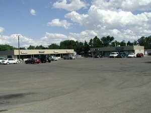
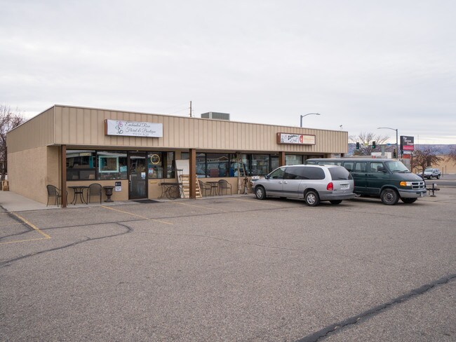
Property Record
104 Orchard Ave, Grand Junction, CO 81501

Save to a Folder
{{folder.Name}}
{{folder.ListingIds.length}} Properties
{{folder.ListingIds.length}} Property
Create a New Folder
Property Detail
104 Orchard Ave
2945-112-00-028
BEG 30FT N + 30FT E OF W4 COR SEC 11 1S 1W E 255FT N 300.8FT W 255.5FT S 300FT TO BEG EXC 5FT ON N FOR ROW AS DESC IN B-1381 P-246 & ALSO EXC ROW ON W AS DESC IN B-1844 P-975 MESA CO RECDS & ALSO EXC ROW AS DESC IN B-2339 P-535/537 MESA CO RECDS
Commercialnec
Mesa
B-1
Colorado
B and X Area of moderate flood hazard, usually the area between the limits of the 100-year and 500-year floods.
28
2023
1.72 AC
2024
Colorado Northwest Area
000400
Other Market Areas
25,965 SF
Grand Junction, CO
NEARBY LISTINGS FOR SALE OR LEASE
DEMOGRAPHICS near 104 Orchard Ave
1 mile
3 mile
5 mile
2025 Total Population
11,022
53,937
99,131
2030 Population
11,396
55,802
102,287
Pop Growth 2025-2030
+ 3.39%
+ 3.46%
+ 3.18%
Average Age
39
42
42
2025 Total Households
4,477
23,184
41,175
HH Growth 2025-2030
+ 3.86%
+ 3.69%
+ 3.41%
Median Household Inc
$49,883
$58,613
$63,779
Avg Household Size
1.90
2.10
2.30
2025 Avg HH Vehicles
1.00
2.00
2.00
Median Home Value
$338,235
$388,426
$374,817
Median Year Built
1974
1982
1986
Nearby Places
Map Layers
Map Styles
 Street
 Aerial
Layers
 Traffic
 Biking
Places
Listings with unknown addresses are not visible on the map
- Restaurants
- Banks
- Shops
- Fitness
- Groceries
PUBLIC TRANSPORTATION
COMMUTER RAIL
Grand Junction Amtrak Station (California Zephyr - Amtrak)
Drive
Walk
Distance
Grand Junction Amtrak Station (California Zephyr - Amtrak)
3 min
1.5 mi
AIRPORT
Grand Junction Regional
Drive
Walk
Distance
Grand Junction Regional
9 min
4.0 mi
Freight Ports
Port of Long Beach
Drive
Walk
Distance
Port of Long Beach
817 min
789.1 mi
SALE & LEASE HISTORY
LISTING DATE
SALE/LEASE

Mar 14, 2018
For Lease
Feb 20, 2018
For Sale
Nearby Properties
Address
Land Use
TOTAL SIZE
Lot Size
Zoning
Address
Land Use
TOTAL SIZE
Lot Size
Zoning
889,724 SF
22.01 AC
PD
Address
Land Use
TOTAL SIZE
Lot Size
Zoning
278,357 SF
29.28 AC
MU
Address
Land Use
TOTAL SIZE
Lot Size
Zoning
365,495 SF
20.90 AC
CSR
Address
Land Use
TOTAL SIZE
Lot Size
Zoning
482,392 SF
24.70 AC
CSR
Address
Land Use
TOTAL SIZE
Lot Size
Zoning
429,786 SF
16.99 AC
CSR
Address
Land Use
TOTAL SIZE
Lot Size
Zoning
440,547 SF
29.47 AC
CSR
Address
Land Use
TOTAL SIZE
Lot Size
Zoning
127,583 SF
12.35 AC
C-1
Address
Land Use
TOTAL SIZE
Lot Size
Zoning
181,976 SF
14.80 AC
CSR
Address
Land Use
TOTAL SIZE
Lot Size
Zoning
180,396 SF
17.75 AC
CSR
Address
Land Use
TOTAL SIZE
Lot Size
Zoning
90,528 SF
6.09 AC
MU
Address
Land Use
TOTAL SIZE
Lot Size
Zoning
191,078 SF
37.91 AC
Address
Land Use
TOTAL SIZE
Lot Size
Zoning
206,585 SF
18.98 AC
C-2
Address
Land Use
TOTAL SIZE
Lot Size
Zoning
70,718 SF
82.62 AC
CSR
Address
Land Use
TOTAL SIZE
Lot Size
Zoning
130,260 SF
0.20 AC
C-1
Address
Land Use
TOTAL SIZE
Lot Size
Zoning
399,553 SF
C-1
Address
Land Use
TOTAL SIZE
Lot Size
Zoning
127,269 SF
3.21 AC
B-2
Address
Land Use
TOTAL SIZE
Lot Size
Zoning
113,925 SF
0.16 AC
PD
Address
Land Use
TOTAL SIZE
Lot Size
Zoning
82,986 SF
4.20 AC
PD
Address
Land Use
TOTAL SIZE
Lot Size
Zoning
69,390 SF
0.14 AC
C-1
Address
Land Use
TOTAL SIZE
Lot Size
Zoning
94,639 SF
0.16 AC
C-1
Address
Land Use
TOTAL SIZE
Lot Size
Zoning
93,531 SF
5.19 AC
Address
Land Use
TOTAL SIZE
Lot Size
Zoning
97,602 SF
23.51 AC
RSF-4
Address
Land Use
TOTAL SIZE
Lot Size
Zoning
126,114 SF
13.75 AC
B-2
Address
Land Use
TOTAL SIZE
Lot Size
Zoning
66,178 SF
2.02 AC
PD
Address
Land Use
TOTAL SIZE
Lot Size
Zoning
86,946 SF
5.52 AC
C-1
Address
Land Use
TOTAL SIZE
Lot Size
Zoning
83,518 SF
1.45 AC
CSR
Address
Land Use
TOTAL SIZE
Lot Size
Zoning
70,394 SF
6.19 AC
PD
Address
Land Use
TOTAL SIZE
Lot Size
Zoning
215,583 SF
20.40 AC
C-1
Address
Land Use
TOTAL SIZE
Lot Size
Zoning
85,303 SF
8.45 AC
C-2
The World's #1 Commercial Real Estate Marketplace
Connect with us
© 2026 CoStar Group
The information above has been obtained from sources believed reliable. While we do not doubt its accuracy we have not verified it and make no guarantee, warranty or representation about it. It is your responsibility to independently confirm its accuracy and completeness. Any projections, opinions, assumptions, or estimates used are for example only and do not represent the current or future performance of the property. The value of this transaction to you depends on tax and other factors which should be evaluated by your tax, financial, and legal advisors. You and your advisors should conduct a careful, independent investigation of the property to determine to your satisfaction the suitability of the property for your needs.