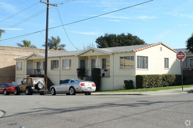
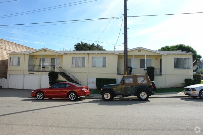
Property Record
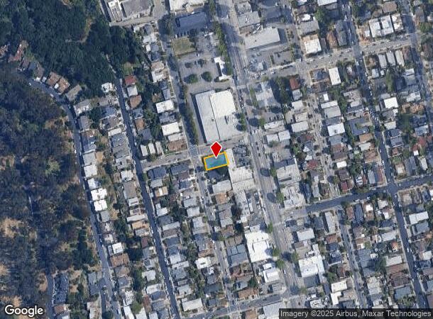
1040 Clay St, Albany, CA 94706
NEARBY LISTINGS FOR SALE OR LEASE
Property Detail
1040 Clay St
Oakland-Hayward-Berkeley, CA
Regents Park
066-2796-001-00
PRIOR REF: 2018113144 06/08/2018
Quadruplex
Alameda
X
California
06001C0018H
25&26
2024
0.12 AC
2025
Albany
420302
East Bay/Oakland
2,316 SF
DEMOGRAPHICS near 1040 Clay St
1 Mile
3 Mile
5 Mile
2024 Total Population
30,241
149,699
333,033
2029 Population
29,660
146,645
326,322
Pop Growth 2024-2029
(1.92%)
(2.04%)
(2.02%)
Average Age
40
41
39
2024 Total Households
11,646
59,715
125,879
HH Growth 2024-2029
(1.94%)
(2.14%)
(2.17%)
Median Household Inc
$109,187
$103,724
$98,449
Avg Household Size
2.50
2.30
2.40
2024 Avg HH Vehicles
2.00
1.00
2.00
Median Home Value
$1,018,990
$1,054,654
$1,000,330
Median Year Built
1952
1953
1954
Nearby Places
Map Layers
Map Styles
 Street
 Aerial
- Restaurants
- Banks
- Shops
- Fitness
- Groceries
PUBLIC TRANSPORTATION
TRANSIT/SUBWAY
El Cerrito Plaza Station (Fremont - Richmond - Bay Area Rapid Transit (BART), Richmond - Millbrae - Bay Area Rapid Transit (BART))
DRIVE
WALK
Distance
El Cerrito Plaza Station (Fremont - Richmond - Bay Area Rapid Transit (BART), Richmond - Millbrae - Bay Area Rapid Transit (BART))
2 min
12 min
0.6 mi
COMMUTER RAIL
DRIVE
WALK
Distance
7 min
2.4 mi
DRIVE
WALK
Distance
10 min
4.9 mi
AIRPORT
Metro Oakland International
DRIVE
WALK
Distance
Metro Oakland International
27 min
18.0 mi
San Francisco International
DRIVE
WALK
Distance
San Francisco International
40 min
25.6 mi
Nearby Properties
Address
Land Use
TOTAL SIZE
Lot Size
Zoning
Address
Land Use
TOTAL SIZE
Lot Size
Zoning
820,000 SF
6.36 AC
Address
Land Use
TOTAL SIZE
Lot Size
Zoning
167,071 SF
0.70 AC
Address
Land Use
TOTAL SIZE
Lot Size
Zoning
540,434 SF
14.37 AC
Address
Land Use
TOTAL SIZE
Lot Size
Zoning
395,549 SF
17.05 AC
Address
Land Use
TOTAL SIZE
Lot Size
Zoning
169,157 SF
10.20 AC
Address
Land Use
TOTAL SIZE
Lot Size
Zoning
4.77 AC
Address
Land Use
TOTAL SIZE
Lot Size
Zoning
309,451 SF
0.87 AC
Address
Land Use
TOTAL SIZE
Lot Size
Zoning
60,670 SF
1.57 AC
Address
Land Use
TOTAL SIZE
Lot Size
Zoning
123,750 SF
0.81 AC
Address
Land Use
TOTAL SIZE
Lot Size
Zoning
254,000 SF
1.71 AC
Address
Land Use
TOTAL SIZE
Lot Size
Zoning
166,731 SF
0.54 AC
Address
Land Use
TOTAL SIZE
Lot Size
Zoning
86,144 SF
0.52 AC
Address
Land Use
TOTAL SIZE
Lot Size
Zoning
159,705 SF
1.64 AC
COMM
Address
Land Use
TOTAL SIZE
Lot Size
Zoning
65,839 SF
0.62 AC
C2
Address
Land Use
TOTAL SIZE
Lot Size
Zoning
12.31 AC
Address
Land Use
TOTAL SIZE
Lot Size
Zoning
0.61 AC
Address
Land Use
TOTAL SIZE
Lot Size
Zoning
3.61 AC
Address
Land Use
TOTAL SIZE
Lot Size
Zoning
67,558 SF
0.32 AC
Address
Land Use
TOTAL SIZE
Lot Size
Zoning
136,811 SF
1.01 AC
Address
Land Use
TOTAL SIZE
Lot Size
Zoning
83,874 SF
0.60 AC
Address
Land Use
TOTAL SIZE
Lot Size
Zoning
81,410 SF
0.51 AC
Address
Land Use
TOTAL SIZE
Lot Size
Zoning
63,982 SF
0.44 AC
Address
Land Use
TOTAL SIZE
Lot Size
Zoning
75,558 SF
0.52 AC
Address
Land Use
TOTAL SIZE
Lot Size
Zoning
66,235 SF
0.46 AC
Address
Land Use
TOTAL SIZE
Lot Size
Zoning
108,048 SF
1 AC
Address
Land Use
TOTAL SIZE
Lot Size
Zoning
191,800 SF
1.09 AC
Address
Land Use
TOTAL SIZE
Lot Size
Zoning
81,149 SF
1.87 AC
Address
Land Use
TOTAL SIZE
Lot Size
Zoning
83,538 SF
0.60 AC
Address
Land Use
TOTAL SIZE
Lot Size
Zoning
139,929 SF
0.51 AC
Address
Land Use
TOTAL SIZE
Lot Size
Zoning
124,257 SF
2.72 AC
The World's #1 Commercial Real Estate Marketplace
Connect with us
© 2025 CoStar Group
The information above has been obtained from sources believed reliable. While we do not doubt its accuracy we have not verified it and make no guarantee, warranty or representation about it. It is your responsibility to independently confirm its accuracy and completeness. Any projections, opinions, assumptions, or estimates used are for example only and do not represent the current or future performance of the property. The value of this transaction to you depends on tax and other factors which should be evaluated by your tax, financial, and legal advisors. You and your advisors should conduct a careful, independent investigation of the property to determine to your satisfaction the suitability of the property for your needs.