Property Record
10400 W 44Th Ave, Wheat Ridge, CO 80033


Save to a Folder
{{folder.Name}}
{{folder.ListingIds.length}} Properties
{{folder.ListingIds.length}} Property
Create a New Folder
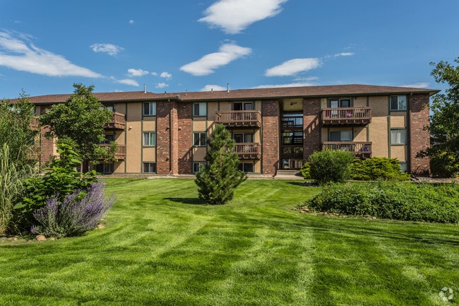
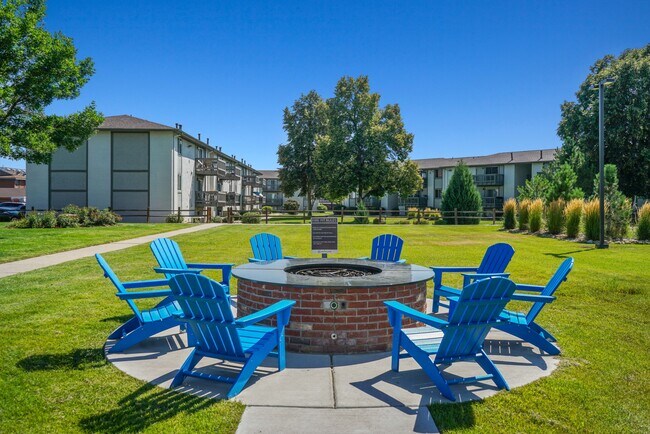
Property Detail
10400 W 44Th Ave
Denver-Aurora-Centennial, CO
SECTION 21 TOWNSHIP 03 RANGE 69 QTR NE SUBDIVISIONCD 549800 SUBDIVISIONNAME NEWGATE IN WHEAT RIDGE BLOCK LOT 0UN1 SIZE: 659498 TRACT VALUE: 15.140
39-211-11-039
Jefferson
Multifamilydwelling
Colorado
AE The base floodplain where base flood elevations are provided. AE Zones are now used on new format FIRMs instead of A1-A30 Zones.
un1
2025
15.14 AC
2025
Fruitdale
010403
Denver
152,536 SF
NEARBY LISTINGS FOR SALE OR LEASE
DEMOGRAPHICS near 10400 W 44Th Ave
1 mile
3 mile
5 mile
2025 Total Population
10,891
100,421
279,481
2030 Population
10,893
100,693
280,542
Pop Growth 2025-2030
+ 0.02%
+ 0.27%
+ 0.38%
Average Age
42
42
41
2025 Total Households
4,961
44,233
119,685
HH Growth 2025-2030
(0.16%)
+ 0.23%
+ 0.42%
Median Household Inc
$82,706
$91,627
$96,542
Avg Household Size
2.10
2.20
2.20
2025 Avg HH Vehicles
2.00
2.00
2.00
Median Home Value
$619,094
$686,465
$698,555
Median Year Built
1972
1970
1972
Nearby Places
Map Layers
Map Styles
 Street
 Aerial
Layers
 Traffic
 Biking
Places
Listings with unknown addresses are not visible on the map
- Restaurants
- Banks
- Shops
- Fitness
- Groceries
PUBLIC TRANSPORTATION
COMMUTER RAIL
Arvada Ridge Station Track 1 (Union Station to Wheat Ridge Ward Station - Regional Transportation District)
Drive
Walk
Distance
Arvada Ridge Station Track 1 (Union Station to Wheat Ridge Ward Station - Regional Transportation District)
4 min
1.9 mi
Arvada Ridge Station Track 2 (Union Station to Wheat Ridge Ward Station - Regional Transportation District)
Drive
Walk
Distance
Arvada Ridge Station Track 2 (Union Station to Wheat Ridge Ward Station - Regional Transportation District)
4 min
1.9 mi
AIRPORT
Denver International
Drive
Walk
Distance
Denver International
37 min
29.4 mi
Freight Ports
Tulsa Port Of Catoosa
Drive
Walk
Distance
Tulsa Port Of Catoosa
734 min
714.9 mi
Nearby Properties
Address
Land Use
TOTAL SIZE
Lot Size
Zoning
Address
Land Use
TOTAL SIZE
Lot Size
Zoning
830,160 SF
26.93 AC
Address
Land Use
TOTAL SIZE
Lot Size
Zoning
61,026 SF
2.81 AC
Address
Land Use
TOTAL SIZE
Lot Size
Zoning
88,507 SF
5.53 AC
Address
Land Use
TOTAL SIZE
Lot Size
Zoning
111,544 SF
2.90 AC
Address
Land Use
TOTAL SIZE
Lot Size
Zoning
80,030 SF
2.25 AC
Address
Land Use
TOTAL SIZE
Lot Size
Zoning
103,174 SF
1.23 AC
Address
Land Use
TOTAL SIZE
Lot Size
Zoning
93,699 SF
1.89 AC
Address
Land Use
TOTAL SIZE
Lot Size
Zoning
56,930 SF
7.59 AC
Address
Land Use
TOTAL SIZE
Lot Size
Zoning
97,944 SF
6.34 AC
Address
Land Use
TOTAL SIZE
Lot Size
Zoning
56,854 SF
1.83 AC
Address
Land Use
TOTAL SIZE
Lot Size
Zoning
72,252 SF
4.20 AC
Address
Land Use
TOTAL SIZE
Lot Size
Zoning
49,337 SF
4.02 AC
Address
Land Use
TOTAL SIZE
Lot Size
Zoning
51,612 SF
1.76 AC
Address
Land Use
TOTAL SIZE
Lot Size
Zoning
50,490 SF
1.58 AC
Address
Land Use
TOTAL SIZE
Lot Size
Zoning
72,630 SF
5.08 AC
Address
Land Use
TOTAL SIZE
Lot Size
Zoning
53,503 SF
2.35 AC
Address
Land Use
TOTAL SIZE
Lot Size
Zoning
111,673 SF
29.06 AC
Address
Land Use
TOTAL SIZE
Lot Size
Zoning
298,366 SF
24.21 AC
Address
Land Use
TOTAL SIZE
Lot Size
Zoning
59,824 SF
0.96 AC
Address
Land Use
TOTAL SIZE
Lot Size
Zoning
37,368 SF
0.87 AC
Address
Land Use
TOTAL SIZE
Lot Size
Zoning
42,474 SF
1.16 AC
Address
Land Use
TOTAL SIZE
Lot Size
Zoning
269,013 SF
31.89 AC
Address
Land Use
TOTAL SIZE
Lot Size
Zoning
48,252 SF
1.83 AC
Address
Land Use
TOTAL SIZE
Lot Size
Zoning
36,937 SF
0.88 AC
Address
Land Use
TOTAL SIZE
Lot Size
Zoning
125,610 SF
14.60 AC
Address
Land Use
TOTAL SIZE
Lot Size
Zoning
40,163 SF
5.46 AC
Address
Land Use
TOTAL SIZE
Lot Size
Zoning
48,225 SF
1.81 AC
Address
Land Use
TOTAL SIZE
Lot Size
Zoning
187,745 SF
16.25 AC
Address
Land Use
TOTAL SIZE
Lot Size
Zoning
187,095 SF
23.42 AC
Address
Land Use
TOTAL SIZE
Lot Size
Zoning
54,566 SF
1.39 AC
The World's #1 Commercial Real Estate Marketplace
Connect with us
© 2026 CoStar Group
The information above has been obtained from sources believed reliable. While we do not doubt its accuracy we have not verified it and make no guarantee, warranty or representation about it. It is your responsibility to independently confirm its accuracy and completeness. Any projections, opinions, assumptions, or estimates used are for example only and do not represent the current or future performance of the property. The value of this transaction to you depends on tax and other factors which should be evaluated by your tax, financial, and legal advisors. You and your advisors should conduct a careful, independent investigation of the property to determine to your satisfaction the suitability of the property for your needs.