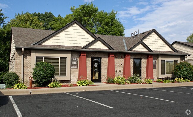
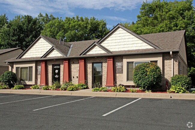
Property Record
1042 Centerville Cir, Saint Paul, MN 55127
NEARBY LISTINGS FOR SALE OR LEASE
Property Detail
1042 Centerville Cir
Minneapolis-St. Paul-Bloomington, MN-WI
Cic No 539 Hgts Plaza Townoffice Pk
21-30-22-21-0087
CIC NO 539 HGTS PLAZA TOWNOFFICE PK LOT 3 BLK 1
Officecondo
Ramsey
X
Minnesota
27003C0450E
3
2024
0.60 AC
2025
Suburban St Paul
040603
Minneapolis/St Paul
2,464 SF
DEMOGRAPHICS near 1042 Centerville Cir
1 Mile
3 Mile
5 Mile
2024 Total Population
6,809
42,901
119,666
2029 Population
6,652
41,811
117,573
Pop Growth 2024-2029
(2.31%)
(2.54%)
(1.75%)
Average Age
46
44
43
2024 Total Households
3,119
17,665
48,328
HH Growth 2024-2029
(2.56%)
(2.78%)
(2.01%)
Median Household Inc
$92,712
$91,815
$91,682
Avg Household Size
2.20
2.40
2.40
2024 Avg HH Vehicles
2.00
2.00
2.00
Median Home Value
$345,082
$331,632
$340,565
Median Year Built
1985
1981
1980
Nearby Places
Map Layers
Map Styles
 Street
 Aerial
- Restaurants
- Banks
- Shops
- Fitness
- Groceries
PUBLIC TRANSPORTATION
AIRPORT
Minneapolis-St Paul International/Wold-Chamberlain
DRIVE
WALK
Distance
Minneapolis-St Paul International/Wold-Chamberlain
30 min
20.1 mi
Freight Ports
Port Milwaukee
DRIVE
WALK
Distance
Port Milwaukee
371 min
336.5 mi
SALE & LEASE HISTORY
LISTING DATE
SALE/LEASE

Feb 22, 2019
For Lease
Nearby Properties
Address
Land Use
TOTAL SIZE
Lot Size
Zoning
Address
Land Use
TOTAL SIZE
Lot Size
Zoning
5.59 AC
Address
Land Use
TOTAL SIZE
Lot Size
Zoning
13.44 AC
Address
Land Use
TOTAL SIZE
Lot Size
Zoning
250,050 SF
2.99 AC
Address
Land Use
TOTAL SIZE
Lot Size
Zoning
106,400 SF
18.29 AC
Address
Land Use
TOTAL SIZE
Lot Size
Zoning
78,163 SF
5.62 AC
Address
Land Use
TOTAL SIZE
Lot Size
Zoning
159.37 AC
Address
Land Use
TOTAL SIZE
Lot Size
Zoning
211,420 SF
5.22 AC
Address
Land Use
TOTAL SIZE
Lot Size
Zoning
129,278 SF
4.53 AC
Address
Land Use
TOTAL SIZE
Lot Size
Zoning
126,852 SF
11.86 AC
Address
Land Use
TOTAL SIZE
Lot Size
Zoning
67,693 SF
7.30 AC
Address
Land Use
TOTAL SIZE
Lot Size
Zoning
960 SF
17.11 AC
Address
Land Use
TOTAL SIZE
Lot Size
Zoning
138,655 SF
4.70 AC
Address
Land Use
TOTAL SIZE
Lot Size
Zoning
13,358 SF
311.47 AC
W8OPSP
Address
Land Use
TOTAL SIZE
Lot Size
Zoning
3,200 SF
14.31 AC
W7PUBLC
Address
Land Use
TOTAL SIZE
Lot Size
Zoning
26,109 SF
167.19 AC
Address
Land Use
TOTAL SIZE
Lot Size
Zoning
163,709 SF
1.22 AC
Address
Land Use
TOTAL SIZE
Lot Size
Zoning
295,860 SF
11.84 AC
Address
Land Use
TOTAL SIZE
Lot Size
Zoning
147,019 SF
4.02 AC
Address
Land Use
TOTAL SIZE
Lot Size
Zoning
Address
Land Use
TOTAL SIZE
Lot Size
Zoning
204,399 SF
12.82 AC
Address
Land Use
TOTAL SIZE
Lot Size
Zoning
202,460 SF
26.72 AC
Address
Land Use
TOTAL SIZE
Lot Size
Zoning
156,090 SF
4.27 AC
Address
Land Use
TOTAL SIZE
Lot Size
Zoning
239.49 AC
Address
Land Use
TOTAL SIZE
Lot Size
Zoning
1,357 SF
8.22 AC
Address
Land Use
TOTAL SIZE
Lot Size
Zoning
88,787 SF
5.16 AC
Address
Land Use
TOTAL SIZE
Lot Size
Zoning
134,280 SF
4 AC
Address
Land Use
TOTAL SIZE
Lot Size
Zoning
234,156 SF
12.01 AC
Address
Land Use
TOTAL SIZE
Lot Size
Zoning
82,403 SF
41.35 AC
Address
Land Use
TOTAL SIZE
Lot Size
Zoning
128,462 SF
2.07 AC
Address
Land Use
TOTAL SIZE
Lot Size
Zoning
156,559 SF
18.55 AC
The World's #1 Commercial Real Estate Marketplace
Connect with us
© 2025 CoStar Group
The information above has been obtained from sources believed reliable. While we do not doubt its accuracy we have not verified it and make no guarantee, warranty or representation about it. It is your responsibility to independently confirm its accuracy and completeness. Any projections, opinions, assumptions, or estimates used are for example only and do not represent the current or future performance of the property. The value of this transaction to you depends on tax and other factors which should be evaluated by your tax, financial, and legal advisors. You and your advisors should conduct a careful, independent investigation of the property to determine to your satisfaction the suitability of the property for your needs.