Property Record
105 Maple St, Rossville, GA 30741
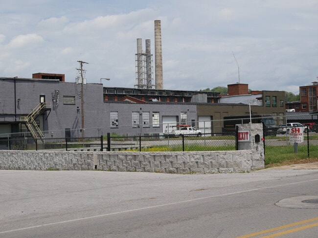

This Property Is For Sale
Current Lease Availabilities
Property Detail
105 Maple St
2007-004
PTLL 9 9/4
Industrialgeneral
Walker
I2
Georgia
AE The base floodplain where base flood elevations are provided. AE Zones are now used on new format FIRMs instead of A1-A30 Zones.
7.13 AC
2025
Walker County
2025
Chattanooga
020200
Chattanooga, TN-GA
65,000 SF
NEARBY LISTINGS FOR SALE OR LEASE
DEMOGRAPHICS near 105 Maple St
1 mile
3 mile
5 mile
2025 Total Population
6,536
50,344
124,717
2030 Population
6,718
52,252
130,039
Pop Growth 2025-2030
+ 2.78%
+ 3.79%
+ 4.27%
Average Age
38
39
39
2025 Total Households
2,521
19,601
51,245
HH Growth 2025-2030
+ 2.62%
+ 3.78%
+ 4.42%
Median Household Inc
$46,250
$50,486
$53,107
Avg Household Size
2.50
2.50
2.30
2025 Avg HH Vehicles
2.00
2.00
2.00
Median Home Value
$145,317
$190,288
$227,381
Median Year Built
1956
1961
1965
Nearby Places
Map Layers
Map Styles
 Street
 Aerial
Layers
 Traffic
 Biking
Places
Listings with unknown addresses are not visible on the map
- Restaurants
- Banks
- Shops
- Fitness
- Groceries
PUBLIC TRANSPORTATION
AIRPORT
Lovell Field
Drive
Walk
Distance
Lovell Field
20 min
10.6 mi
Nearby Properties
Address
Land Use
TOTAL SIZE
Lot Size
Zoning
Address
Land Use
TOTAL SIZE
Lot Size
Zoning
296,016 SF
13.36 AC
R3
Address
Land Use
TOTAL SIZE
Lot Size
Zoning
54,026 SF
17.89 AC
FOR R-3
Address
Land Use
TOTAL SIZE
Lot Size
Zoning
17,742 SF
8 AC
FOR PM
Address
Land Use
TOTAL SIZE
Lot Size
Zoning
19,600 SF
14.10 AC
UR
Address
Land Use
TOTAL SIZE
Lot Size
Zoning
90,565 SF
18.50 AC
FOR R-2
Address
Land Use
TOTAL SIZE
Lot Size
Zoning
1.61 AC
R2
Address
Land Use
TOTAL SIZE
Lot Size
Zoning
458,265 SF
62.80 AC
M1
Address
Land Use
TOTAL SIZE
Lot Size
Zoning
32,472 SF
17.50 AC
C1
Address
Land Use
TOTAL SIZE
Lot Size
Zoning
184,050 SF
43.42 AC
C1
Address
Land Use
TOTAL SIZE
Lot Size
Zoning
168,883 SF
14.88 AC
FOR C-2
Address
Land Use
TOTAL SIZE
Lot Size
Zoning
55,289 SF
9.33 AC
C2
Address
Land Use
TOTAL SIZE
Lot Size
Zoning
31,548 SF
7.58 AC
R3
Address
Land Use
TOTAL SIZE
Lot Size
Zoning
41,872 SF
7.09 AC
C2
Address
Land Use
TOTAL SIZE
Lot Size
Zoning
15,344 SF
13.14 AC
R3
Address
Land Use
TOTAL SIZE
Lot Size
Zoning
111,056 SF
9.89 AC
R4
Address
Land Use
TOTAL SIZE
Lot Size
Zoning
5,762 SF
3.16 AC
R3
Address
Land Use
TOTAL SIZE
Lot Size
Zoning
175,829 SF
6.36 AC
M1
Address
Land Use
TOTAL SIZE
Lot Size
Zoning
86,582 SF
10.26 AC
M1
Address
Land Use
TOTAL SIZE
Lot Size
Zoning
152,488 SF
6 AC
M1
Address
Land Use
TOTAL SIZE
Lot Size
Zoning
65,289 SF
7.05 AC
A1
Address
Land Use
TOTAL SIZE
Lot Size
Zoning
65,692 SF
5.20 AC
UR
Address
Land Use
TOTAL SIZE
Lot Size
Zoning
34,581 SF
1.98 AC
C1
Address
Land Use
TOTAL SIZE
Lot Size
Zoning
298,470 SF
15.03 AC
M1
Address
Land Use
TOTAL SIZE
Lot Size
Zoning
106,602 SF
7.35 AC
FOR C-2
Address
Land Use
TOTAL SIZE
Lot Size
Zoning
3,456 SF
2.18 AC
R3
Address
Land Use
TOTAL SIZE
Lot Size
Zoning
26,208 SF
4.71 AC
C2
Address
Land Use
TOTAL SIZE
Lot Size
Zoning
60,464 SF
4.35 AC
Address
Land Use
TOTAL SIZE
Lot Size
Zoning
296,859 SF
10.42 AC
M1
Address
Land Use
TOTAL SIZE
Lot Size
Zoning
55,382 SF
10.20 AC
FOR
Address
Land Use
TOTAL SIZE
Lot Size
Zoning
7.40 AC
R3
The World's #1 Commercial Real Estate Marketplace
Connect with us
© 2026 CoStar Group
The information above has been obtained from sources believed reliable. While we do not doubt its accuracy we have not verified it and make no guarantee, warranty or representation about it. It is your responsibility to independently confirm its accuracy and completeness. Any projections, opinions, assumptions, or estimates used are for example only and do not represent the current or future performance of the property. The value of this transaction to you depends on tax and other factors which should be evaluated by your tax, financial, and legal advisors. You and your advisors should conduct a careful, independent investigation of the property to determine to your satisfaction the suitability of the property for your needs.