Property Record
1055 N 500 W, Provo, UT 84604
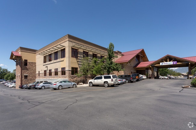

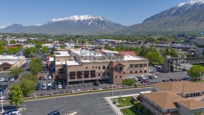
Property Detail
1055 N 500 W
Provo-Orem-Lehi, UT
LOT 1, PLAT A, CENTRAL UTAH INVESTMENT CO LLC SUBDV. AREA 10.709 AC.
36-991-0001
Utah
Commercialnec
Utah
2024
1
2025
10.71 AC
002001
Utah County
222,763 SF
Salt Lake City
NEARBY LISTINGS FOR SALE OR LEASE
DEMOGRAPHICS near 1055 N 500 W
1 mile
3 mile
5 mile
2025 Total Population
36,334
152,015
216,603
2030 Population
40,202
167,305
237,819
Pop Growth 2025-2030
+ 10.65%
+ 10.06%
+ 9.79%
Average Age
27
30
31
2025 Total Households
11,593
46,899
66,597
HH Growth 2025-2030
+ 11.81%
+ 11.20%
+ 10.83%
Median Household Inc
$51,174
$66,638
$73,177
Avg Household Size
2.80
2.90
3.00
2025 Avg HH Vehicles
2.00
2.00
2.00
Median Home Value
$465,112
$521,063
$509,204
Median Year Built
1984
1987
1988
Nearby Places
Map Layers
Map Styles
 Street
 Aerial
Layers
 Traffic
 Biking
Places
Listings with unknown addresses are not visible on the map
- Restaurants
- Banks
- Shops
- Fitness
- Groceries
PUBLIC TRANSPORTATION
COMMUTER RAIL
Provo Amtrak (California Zephyr - Amtrak)
Drive
Walk
Distance
Provo Amtrak (California Zephyr - Amtrak)
4 min
1.8 mi
Provo Central Station (FrontRunner - Utah Transit Authority (UTA))
Drive
Walk
Distance
Provo Central Station (FrontRunner - Utah Transit Authority (UTA))
4 min
2.1 mi
AIRPORT
Provo Municipal
Drive
Walk
Distance
Provo Municipal
11 min
5.2 mi
Freight Ports
Port of Stockton
Drive
Walk
Distance
Port of Stockton
757 min
738.2 mi
SALE & LEASE HISTORY
LISTING DATE
SALE/LEASE

May 29, 2025
For Lease
Nearby Properties
Address
Land Use
TOTAL SIZE
Lot Size
Zoning
Address
Land Use
TOTAL SIZE
Lot Size
Zoning
1,744,846 SF
19.25 AC
Address
Land Use
TOTAL SIZE
Lot Size
Zoning
442,598 SF
22.94 AC
Address
Land Use
TOTAL SIZE
Lot Size
Zoning
347,829 SF
5.26 AC
Address
Land Use
TOTAL SIZE
Lot Size
Zoning
1,003,185 SF
9.57 AC
Address
Land Use
TOTAL SIZE
Lot Size
Zoning
623,237 SF
14.06 AC
Address
Land Use
TOTAL SIZE
Lot Size
Zoning
530,326 SF
8.14 AC
Address
Land Use
TOTAL SIZE
Lot Size
Zoning
366,509 SF
2.83 AC
Address
Land Use
TOTAL SIZE
Lot Size
Zoning
627,022 SF
9.16 AC
Address
Land Use
TOTAL SIZE
Lot Size
Zoning
297,467 SF
16.87 AC
Address
Land Use
TOTAL SIZE
Lot Size
Zoning
310,818 SF
1.17 AC
Address
Land Use
TOTAL SIZE
Lot Size
Zoning
371,881 SF
4.91 AC
Address
Land Use
TOTAL SIZE
Lot Size
Zoning
219,346 SF
2.20 AC
Address
Land Use
TOTAL SIZE
Lot Size
Zoning
323,674 SF
13.81 AC
Address
Land Use
TOTAL SIZE
Lot Size
Zoning
245,657 SF
5.60 AC
Address
Land Use
TOTAL SIZE
Lot Size
Zoning
212,820 SF
12.90 AC
Address
Land Use
TOTAL SIZE
Lot Size
Zoning
401,381 SF
3.50 AC
Address
Land Use
TOTAL SIZE
Lot Size
Zoning
222,803 SF
18.48 AC
Address
Land Use
TOTAL SIZE
Lot Size
Zoning
268,060 SF
11.73 AC
Address
Land Use
TOTAL SIZE
Lot Size
Zoning
107,840 SF
0.98 AC
Address
Land Use
TOTAL SIZE
Lot Size
Zoning
222,848 SF
11.14 AC
Address
Land Use
TOTAL SIZE
Lot Size
Zoning
124,242 SF
9.33 AC
Address
Land Use
TOTAL SIZE
Lot Size
Zoning
266,387 SF
1.76 AC
Address
Land Use
TOTAL SIZE
Lot Size
Zoning
174,883 SF
17.42 AC
Address
Land Use
TOTAL SIZE
Lot Size
Zoning
269,652 SF
3.65 AC
Address
Land Use
TOTAL SIZE
Lot Size
Zoning
155,726 SF
13.64 AC
Address
Land Use
TOTAL SIZE
Lot Size
Zoning
300,810 SF
7.32 AC
Address
Land Use
TOTAL SIZE
Lot Size
Zoning
208,492 SF
12.49 AC
Address
Land Use
TOTAL SIZE
Lot Size
Zoning
176,127 SF
9.29 AC
Address
Land Use
TOTAL SIZE
Lot Size
Zoning
233,451 SF
1.73 AC
The World's #1 Commercial Real Estate Marketplace
Connect with us
© 2026 CoStar Group
The information above has been obtained from sources believed reliable. While we do not doubt its accuracy we have not verified it and make no guarantee, warranty or representation about it. It is your responsibility to independently confirm its accuracy and completeness. Any projections, opinions, assumptions, or estimates used are for example only and do not represent the current or future performance of the property. The value of this transaction to you depends on tax and other factors which should be evaluated by your tax, financial, and legal advisors. You and your advisors should conduct a careful, independent investigation of the property to determine to your satisfaction the suitability of the property for your needs.