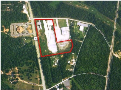
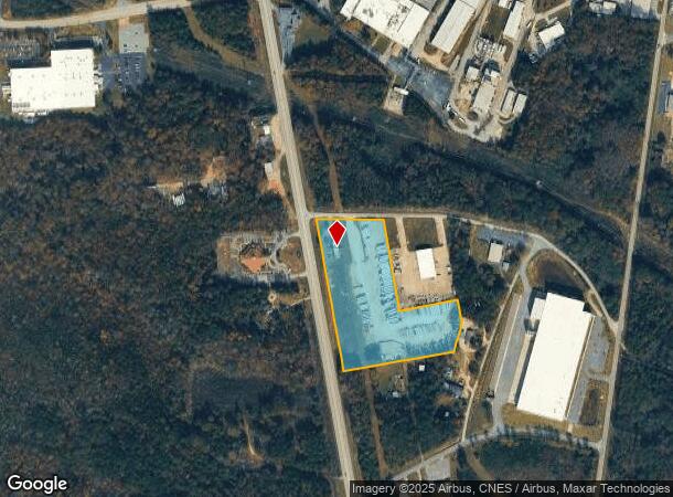
Property Record
106 Harris Ave, Greenville, SC 29611
NEARBY LISTINGS FOR SALE OR LEASE
Property Detail
106 Harris Ave
Greenville-Anderson-Greer, SC
Donaldson Heights
0593.02-01-001.00
20 THRU 36
Officebuilding
Greenville
X
South Carolina
45045C0457E
001.00
2025
9.60 AC
2024
I-85 South/Donaldson
003601
Greenville/Spartanburg
DEMOGRAPHICS near 106 Harris Ave
1 Mile
3 Mile
5 Mile
2024 Total Population
244
17,066
63,643
2029 Population
267
19,004
70,663
Pop Growth 2024-2029
+ 9.43%
+ 11.36%
+ 11.03%
Average Age
38
38
39
2024 Total Households
96
6,286
24,519
HH Growth 2024-2029
+ 9.38%
+ 11.36%
+ 11.12%
Median Household Inc
$48,749
$54,954
$58,156
Avg Household Size
2.40
2.60
2.50
2024 Avg HH Vehicles
2.00
2.00
2.00
Median Home Value
$246,296
$154,784
$183,450
Median Year Built
1992
1991
1991
Nearby Places
Map Layers
Map Styles
 Street
 Aerial
- Restaurants
- Banks
- Shops
- Fitness
- Groceries
PUBLIC TRANSPORTATION
COMMUTER RAIL
DRIVE
WALK
Distance
22 min
9.9 mi
AIRPORT
Greenville Spartanburg International
DRIVE
WALK
Distance
Greenville Spartanburg International
27 min
17.3 mi
Nearby Properties
Address
Land Use
TOTAL SIZE
Lot Size
Zoning
Address
Land Use
TOTAL SIZE
Lot Size
Zoning
78.04 AC
C2
Address
Land Use
TOTAL SIZE
Lot Size
Zoning
977.33 AC
I1
Address
Land Use
TOTAL SIZE
Lot Size
Zoning
46.07 AC
I2
Address
Land Use
TOTAL SIZE
Lot Size
Zoning
29.91 AC
Address
Land Use
TOTAL SIZE
Lot Size
Zoning
32.34 AC
Address
Land Use
TOTAL SIZE
Lot Size
Zoning
58.95 AC
Address
Land Use
TOTAL SIZE
Lot Size
Zoning
41.48 AC
I2
Address
Land Use
TOTAL SIZE
Lot Size
Zoning
12.87 AC
I2
Address
Land Use
TOTAL SIZE
Lot Size
Zoning
14.13 AC
Address
Land Use
TOTAL SIZE
Lot Size
Zoning
387.84 AC
S1
Address
Land Use
TOTAL SIZE
Lot Size
Zoning
31.52 AC
I2
Address
Land Use
TOTAL SIZE
Lot Size
Zoning
8.97 AC
Address
Land Use
TOTAL SIZE
Lot Size
Zoning
13.90 AC
I1
Address
Land Use
TOTAL SIZE
Lot Size
Zoning
33.60 AC
I1
Address
Land Use
TOTAL SIZE
Lot Size
Zoning
13.52 AC
I2
Address
Land Use
TOTAL SIZE
Lot Size
Zoning
28.29 AC
I2
Address
Land Use
TOTAL SIZE
Lot Size
Zoning
12.41 AC
RS
Address
Land Use
TOTAL SIZE
Lot Size
Zoning
385.69 AC
R10
Address
Land Use
TOTAL SIZE
Lot Size
Zoning
Address
Land Use
TOTAL SIZE
Lot Size
Zoning
13.03 AC
S1
Address
Land Use
TOTAL SIZE
Lot Size
Zoning
12.85 AC
I1
Address
Land Use
TOTAL SIZE
Lot Size
Zoning
50 AC
I2
Address
Land Use
TOTAL SIZE
Lot Size
Zoning
13.36 AC
I1
Address
Land Use
TOTAL SIZE
Lot Size
Zoning
11 AC
I1
Address
Land Use
TOTAL SIZE
Lot Size
Zoning
128.50 AC
I1
Address
Land Use
TOTAL SIZE
Lot Size
Zoning
45.10 AC
I1
Address
Land Use
TOTAL SIZE
Lot Size
Zoning
23.10 AC
S1
Address
Land Use
TOTAL SIZE
Lot Size
Zoning
12.84 AC
S1
Address
Land Use
TOTAL SIZE
Lot Size
Zoning
91.92 AC
I1
Address
Land Use
TOTAL SIZE
Lot Size
Zoning
8.14 AC
I1
The World's #1 Commercial Real Estate Marketplace
Connect with us
© 2026 CoStar Group
The information above has been obtained from sources believed reliable. While we do not doubt its accuracy we have not verified it and make no guarantee, warranty or representation about it. It is your responsibility to independently confirm its accuracy and completeness. Any projections, opinions, assumptions, or estimates used are for example only and do not represent the current or future performance of the property. The value of this transaction to you depends on tax and other factors which should be evaluated by your tax, financial, and legal advisors. You and your advisors should conduct a careful, independent investigation of the property to determine to your satisfaction the suitability of the property for your needs.