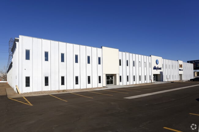
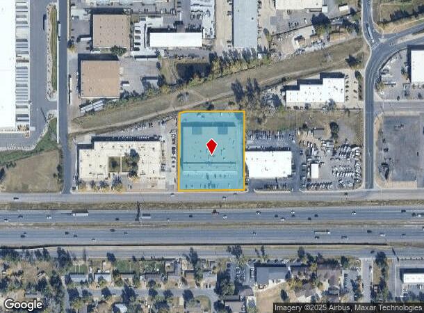
Property Record
10601 N I 70 Service Rd, Wheat Ridge, CO 80033


NEARBY LISTINGS FOR SALE OR LEASE
Property Detail
10601 N I 70 Service Rd
39-164-00-014
SECTION 16 TOWNSHIP 03 RANGE 69 QTR SE SIZE: 101320 VALUE: 2.326 KEY=042
Industrialgeneral
Jefferson
X
Colorado
08059C0211F
2.33 AC
2023
Northwest Denver
2024
Denver
010402
Denver-Aurora-Lakewood, CO
50,000 SF
DEMOGRAPHICS near 10601 N I 70 Service Rd
1 Mile
3 Mile
5 Mile
2024 Total Population
12,482
99,637
266,583
2029 Population
12,695
99,122
265,706
Pop Growth 2024-2029
+ 1.71%
(0.52%)
(0.33%)
Average Age
41
43
41
2024 Total Households
5,723
43,434
113,406
HH Growth 2024-2029
+ 1.57%
(0.59%)
(0.37%)
Median Household Inc
$77,607
$85,052
$86,812
Avg Household Size
2.10
2.20
2.30
2024 Avg HH Vehicles
2.00
2.00
2.00
Median Home Value
$466,872
$573,405
$577,777
Median Year Built
1988
1971
1973
Nearby Places
Map Layers
Map Styles
 Street
 Aerial
- Restaurants
- Banks
- Shops
- Fitness
- Groceries
PUBLIC TRANSPORTATION
AIRPORT
Denver International
DRIVE
WALK
Distance
Denver International
38 min
29.8 mi
SALE & LEASE HISTORY
LISTING DATE
SALE/LEASE

Sep 26, 2017
For Lease
Sep 25, 2016
For Lease
Nearby Properties
Address
Land Use
TOTAL SIZE
Lot Size
Zoning
Address
Land Use
TOTAL SIZE
Lot Size
Zoning
830,160 SF
26.93 AC
Address
Land Use
TOTAL SIZE
Lot Size
Zoning
269,013 SF
31.89 AC
Address
Land Use
TOTAL SIZE
Lot Size
Zoning
111,673 SF
29.06 AC
Address
Land Use
TOTAL SIZE
Lot Size
Zoning
298,150 SF
24.21 AC
Address
Land Use
TOTAL SIZE
Lot Size
Zoning
187,095 SF
23.42 AC
Address
Land Use
TOTAL SIZE
Lot Size
Zoning
187,745 SF
16.25 AC
Address
Land Use
TOTAL SIZE
Lot Size
Zoning
436,238 SF
13.94 AC
Address
Land Use
TOTAL SIZE
Lot Size
Zoning
365,230 SF
12.51 AC
Address
Land Use
TOTAL SIZE
Lot Size
Zoning
389,561 SF
10.73 AC
Address
Land Use
TOTAL SIZE
Lot Size
Zoning
131,135 SF
2.83 AC
Address
Land Use
TOTAL SIZE
Lot Size
Zoning
262,699 SF
13.10 AC
A2
Address
Land Use
TOTAL SIZE
Lot Size
Zoning
330,357 SF
15.16 AC
Address
Land Use
TOTAL SIZE
Lot Size
Zoning
241,243 SF
9.08 AC
Address
Land Use
TOTAL SIZE
Lot Size
Zoning
101,761 SF
4.34 AC
Address
Land Use
TOTAL SIZE
Lot Size
Zoning
115,719 SF
5.93 AC
Address
Land Use
TOTAL SIZE
Lot Size
Zoning
142,200 SF
9.82 AC
Address
Land Use
TOTAL SIZE
Lot Size
Zoning
520,896 SF
24.42 AC
I1
Address
Land Use
TOTAL SIZE
Lot Size
Zoning
163,361 SF
17.09 AC
Address
Land Use
TOTAL SIZE
Lot Size
Zoning
125,884 SF
8.88 AC
Address
Land Use
TOTAL SIZE
Lot Size
Zoning
91,734 SF
9.69 AC
Address
Land Use
TOTAL SIZE
Lot Size
Zoning
84,061 SF
9.08 AC
Address
Land Use
TOTAL SIZE
Lot Size
Zoning
144,325 SF
13.22 AC
Address
Land Use
TOTAL SIZE
Lot Size
Zoning
109,401 SF
12.19 AC
Address
Land Use
TOTAL SIZE
Lot Size
Zoning
114,348 SF
3 AC
Address
Land Use
TOTAL SIZE
Lot Size
Zoning
139,913 SF
2.87 AC
Address
Land Use
TOTAL SIZE
Lot Size
Zoning
121,389 SF
3.58 AC
Address
Land Use
TOTAL SIZE
Lot Size
Zoning
130,662 SF
9.67 AC
Address
Land Use
TOTAL SIZE
Lot Size
Zoning
223,338 SF
9.42 AC
I1
Address
Land Use
TOTAL SIZE
Lot Size
Zoning
86,706 SF
6.36 AC
Address
Land Use
TOTAL SIZE
Lot Size
Zoning
82,055 SF
19.39 AC
The World's #1 Commercial Real Estate Marketplace
Connect with us
© 2025 CoStar Group
The information above has been obtained from sources believed reliable. While we do not doubt its accuracy we have not verified it and make no guarantee, warranty or representation about it. It is your responsibility to independently confirm its accuracy and completeness. Any projections, opinions, assumptions, or estimates used are for example only and do not represent the current or future performance of the property. The value of this transaction to you depends on tax and other factors which should be evaluated by your tax, financial, and legal advisors. You and your advisors should conduct a careful, independent investigation of the property to determine to your satisfaction the suitability of the property for your needs.