Property Record
10650 Coit Rd, Frisco, TX 75035
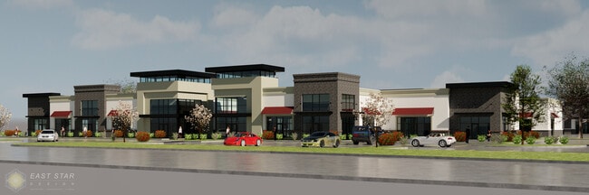


Property Detail
10650 Coit Rd
Dallas-Fort Worth-Arlington, TX
COIT HARELI ADDITION, BLK A, LOT 6
R-12508-00A-0060-1
COLLIN
Commercialnec
Texas
2025
6
2025
6.24 AC
030518
Frisco
40,146 SF
Dallas/Ft Worth
NEARBY LISTINGS FOR SALE OR LEASE
DEMOGRAPHICS near 10650 Coit Rd
1 mile
3 mile
5 mile
2024 Total Population
14,574
87,629
256,258
2029 Population
16,660
100,164
292,876
Pop Growth 2024-2029
+ 14.31%
+ 14.30%
+ 14.29%
Average Age
35
35
36
2024 Total Households
4,436
27,016
84,284
HH Growth 2024-2029
+ 14.59%
+ 14.55%
+ 14.51%
Median Household Inc
$170,143
$165,293
$158,018
Avg Household Size
3.20
3.20
3.00
2024 Avg HH Vehicles
2.00
2.00
2.00
Median Home Value
$715,193
$656,721
$676,513
Median Year Built
2010
2010
2010
Nearby Places
Map Layers
Map Styles
 Street
 Aerial
Transit
 Traffic
 Biking
Places
Listings with unknown addresses are not visible on the map
- Restaurants
- Banks
- Shops
- Fitness
- Groceries
PUBLIC TRANSPORTATION
AIRPORT
Dallas Love Field
Drive
Walk
Distance
Dallas Love Field
38 min
27.8 mi
Dallas-Fort Worth International
Drive
Walk
Distance
Dallas-Fort Worth International
35 min
28.6 mi
Freight Ports
Port of Shreveport
Drive
Walk
Distance
Port of Shreveport
241 min
221.1 mi
SALE & LEASE HISTORY
LISTING DATE
SALE/LEASE

Aug 09, 2024
For Sale
Aug 09, 2024
For Lease
Nearby Properties
Address
Land Use
TOTAL SIZE
Lot Size
Zoning
Address
Land Use
TOTAL SIZE
Lot Size
Zoning
741,280 SF
90.87 AC
Address
Land Use
TOTAL SIZE
Lot Size
Zoning
766,124 SF
62.04 AC
Address
Land Use
TOTAL SIZE
Lot Size
Zoning
494,378 SF
57.29 AC
Address
Land Use
TOTAL SIZE
Lot Size
Zoning
535,339 SF
54.76 AC
Address
Land Use
TOTAL SIZE
Lot Size
Zoning
490,246 SF
24.39 AC
MF-M
Address
Land Use
TOTAL SIZE
Lot Size
Zoning
466,467 SF
46.81 AC
Address
Land Use
TOTAL SIZE
Lot Size
Zoning
493,621 SF
17 AC
APTS
Address
Land Use
TOTAL SIZE
Lot Size
Zoning
472,446 SF
24.26 AC
MF
Address
Land Use
TOTAL SIZE
Lot Size
Zoning
505,541 SF
19.78 AC
SFR
Address
Land Use
TOTAL SIZE
Lot Size
Zoning
357,097 SF
19.68 AC
MF-M
Address
Land Use
TOTAL SIZE
Lot Size
Zoning
345,998 SF
17.81 AC
MF-M
Address
Land Use
TOTAL SIZE
Lot Size
Zoning
386,153 SF
13.83 AC
Address
Land Use
TOTAL SIZE
Lot Size
Zoning
357,411 SF
13.59 AC
MF-M
Address
Land Use
TOTAL SIZE
Lot Size
Zoning
339,685 SF
13.82 AC
MF
Address
Land Use
TOTAL SIZE
Lot Size
Zoning
352,475 SF
16.80 AC
MF-M
Address
Land Use
TOTAL SIZE
Lot Size
Zoning
300,789 SF
43.28 AC
Address
Land Use
TOTAL SIZE
Lot Size
Zoning
309,073 SF
32.96 AC
Address
Land Use
TOTAL SIZE
Lot Size
Zoning
146,061 SF
49.28 AC
NS
Address
Land Use
TOTAL SIZE
Lot Size
Zoning
173,823 SF
19.77 AC
Address
Land Use
TOTAL SIZE
Lot Size
Zoning
254,467 SF
12.74 AC
MF
Address
Land Use
TOTAL SIZE
Lot Size
Zoning
144,141 SF
17.78 AC
Address
Land Use
TOTAL SIZE
Lot Size
Zoning
168,422 SF
17.11 AC
PD
Address
Land Use
TOTAL SIZE
Lot Size
Zoning
124.08 AC
COMM
Address
Land Use
TOTAL SIZE
Lot Size
Zoning
132,636 SF
33.53 AC
Address
Land Use
TOTAL SIZE
Lot Size
Zoning
155,481 SF
20 AC
Address
Land Use
TOTAL SIZE
Lot Size
Zoning
96,173 SF
13.92 AC
Address
Land Use
TOTAL SIZE
Lot Size
Zoning
98,872 SF
10.77 AC
Address
Land Use
TOTAL SIZE
Lot Size
Zoning
91,545 SF
9.08 AC
Address
Land Use
TOTAL SIZE
Lot Size
Zoning
146,366 SF
23.38 AC
Address
Land Use
TOTAL SIZE
Lot Size
Zoning
83,993 SF
13.17 AC
The World's #1 Commercial Real Estate Marketplace
Connect with us
© 2026 CoStar Group
The information above has been obtained from sources believed reliable. While we do not doubt its accuracy we have not verified it and make no guarantee, warranty or representation about it. It is your responsibility to independently confirm its accuracy and completeness. Any projections, opinions, assumptions, or estimates used are for example only and do not represent the current or future performance of the property. The value of this transaction to you depends on tax and other factors which should be evaluated by your tax, financial, and legal advisors. You and your advisors should conduct a careful, independent investigation of the property to determine to your satisfaction the suitability of the property for your needs.