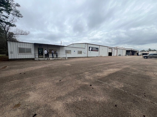
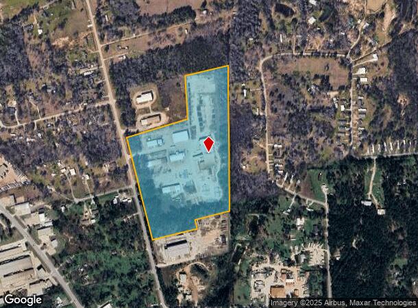
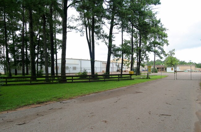
Property Record
10655 Jefferson Chemical Rd, Conroe, TX 77301
NEARBY LISTINGS FOR SALE OR LEASE
Property Detail
10655 Jefferson Chemical Rd
0272-00-00110
Howell Thos C
Industrialgeneral
A0272 - HOWELL THOS C, TRACT 1-M,1-N,1N-1,1N1-A, ACRES 25.339
X
Montgomery
48339C0395G
Texas
2024
25.34 AC
2025
The Woodlands/Conroe
693002
Houston
70,794 SF
Houston-The Woodlands-Sugar Land, TX
DEMOGRAPHICS near 10655 Jefferson Chemical Rd
1 Mile
3 Mile
5 Mile
2024 Total Population
1,306
15,616
68,634
2029 Population
1,618
19,276
84,285
Pop Growth 2024-2029
+ 23.89%
+ 23.44%
+ 22.80%
Average Age
35
35
35
2024 Total Households
385
4,915
21,644
HH Growth 2024-2029
+ 23.90%
+ 23.48%
+ 23.49%
Median Household Inc
$59,888
$67,091
$62,641
Avg Household Size
3.20
3.10
3.00
2024 Avg HH Vehicles
3.00
2.00
2.00
Median Home Value
$120,213
$205,058
$206,977
Median Year Built
2001
2002
1999
Nearby Places
Map Layers
Map Styles
 Street
 Aerial
- Restaurants
- Banks
- Shops
- Fitness
- Groceries
PUBLIC TRANSPORTATION
AIRPORT
George Bush Intcntl/Houston
DRIVE
WALK
Distance
George Bush Intcntl/Houston
45 min
35.0 mi
Freight Ports
Port of Houston
DRIVE
WALK
Distance
Port of Houston
68 min
50.8 mi
SALE & LEASE HISTORY
LISTING DATE
SALE/LEASE

Mar 27, 2024
For Lease
Nearby Properties
Address
Land Use
TOTAL SIZE
Lot Size
Zoning
Address
Land Use
TOTAL SIZE
Lot Size
Zoning
326,478 SF
20.22 AC
Address
Land Use
TOTAL SIZE
Lot Size
Zoning
242,944 SF
179.58 AC
Address
Land Use
TOTAL SIZE
Lot Size
Zoning
266,751 SF
12.95 AC
1
Address
Land Use
TOTAL SIZE
Lot Size
Zoning
186,100 SF
29.68 AC
1
Address
Land Use
TOTAL SIZE
Lot Size
Zoning
262,564 SF
51.89 AC
1
Address
Land Use
TOTAL SIZE
Lot Size
Zoning
159,185 SF
18.45 AC
1
Address
Land Use
TOTAL SIZE
Lot Size
Zoning
117,392 SF
27 AC
1
Address
Land Use
TOTAL SIZE
Lot Size
Zoning
143,641 SF
14.80 AC
1
Address
Land Use
TOTAL SIZE
Lot Size
Zoning
187,426 SF
61.77 AC
1
Address
Land Use
TOTAL SIZE
Lot Size
Zoning
140,900 SF
83.24 AC
1
Address
Land Use
TOTAL SIZE
Lot Size
Zoning
84,192 SF
23.22 AC
1
Address
Land Use
TOTAL SIZE
Lot Size
Zoning
70,912 SF
5.07 AC
1
Address
Land Use
TOTAL SIZE
Lot Size
Zoning
14,750 SF
1.66 AC
Address
Land Use
TOTAL SIZE
Lot Size
Zoning
44,182 SF
6.25 AC
1
Address
Land Use
TOTAL SIZE
Lot Size
Zoning
64,150 SF
6.41 AC
1
Address
Land Use
TOTAL SIZE
Lot Size
Zoning
60,000 SF
5.02 AC
1
Address
Land Use
TOTAL SIZE
Lot Size
Zoning
65,448 SF
10 AC
1
Address
Land Use
TOTAL SIZE
Lot Size
Zoning
Address
Land Use
TOTAL SIZE
Lot Size
Zoning
90,180 SF
3.22 AC
1
Address
Land Use
TOTAL SIZE
Lot Size
Zoning
163,880 SF
11 AC
Address
Land Use
TOTAL SIZE
Lot Size
Zoning
13,143 SF
24 AC
Address
Land Use
TOTAL SIZE
Lot Size
Zoning
31,645 SF
189.42 AC
Address
Land Use
TOTAL SIZE
Lot Size
Zoning
30,204 SF
4 AC
1
Address
Land Use
TOTAL SIZE
Lot Size
Zoning
80,948 SF
15 AC
Address
Land Use
TOTAL SIZE
Lot Size
Zoning
10,710 SF
2.54 AC
1
Address
Land Use
TOTAL SIZE
Lot Size
Zoning
19.41 AC
Address
Land Use
TOTAL SIZE
Lot Size
Zoning
23,912 SF
53.69 AC
1
Address
Land Use
TOTAL SIZE
Lot Size
Zoning
75,058 SF
12.66 AC
Address
Land Use
TOTAL SIZE
Lot Size
Zoning
9,965 SF
5.75 AC
The World's #1 Commercial Real Estate Marketplace
Connect with us
© 2026 CoStar Group
The information above has been obtained from sources believed reliable. While we do not doubt its accuracy we have not verified it and make no guarantee, warranty or representation about it. It is your responsibility to independently confirm its accuracy and completeness. Any projections, opinions, assumptions, or estimates used are for example only and do not represent the current or future performance of the property. The value of this transaction to you depends on tax and other factors which should be evaluated by your tax, financial, and legal advisors. You and your advisors should conduct a careful, independent investigation of the property to determine to your satisfaction the suitability of the property for your needs.