Property Record
1066 Killian Hill Rd Sw, Lilburn, GA 30047
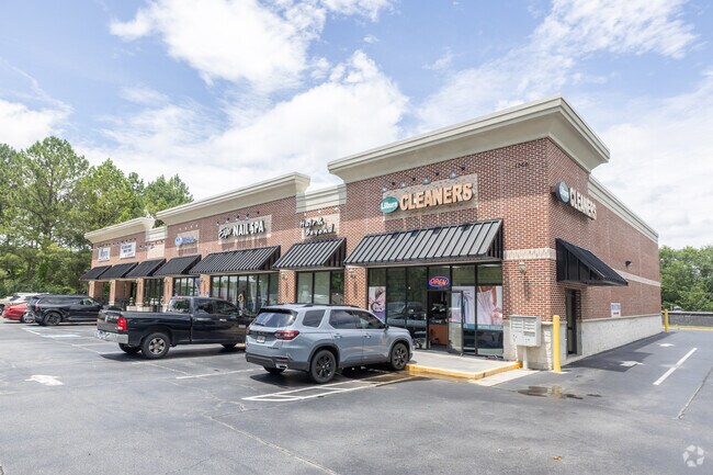


Property Detail
1066 Killian Hill Rd Sw
6-090-102
L1 BA DARLING COURT #1
Stripcommercialcenter
Gwinnett
C2
Georgia
B and X Area of moderate flood hazard, usually the area between the limits of the 100-year and 500-year floods.
1
0
0.85 AC
2025
Lilburn/Snellville
050457
Atlanta
10,650 SF
Atlanta-Sandy Springs-Roswell, GA
NEARBY LISTINGS FOR SALE OR LEASE
DEMOGRAPHICS near 1066 Killian Hill Rd Sw
1 mile
3 mile
5 mile
2025 Total Population
7,423
67,193
202,538
2030 Population
7,650
69,966
210,353
Pop Growth 2025-2030
+ 3.06%
+ 4.13%
+ 3.86%
Average Age
40
39
38
2025 Total Households
2,302
21,632
64,820
HH Growth 2025-2030
+ 3.17%
+ 4.23%
+ 3.91%
Median Household Inc
$132,354
$100,084
$85,775
Avg Household Size
3.20
3.00
3.00
2025 Avg HH Vehicles
2.00
2.00
2.00
Median Home Value
$427,477
$385,939
$370,003
Median Year Built
1984
1985
1987
Nearby Places
Map Layers
Map Styles
 Street
 Aerial
Transit
 Traffic
 Biking
Places
Listings with unknown addresses are not visible on the map
- Restaurants
- Banks
- Shops
- Fitness
- Groceries
PUBLIC TRANSPORTATION
AIRPORT
Hartsfield - Jackson Atlanta International
Drive
Walk
Distance
Hartsfield - Jackson Atlanta International
46 min
30.0 mi
SALE & LEASE HISTORY
LISTING DATE
SALE/LEASE

Sep 25, 2016
For Lease
Nearby Properties
Address
Land Use
TOTAL SIZE
Lot Size
Zoning
Address
Land Use
TOTAL SIZE
Lot Size
Zoning
301,646 SF
23.90 AC
RM13
Address
Land Use
TOTAL SIZE
Lot Size
Zoning
313,246 SF
17.15 AC
RM13
Address
Land Use
TOTAL SIZE
Lot Size
Zoning
232,617 SF
19.61 AC
RM
Address
Land Use
TOTAL SIZE
Lot Size
Zoning
287,502 SF
43.15 AC
R1
Address
Land Use
TOTAL SIZE
Lot Size
Zoning
526,306 SF
77.45 AC
R100
Address
Land Use
TOTAL SIZE
Lot Size
Zoning
278,756 SF
27.72 AC
RM
Address
Land Use
TOTAL SIZE
Lot Size
Zoning
123,713 SF
5.97 AC
C2
Address
Land Use
TOTAL SIZE
Lot Size
Zoning
53,071 SF
142.06 AC
R75
Address
Land Use
TOTAL SIZE
Lot Size
Zoning
113,100 SF
11.39 AC
C2
Address
Land Use
TOTAL SIZE
Lot Size
Zoning
38,438 SF
130.10 AC
R100
Address
Land Use
TOTAL SIZE
Lot Size
Zoning
139,448 SF
15.97 AC
RM
Address
Land Use
TOTAL SIZE
Lot Size
Zoning
99,280 SF
4.51 AC
C2
Address
Land Use
TOTAL SIZE
Lot Size
Zoning
206,183 SF
25.75 AC
C2
Address
Land Use
TOTAL SIZE
Lot Size
Zoning
106,114 SF
16.59 AC
C2
Address
Land Use
TOTAL SIZE
Lot Size
Zoning
114,672 SF
27 AC
R100
Address
Land Use
TOTAL SIZE
Lot Size
Zoning
89,686 SF
18.29 AC
C2
Address
Land Use
TOTAL SIZE
Lot Size
Zoning
106,572 SF
14.77 AC
CB
Address
Land Use
TOTAL SIZE
Lot Size
Zoning
82,087 SF
10.03 AC
C2
Address
Land Use
TOTAL SIZE
Lot Size
Zoning
48,985 SF
17.87 AC
C2
Address
Land Use
TOTAL SIZE
Lot Size
Zoning
57,322 SF
9.18 AC
C2
Address
Land Use
TOTAL SIZE
Lot Size
Zoning
77,284 SF
3.93 AC
C2
Address
Land Use
TOTAL SIZE
Lot Size
Zoning
100,000 SF
10.39 AC
C2
Address
Land Use
TOTAL SIZE
Lot Size
Zoning
230,323 SF
15 AC
R100
Address
Land Use
TOTAL SIZE
Lot Size
Zoning
99,893 SF
7.48 AC
OI
Address
Land Use
TOTAL SIZE
Lot Size
Zoning
52,262 SF
6.02 AC
C3
Address
Land Use
TOTAL SIZE
Lot Size
Zoning
83,316 SF
7 AC
R100
Address
Land Use
TOTAL SIZE
Lot Size
Zoning
103,700 SF
10.20 AC
C2
Address
Land Use
TOTAL SIZE
Lot Size
Zoning
88,110 SF
8.01 AC
C2
Address
Land Use
TOTAL SIZE
Lot Size
Zoning
120,582 SF
22.50 AC
R100
Address
Land Use
TOTAL SIZE
Lot Size
Zoning
140,226 SF
17.12 AC
C2
The World's #1 Commercial Real Estate Marketplace
Connect with us
© 2026 CoStar Group
The information above has been obtained from sources believed reliable. While we do not doubt its accuracy we have not verified it and make no guarantee, warranty or representation about it. It is your responsibility to independently confirm its accuracy and completeness. Any projections, opinions, assumptions, or estimates used are for example only and do not represent the current or future performance of the property. The value of this transaction to you depends on tax and other factors which should be evaluated by your tax, financial, and legal advisors. You and your advisors should conduct a careful, independent investigation of the property to determine to your satisfaction the suitability of the property for your needs.