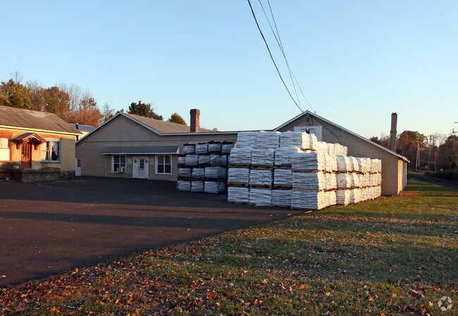
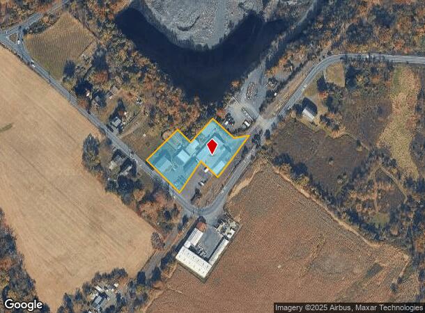
Property Record
1070 Swamp Rd, Furlong, PA 18925


NEARBY LISTINGS FOR SALE OR LEASE
Property Detail
1070 Swamp Rd
53-001-022
1.5A E S SWAMP RD 723 FT S SWAMP RD SWAMP RD
Warehouse
Bucks
X
Pennsylvania
42017C0319J
1.50 AC
2024
Bucks
2025
Philadelphia
105100
Philadelphia-Camden-Wilmington, PA-NJ-DE-MD
17,540 SF
DEMOGRAPHICS near 1070 Swamp Rd
1 Mile
3 Mile
5 Mile
2024 Total Population
421
14,093
83,089
2029 Population
412
13,895
82,435
Pop Growth 2024-2029
(2.14%)
(1.40%)
(0.79%)
Average Age
43
44
45
2024 Total Households
150
4,911
30,205
HH Growth 2024-2029
(2.67%)
(1.53%)
(0.86%)
Median Household Inc
$133,750
$136,861
$131,067
Avg Household Size
2.80
2.80
2.70
2024 Avg HH Vehicles
2.00
2.00
2.00
Median Home Value
$671,686
$598,512
$467,509
Median Year Built
1977
1986
1983
Nearby Places
Map Layers
Map Styles
 Street
 Aerial
- Restaurants
- Banks
- Shops
- Fitness
- Groceries
PUBLIC TRANSPORTATION
COMMUTER RAIL
Warminster (R2 - Southeastern Pennsylvania Transportation Authority Regional Rail (SEPTA Regional Rail))
DRIVE
WALK
Distance
Warminster (R2 - Southeastern Pennsylvania Transportation Authority Regional Rail (SEPTA Regional Rail))
16 min
7.4 mi
Doylestown (R5 - Southeastern Pennsylvania Transportation Authority Regional Rail (SEPTA Regional Rail))
DRIVE
WALK
Distance
Doylestown (R5 - Southeastern Pennsylvania Transportation Authority Regional Rail (SEPTA Regional Rail))
15 min
7.7 mi
AIRPORT
Trenton Mercer
DRIVE
WALK
Distance
Trenton Mercer
27 min
15.9 mi
Lehigh Valley International
DRIVE
WALK
Distance
Lehigh Valley International
70 min
40.0 mi
Philadelphia International
DRIVE
WALK
Distance
Philadelphia International
64 min
40.6 mi
Freight Ports
Port of Philadelphia
DRIVE
WALK
Distance
Port of Philadelphia
43 min
23.1 mi
Nearby Properties
Address
Land Use
TOTAL SIZE
Lot Size
Zoning
Address
Land Use
TOTAL SIZE
Lot Size
Zoning
89,417 SF
13.30 AC
CR
Address
Land Use
TOTAL SIZE
Lot Size
Zoning
800 SF
147.62 AC
QA
Address
Land Use
TOTAL SIZE
Lot Size
Zoning
19,410 SF
7.53 AC
IP
Address
Land Use
TOTAL SIZE
Lot Size
Zoning
70,250 SF
6.40 AC
I1
Address
Land Use
TOTAL SIZE
Lot Size
Zoning
42,588 SF
42.73 AC
AG
Address
Land Use
TOTAL SIZE
Lot Size
Zoning
78,824 SF
5.34 AC
I1
Address
Land Use
TOTAL SIZE
Lot Size
Zoning
71,654 SF
5.56 AC
I1
Address
Land Use
TOTAL SIZE
Lot Size
Zoning
83,752 SF
12 AC
LI
Address
Land Use
TOTAL SIZE
Lot Size
Zoning
1,856 SF
100 AC
RA
Address
Land Use
TOTAL SIZE
Lot Size
Zoning
22,023 SF
5.70 AC
VC2
Address
Land Use
TOTAL SIZE
Lot Size
Zoning
Address
Land Use
TOTAL SIZE
Lot Size
Zoning
18,480 SF
34.34 AC
CM
Address
Land Use
TOTAL SIZE
Lot Size
Zoning
49,680 SF
4.03 AC
I1
Address
Land Use
TOTAL SIZE
Lot Size
Zoning
23,492 SF
1.61 AC
I1
Address
Land Use
TOTAL SIZE
Lot Size
Zoning
43.44 AC
CM
Address
Land Use
TOTAL SIZE
Lot Size
Zoning
41,263 SF
4.19 AC
I-1
Address
Land Use
TOTAL SIZE
Lot Size
Zoning
4,300 SF
38.79 AC
CM
Address
Land Use
TOTAL SIZE
Lot Size
Zoning
0.33 AC
CM
Address
Land Use
TOTAL SIZE
Lot Size
Zoning
14,085 SF
2.06 AC
C2
Address
Land Use
TOTAL SIZE
Lot Size
Zoning
39,368 SF
4.84 AC
LI
Address
Land Use
TOTAL SIZE
Lot Size
Zoning
9,944 SF
2.82 AC
VC2
Address
Land Use
TOTAL SIZE
Lot Size
Zoning
39,231 SF
4.07 AC
I1
Address
Land Use
TOTAL SIZE
Lot Size
Zoning
30,040 SF
0.30 AC
I1
Address
Land Use
TOTAL SIZE
Lot Size
Zoning
1.99 AC
I1
Address
Land Use
TOTAL SIZE
Lot Size
Zoning
26,000 SF
1.82 AC
I1
Address
Land Use
TOTAL SIZE
Lot Size
Zoning
6.95 AC
CR1
Address
Land Use
TOTAL SIZE
Lot Size
Zoning
36,856 SF
2.19 AC
LI
Address
Land Use
TOTAL SIZE
Lot Size
Zoning
14,515 SF
1.12 AC
MS
Address
Land Use
TOTAL SIZE
Lot Size
Zoning
34,126 SF
47.69 AC
VR1
Address
Land Use
TOTAL SIZE
Lot Size
Zoning
29,300 SF
3.11 AC
I1
The World's #1 Commercial Real Estate Marketplace
Connect with us
© 2026 CoStar Group
The information above has been obtained from sources believed reliable. While we do not doubt its accuracy we have not verified it and make no guarantee, warranty or representation about it. It is your responsibility to independently confirm its accuracy and completeness. Any projections, opinions, assumptions, or estimates used are for example only and do not represent the current or future performance of the property. The value of this transaction to you depends on tax and other factors which should be evaluated by your tax, financial, and legal advisors. You and your advisors should conduct a careful, independent investigation of the property to determine to your satisfaction the suitability of the property for your needs.